感谢 CABLE + 梓集 予gooood分享以下内容。更多关于他们,请至:CABLE on gooood, fabersociety on gooood
Appreciation towards CABLE + fabersociety for providing the following description:
随着深圳成为2026年APEC主办城市,越来越多的人们重新思考:深圳如何在短短数十年间形成今天的城市面貌?高速发展背后,又经历了怎样的空间变迁与观念转型?
《共生之城:人与自然和谐共生的深圳实践》白皮书专题展于2026年8月11日至12月31日展出。展览以“深圳叙事”为线索,回望深圳从边陲小镇发展为国际大都市的历程,并呈现这座城市在快速城市化进程中认识、回应自然,持续探索人与自然和谐共生路径的实践。
作为总体展览中的开放实践空间,“师法自然”聚焦深圳如何从山、水等自然系统中获得启发,并将这些认识转化为生态保护、城市治理、公共空间建设与品质衡量的方法。
展厅以“问卷”与“答卷”为基础叙事结构:“问卷”回归深圳的自然底图与城市化历程,呈现高速发展带来的资源、空间与生态挑战;“答卷”则从向山学习、向水学习、融会贯通与经世致用四个层次展开,呈现深圳从划定生态边界、编织治理网络、修复河流与海岸到提出山海连城计划、深圳城市指数的持续实践。
As Shenzhen prepares to host APEC in 2026, more and more people are asking how the city took shape in just a few decades—and what spatial changes and shifts in outlook accompanied its rapid growth.
On view from August 11 to December 31, 2026, the white paper exhibition A City of Symbiosis: The Shenzhen Practice of Harmonious Coexistence between Humanity and Nature revisits the “Shenzhen Narrative”—the city’s transformation from a frontier town into an international metropolis. Set within a broader temporal and spatial context, it traces how Shenzhen has come to understand and respond to nature amid rapid urbanisation, and how it continues to explore ways for people and nature to coexist in harmony.
As an open, practice-oriented space within the larger exhibition, Learning from Nature focuses on how Shenzhen draws inspiration from natural systems such as mountains and water, and translates these insights into approaches to ecological conservation, urban governance, public-space development and quality assessment.
The exhibition is structured around Inquiry and Response. The Inquiry revisits Shenzhen’s natural foundations and urbanisation, outlining the resource, spatial and ecological challenges brought by rapid growth. The “Response” unfolds in four parts: Learning from the Mountains, Learning from the Waters, integrating these lessons, and putting them into practice. Together, they trace Shenzhen’s ongoing work—from defining ecological boundaries and building governance networks to restoring rivers and coastlines, and developing the Mountain-Sea Vistas and the Urban Index of Shenzhen (UIS).
▼展览主视觉 Exhibition key visual ©吴帆
展览叙事
Exhibition Narrative
展览强调自然并非城市发展的静态背景,而是以观往知来的谦卑态度,将自然视为深圳理解自身、逐步发展的源泉。展览叙事也来自“问与答”的核心结构:前序自深圳的山海底图与城市化历程出发,提出高速发展之后城市必须面对的资源、空间与生态问题;主体部分则从山、水、多尺度整合与方法论四个方向展开,呈现深圳如何把对自然系统的学习转化为生态保护、空间治理、公共生活和品质评价体系。
围绕每一章节的核心问题,展览提取代表性的图像、规划档案、影像、标本、模型、数据与案例文本等,共同构成层层递进的叙事线索,形成一套面向未来的“深圳答卷”。
The exhibition presents nature not as a static backdrop to urban development, but as a source from which Shenzhen can understand itself and shape its future. It approaches this relationship with humility, looking to the past to inform what lies ahead. Its narrative follows a structure of Inquiry and Response: the opening section begins with Shenzhen’s mountains, coastline and urbanisation, raising the resource, spatial and ecological challenges that accompany rapid growth. The main section then turns to mountains, water, integrated planning across scales and practical methods, showing how learning from natural systems can inform ecological conservation, spatial governance, public life and systems for assessing urban quality.
Each chapter is organised around a central inquiry. Images, planning archives, moving images, specimens, models, data and case studies come together to form a narrative that builds step by step: a “Shenzhen Response” oriented towards the future.
从自然底图提出“问卷”
From Natural Foundations to Urban Questions
展览首先追问:在成为一座超级城市之前,深圳原本是一片怎样的土地?
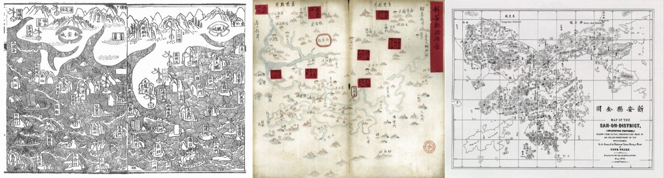
19世纪的新安县地图、地形水网资料和早期生产方式,共同呈现一副山海相拥、水脉交织的自然底图。古地图中的山脉主脊、河流入海路径、红树林、滩涂与河口湿地说明,深圳一直在复杂的地理结构与生态关系中不断生长。
The exhibition begins by asking: before it became a megacity, what kind of place was Shenzhen?
Nineteenth-century maps of Xin’an County, topographic and water-network records, and accounts of early livelihoods together reveal a natural landscape shaped by mountains, sea and interwoven waterways. Mountain ridges, river outlets, mangroves, tidal flats and estuarine wetlands on historical maps show how Shenzhen has always developed within a complex geography and ecology.
▼《新安县志·海防图》(清嘉庆《新安县志·舆地略》)、《新安县沿海图》(作者不详,大鹏半岛海洋图书馆藏)、《新安县全图》©Simeone Volonteri 绘制,1866年,澳大利亚国家图书馆藏
与这些自然底图并置的,是快速城市化带来的现实压力。城市在短时间内迅速扩张,人口、土地、资源与基础设施高度集中。2005年深圳提出的四个“难以为继”,成为展览由“问卷”进入“答卷”的关键转折。
策展在这里并非复述以速度和增长为中心的城市发展史,而是通过自然基底与城市速度的对照,解释重新认识自然的内在原因:城市的发展不只建立在对土地与资源的持续改造之上,更需要学习自然系统中的边界、循环、连通与共生。
Set alongside this natural foundation are the pressures brought by rapid urbanisation. The city expanded in a short time, concentrating population, land use, resources and infrastructure. Shenzhen’s 2005 formulation of the four unsustainable constraints marks a turning point in the exhibition, from inquiry to response.
Rather than retelling the city’s history through speed and growth alone, the exhibition places its natural foundations alongside the pace of urbanisation. This contrast explains why a renewed understanding of nature became necessary: urban development depends not only on the continued transformation of land and resources, but also on learning from the boundaries, cycles, connectivity and interdependence found in natural systems.
从山水系统寻找“答卷”
Learning from Mountains and Water
面对城市化带来的问题,深圳的“答卷”首先从如何对待山林与河海展开。
“向山学习”选择基本生态控制线作为章节起点。1986年的带状组团格局、1996年的M型生态骨架和2005年的基本生态控制线,构成一条逐渐清晰的规划线索:自然并非城市建设完成后的剩余空间,而是支撑城市结构与长期发展的基础。
In response to the challenges of urbanisation, Shenzhen’s “Response” begins with how it approaches its mountains, forests, rivers and sea.
“Learning from the Mountains” opens with the Basic Ecological Control Line. The 1986 ribbon-like cluster plan, the 1996 M-shaped ecological framework and the 2005 Basic Ecological Control Line—formalised under the Administrative Regulations of Shenzhen Municipality on the Essential Area of Protecting Ecology 2005—trace an increasingly clear planning trajectory: nature is not leftover space after urban construction, but a foundation for the city’s structure and long-term development.
▼1986年总规图、1996年总规图、深圳市基本生态控制线管理规定(2005) Master Plan of the Shenzhen Special Economic Zone (1986); Master Plan of Shenzhen City (1996); and Administrative Regulations of Shenzhen Municipality on the Essential Area of Protecting Ecology 2005 ©深圳市规划和自然资源局

在边界之外,公园分类体系、林地管理与数智护林进一步呈现,一条规划线如何通过制度、责任网络和科技平台,逐渐发展为覆盖城市、社区与山林的治理系统。自然山体所具有的结构稳定性与边界意识,由此被转化为空间规划和日常管理的方法。
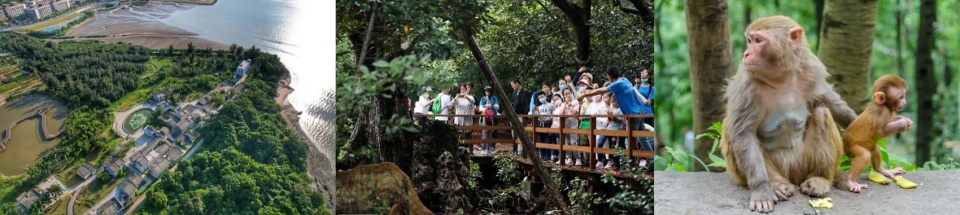
在具体而微的视角中,坝光古银叶树群、荔园外国语小学的“小森林”、塘朗山猕猴以及深圳留鸟的故事,则分别呈现古树保护、城市建设中的生境保留以及野生动物与高密度城市共处的情境:城市如何对待山林,最终体现在它是否愿意为其他生命留下位置。
Beyond the boundary, the park classification system, forestland management and digital, intelligent forest stewardship show how a planning line can develop into a governance system spanning the city, its communities and its mountain forests—through institutions, networks of responsibility and technology platforms. The stability and clear boundaries of natural mountain landscapes thus become methods for spatial planning and everyday management.
At a more intimate scale, the ancient silverback trees of Baguang, the “little forest” at Liyuan Foreign Languages Primary School, macaques on Tanglang Mountain and stories of Shenzhen’s resident birds illustrate the protection of old trees, habitat retention within urban development, and the coexistence of wildlife and a high-density city. How a city treats its forests is ultimately reflected in whether it is willing to make room for other forms of life.
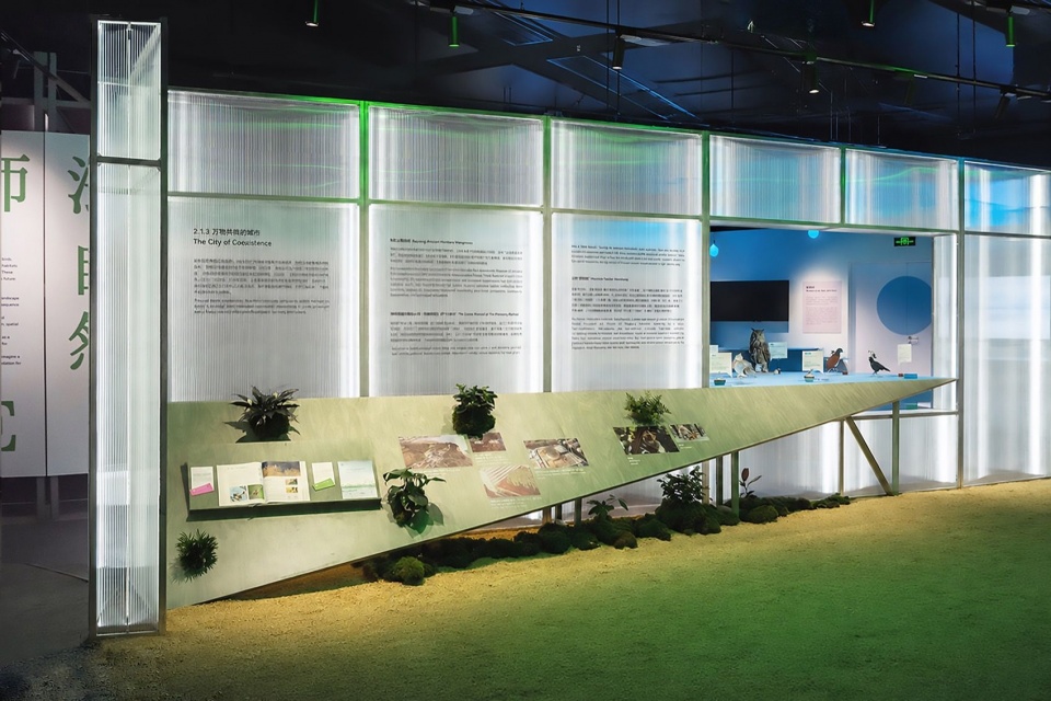
▼万物共栖的城市 A City of Coexistence ©深圳市规划和自然资源局
“向水学习”关注的则是深圳对水系认知方式的变化。水不再只是需要快速排走、截污或局部治理的对象,而被重新理解为由降雨、河流、湿地、岸线与海洋构成的连续系统。
展览以治水时间轴梳理治理逻辑的转变,并选择茅洲河、大沙河与洪湖公园三组影像作为代表性案例。影像直接呈现水质、岸线、基础设施与公共生活的变化,使观众看到深圳治水如何从末端截污和单一排洪,逐渐转向流域统筹、生态修复与滨水公共空间建设。治理不再是一次性的工程结果,而成为持续发生的城市过程。
“Learning from the Waters” follows Shenzhen’s changing understanding of its water systems. Water is no longer treated merely as something to drain quickly, intercept for pollution control or manage in isolated sections. It is understood anew as a connected system of rainfall, rivers, wetlands, shorelines and the sea.
A timeline of water management traces this shift in approach. Three groups of moving images—Maozhou River, Dasha River and Honghu Park—serve as case studies. They show changes in water quality, riverbanks, infrastructure and public life, revealing how water management in Shenzhen has moved from end-of-pipe pollution interception and flood drainage alone towards watershed-wide coordination, ecological restoration and the creation of public spaces along the water. Governance is no longer a one-off engineering outcome, but an ongoing urban process.
▼茅洲河、大沙河与洪湖公园影像,
Videos of the Maozhou River, Dasha River, and Honghu Park ©深圳市生态环境局 & 深圳市南山区 & 深圳市水务局、南沙原创建筑设计工作室

水的叙事随后沿河流抵达海岸。西部岸线以深圳湾湿地与福田红树林保护区为重点,通过湿地监控延时与护林员访谈,记录城市中心对候鸟迁徙、湿地修复与减光保护的长期守护;东部岸线则通过珊瑚保育、海洋生态修复影像和持续更新的大湾区海洋生物数字文献库,让观众得以认识通常隐藏在水面之下的海洋居民。
The story of water then follows the rivers to the coast. On the western shoreline, the focus is on the Shenzhen Bay wetlands and Futian Mangrove Nature Reserve. Time-lapse monitoring footage and interviews with forest rangers document long-term efforts in the city centre to protect migratory birds, restore wetlands and reduce light pollution. On the eastern shoreline, coral conservation, footage of marine ecological restoration and the continually updated digital catalogue of marine life in the Greater Bay Area introduce visitors to marine species usually hidden beneath the surface.
▼红树林监控影像、红树林护林员访谈与海洋生物数字文献库
Mangrove monitoring footage, an interview with a mangrove ranger, and the Marine Biodiversity Digital Library ©深圳市规划和自然资源局 & 晶报 & 大鹏半岛海洋图书馆

这些展项使长期、难以被持续观察的生态变化进入展览,也共同说明深圳对河海的态度如何从控制和利用,逐渐转向理解、修复与共生。
Together, these exhibits bring long-term ecological changes—often difficult to observe continuously—into view. They also show how Shenzhen’ s relationship with its rivers and sea has gradually shifted from control and use towards understanding, restoration and coexistence.
从实践形成方法
From Practice to Method
“融会贯通”不是将山林与河海案例简单相加,而是进一步追问:深圳如何将分散的山体、海湾、河流、公园、绿道与城市公共空间重新组织为一个整体?
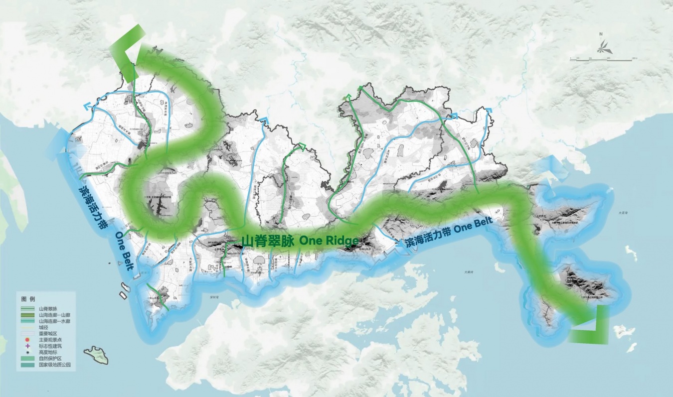
展览通过区域绿道研究、生态安全体系规划、“一脊一带二十廊”与相关设计导则,呈现“山海连城”从前期研究、空间构想到建设行动的形成过程。它并非突然出现的项目口号,而是在长期规划与实践中逐步生成的城市系统。
“Integration” goes beyond bringing together examples from the mountains, forests, rivers and sea. It asks how Shenzhen can connect its mountains, bays, rivers, parks, greenways and public spaces as part of a larger whole.
Through studies of regional greenways, ecological security planning, the “One Ridge, One Belt, Twenty Corridors” framework and related design guidelines, the exhibition traces how the Mountain-Sea Vistas developed from early research and spatial concepts into action. It is an urban system shaped through long-term planning and practice.
▼山海连城“一脊一带二十廊” Mountain-Sea Vistas: “One Ridge, One Belt, Twenty Corridors ©CABLE
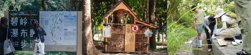
鲲鹏径被选择为这一章节的核心案例,因为它将宏观的山海结构转化为公众能够亲身进入的城市体验。前期踏勘、低干预步道、自然教育和万桥计划,则进一步将“连接”落实到不同尺度:既包括横贯城市的山海徒步网络,也包括为小型动物打通最后一米生态断点的微型设施。人与自然的关系由此不再只存在于规划图中,而是在一次行走、一处生境修复和一座跨越道路的生态桥中被具体建立。
The Kunpeng Trail is the chapter’s central case study, translating the city’s mountain-and-sea structure into an experience people can explore. Surveys, low-impact trails, nature education and the Linking Plan put “connection” into practice at different scales: from a city-spanning hiking network to small structures bridging ecological gaps for small animals. The relationship between people and nature takes shape in a walk, a restored habitat and an ecological bridge over a road.
▼低干预步道与万桥计划 Low-impact trails on the Kunpeng Trail and the Linking Plan ©方向生态
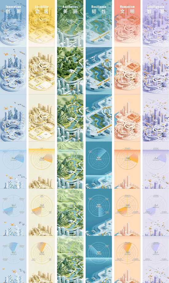
从山林到流域,从公共空间到城市韧性,展览一路走来,铺陈的是深圳与自然共生的实践答卷。收尾之处,我们以深圳城市指数(UIS)收束这份“答卷”——它承载着深圳经济特区建立以来的实践经验与系统性总结,为全球城市、尤其是面临快速发展挑战的城市提供的可操作、可借鉴、可复制的“中国方案”,构建起“创新、宜居、美丽、韧性、文明、智慧”六大维度综合评价体系。
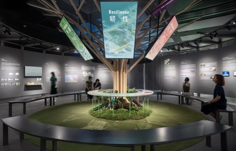
如何让观众在有限的参观时间中理解六个彼此关联的城市评价维度,是这一章节的核心策展核心。为此,六块屏幕悬于枝头,城市空间、基础设施、生活现场、动态图表与数据流在此交汇,构成一座多屏环绕的影像矩阵,让观众在流动的视听节奏中,读懂一座城市如何被UIS六大核心维度系统性“解码”。
From forests and watersheds to public space and urban resilience, the exhibition traces Shenzhen’s ongoing response to how a city can live in balance with nature. It concludes with the Urban Index of Shenzhen (UIS), which synthesises experience gained since the establishment of the Shenzhen Special Economic Zone. As an actionable and adaptable “China solution” for cities worldwide, especially those facing rapid growth, the UIS offers an integrated evaluation framework across six dimensions: Innovation, Liveability, Beauty, Resilience, Civilisation and Intelligence.
The curatorial challenge is to help visitors grasp six interconnected dimensions of urban evaluation within a limited visit. Six screens hang from the installation’s branches, bringing together urban spaces, infrastructure, scenes of everyday life, animated charts and data streams. This immersive image matrix invites visitors to see how the UIS “decodes” a city through its six core dimensions.
▼ UIS六维主题影片, Six-dimensional theme video ©CABLE
从自然底图提出问题,从山水实践寻找回应,再以山海连城与UIS形成城市方法,“问卷—答卷”并不是一份完成式的成果汇编,而是一条深圳持续认识、学习自然并修正自身的发展路径。
Beginning with the Inquiry drawn from Shenzhen’s natural foundations, the exhibition looks to practices shaped by mountains and water for responses, then brings these insights together through the Mountain-Sea Vistas and the UIS. The “Inquiry–Response” narrative is not a catalogue of finished achievements, but an ongoing path through which Shenzhen learns from and adapts to nature.
展陈设计
Exhibition Design
展陈设计从圆的原型开始。圆意味着人们可在环绕、停留与回望中观看内容,也可以在其中相遇和交流。这种开放而向心的空间关系,与“师法自然”所强调的学习、汇聚、相遇和传播相呼应:展览不仅呈现深圳向自然学习的造城实践,也希望为不同知识、经验与人群之间的交流提供场所。
圆并不是在空间划分完成后附加的几何造型,而是整个展陈设计的生成起点。设计首先在既有建筑中确立这一公共核心,再依据圆的边界、切线及其与建筑外围之间的关系,形成不同的展示区域。外围空间承担相对连续的阅读界面,观众沿展柜、展桌与展墙依次进入自然底图、发展挑战和城市实践;中央圆厅则允许停留、回望与交谈,将前述分散展开的山、水、海与城市方法重新汇聚。二者共同形成“阅读—汇聚”的参观节奏。
The exhibition design begins with the circle. Visitors can view the content as they move around it, pause and look back, while also meeting and talking within it. This open, inward-facing spatial arrangement echoes the exhibition’s themes of learning, gathering, encounter and exchange. The exhibition presents Shenzhen’s practice of learning from nature in shaping the city and creates room for different forms of knowledge, experience and community to meet.
The circle is not a geometric form added after the space has been divided; it is the generative starting point of the design. Set within the existing building, this public core uses its perimeter, tangents and relationship to the surrounding architecture to define exhibition areas. The outer space creates a continuous reading route through Shenzhen’s natural foundations, development challenges and urban practices. The central rotunda invites visitors to pause, look back and talk, bringing together the themes of mountains, water, sea and urban methods. Together, the two areas create a rhythm of reading and gathering.
▼ 展厅轴测图 Axonometric view of the exhibition space ©CABLE
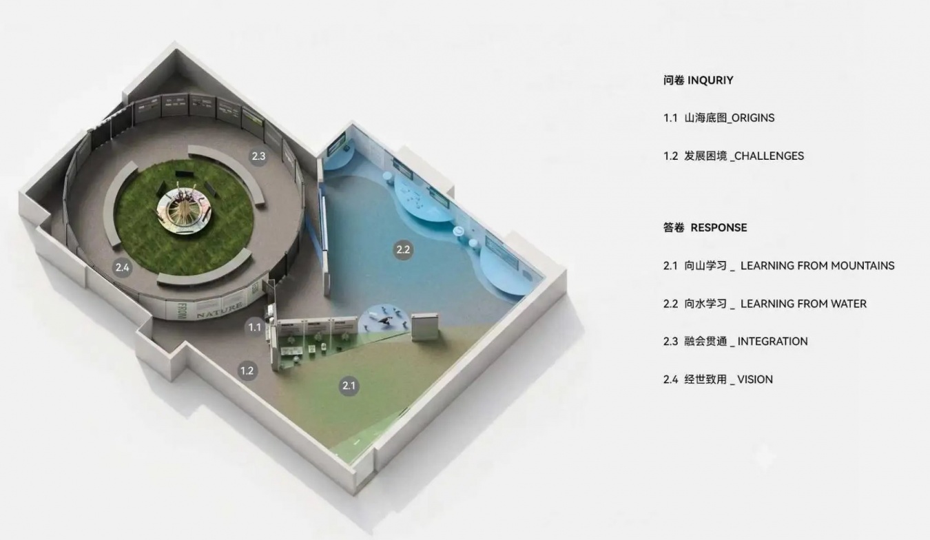
圆形内核的选择,也来自对展览生命周期的考量。作为临展,“师法自然”的作品、装置需考虑可迭代、可替换;而作为空间骨架的圆形结构则可独立存续,在展览主体拆除后依旧可用于讲座、现场导览、学术讨论、小型文化沙龙等活动,持续作为公众交流对话的场地。
The circular core also responds to the exhibition’s lifecycle. As a temporary exhibition, Learning from Nature requires works and installations that can be updated or replaced. The circular structure can remain after the exhibition is dismantled, continuing to host talks, guided tours, academic discussions and small cultural gatherings as a place for public exchange.
汇聚交流
Gathering Space
圆厅由24块模块化碳晶板围合而成。连续的深灰色板面形成完整而克制的圆形边界,同时保留标准化构件的拼接节奏。圆周既是图文内容的展示界面,也从外围参观路径中划分出一处能够停留、交流与整体观看的公共空间。
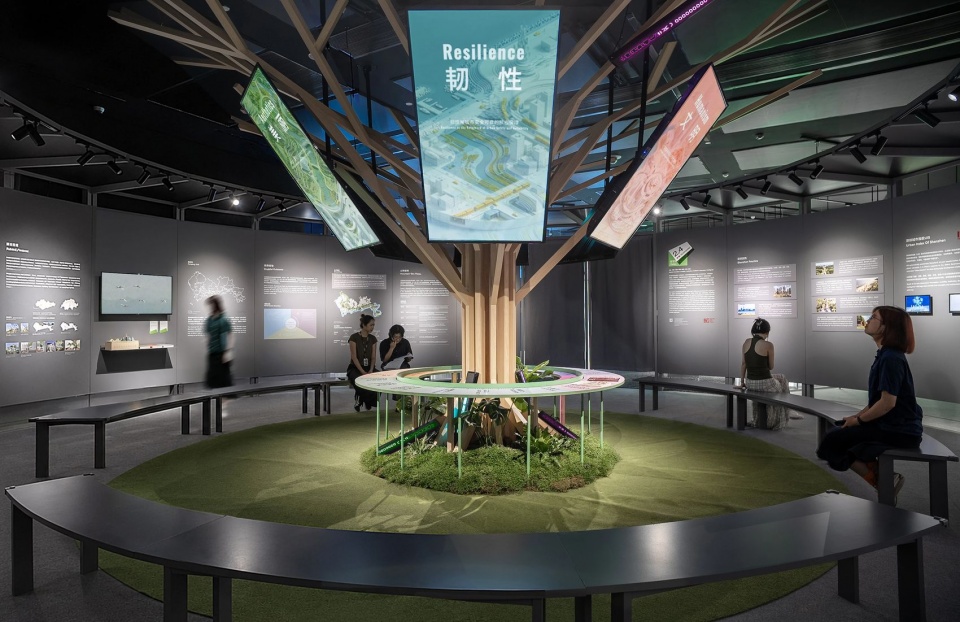
圆厅中央设置树状装置。木质杆件从中心向上生长并逐渐分叉,六台大屏幕朝向不同方向悬挂,同步播放着一组多通道影像作品。装置不设唯一观看面,观众需要在移动中逐步理解不同维度之间既各自展开又相互支撑的关系。抽象的城市指数由此被转化为一棵可被环绕观看的“城市之树”。
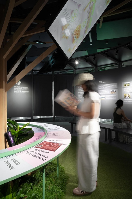
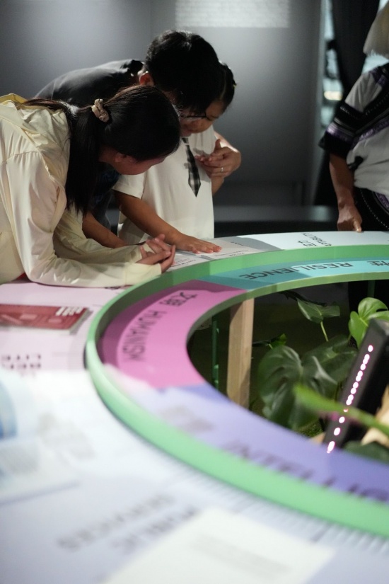
树状装置下方设置环形展桌,外围座椅顺应圆周展开,共同形成由中心装置、信息阅读到休息交流的空间层次。观众可以面向影片和展墙,也可以彼此交谈。圆厅因而不仅是参观动线的汇合点,也是一处容纳导览、讨论与小型公共活动的交流场所。
The rotunda is enclosed by 24 modular carbon-crystal panels. Their continuous dark-grey surfaces form a restrained circular boundary while retaining the rhythm of standardised components. The circumference serves as a display surface and defines a public space for pausing, conversation and viewing the exhibition as a whole.
A tree-like installation stands at the centre of the rotunda. Wooden members rise and branch out, supporting six large screens that face different directions and play a multichannel film. There is no single viewing position; visitors move around the installation to see how the dimensions unfold individually while supporting one another. The abstract urban index becomes a “city tree” viewed from all sides.
A circular display table sits beneath the tree-like installation, with seating arranged along the perimeter. Together, they create spaces for viewing, reading, resting and talking. Visitors can face the film and exhibition walls or turn to one another. The rotunda is both a meeting point along the visitor route and a place for tours, discussions and small public programmes.
▼ 树状六屏装置与环形家具 Six-screen tree installation and furniture ©CABLE
▼ 树下环形展桌 Circular display table beneath the installation ©CABLE
蓝绿流动
Layered Blue-Green
圆形与建筑边界之间的分割的外围空间,被组织为渐进叠加的蓝绿场域。设计没有将“向山学习”与“向水学习”处理为彼此封闭的主题布景,而是以相近的轻质结构、颗粒铺地、半透明材料和环境照明建立连续性,再通过色彩、家具形态与展示介质形成差异。
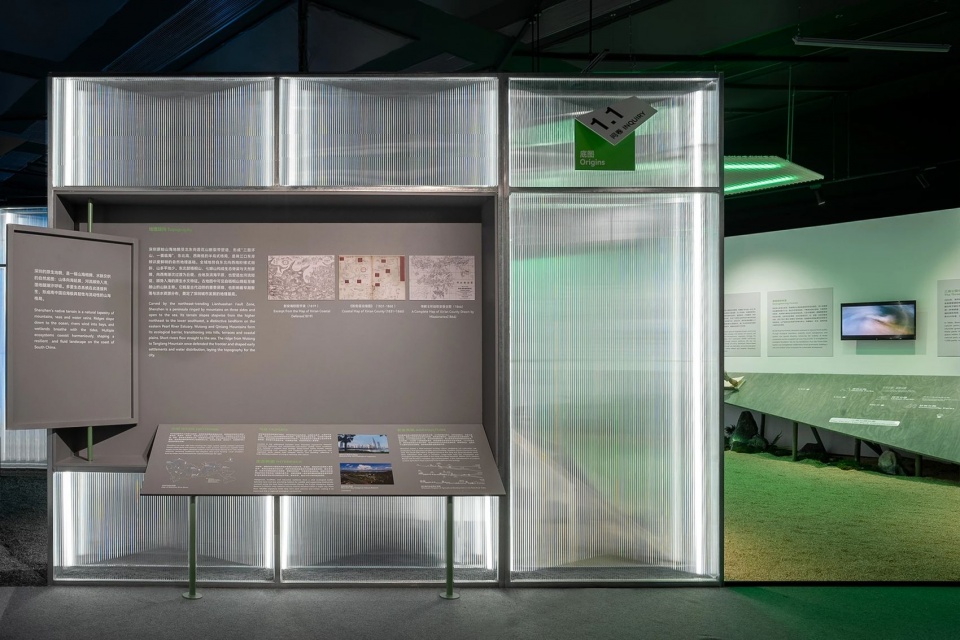
“问卷”部分采用铝型材与阳光板构成复合展陈单元。历史地图被置于垂直展面,规划档案和发展材料则进入较低的倾斜阅读台,使远距离观看与近距离阅读在同一构件中完成。半透明界面过滤后方蓝绿空间的光线,观众在阅读城市问题时,已经能够隐约感知“答卷”的存在。
The space between the circle and the building perimeter is organised as a gradually layered blue-green setting. Rather than treating “Learning from the Mountains” and “Learning from the Waters” as separate themed sets, the design connects them through lightweight structures, granular flooring, translucent materials and ambient lighting, while using colour, furniture and display media to distinguish each area.
The “Inquiry” area uses display units made of aluminium profiles and polycarbonate panels. Historical maps occupy vertical surfaces, while planning archives and development materials sit on lower, angled reading tables, allowing visitors to view and read within the same structure. The translucent panels filter light from the blue-green areas beyond, hinting at the “Responses” as visitors consider the city’s challenges.
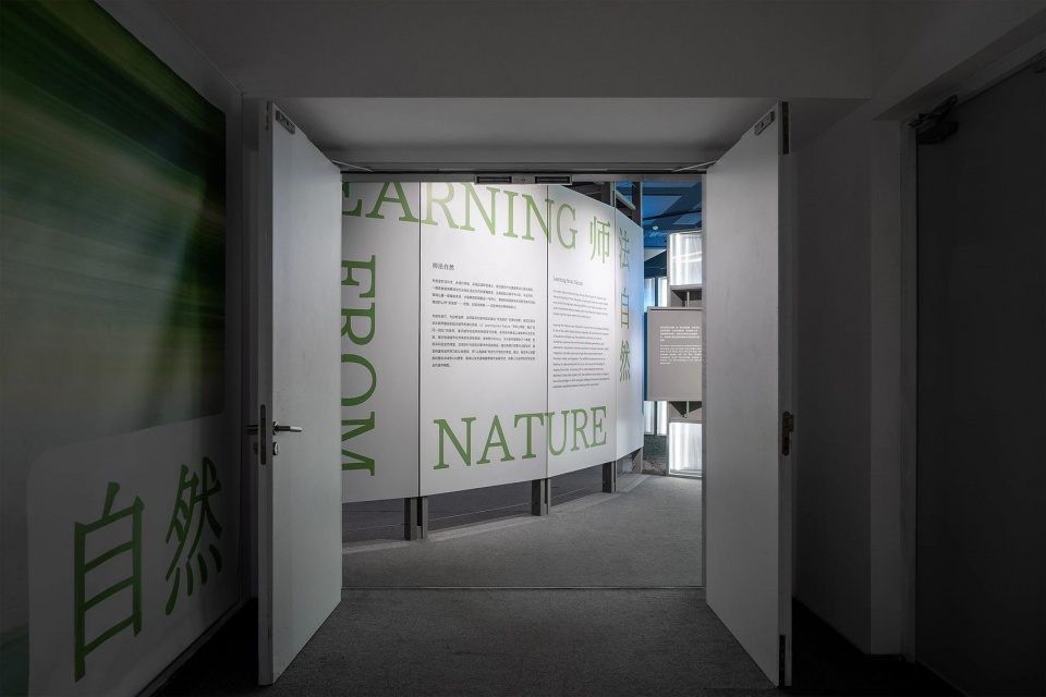
▼ 展厅入口前言 The exhibition entrance ©CABLE
▼ 问卷部分的展陈单元 Display units in the “Inquiry” section ©CABLE
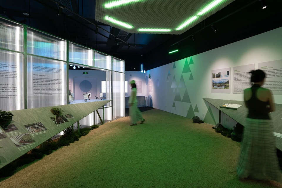
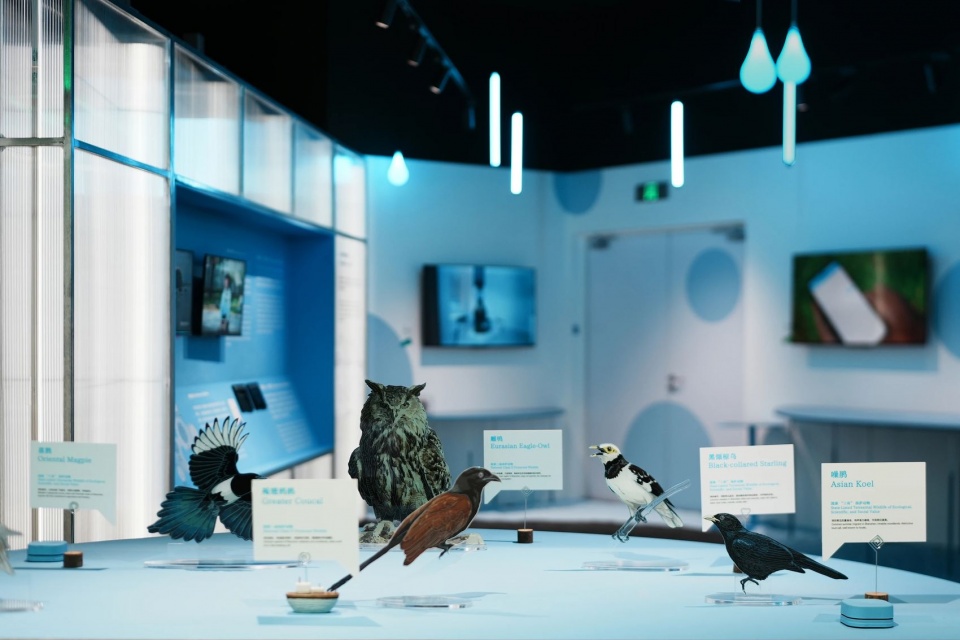
绿色空间以两侧连续的三角形斜面展桌组织观看。桌体的起伏回应山体形态,并使地图、图书、植物与生物共栖案例在不同高度上展开。浅色碎石、山石与低矮植物形成连续的地面基底,线性灯具则建立柔和的绿色环境光。阳光板上的开口既用于陈列鸟类标本,也将视线引向相邻的蓝色空间,使山林与水岸在游走中相连。
In the green area, continuous triangular sloping tables guide the visitor’s view. Their undulating forms echo mountain terrain, presenting maps, books, plants and examples of human-wildlife coexistence at different heights. Pale gravel, rocks and low plants form a continuous ground layer, while linear lights cast a soft green glow. Openings in the polycarbonate panels display bird specimens and draw the eye towards the adjacent blue area, linking forest and waterfront along the route.
▼ 绿色三角展桌与植物地景 Triangular green display tables and planted landscape ©CABLE
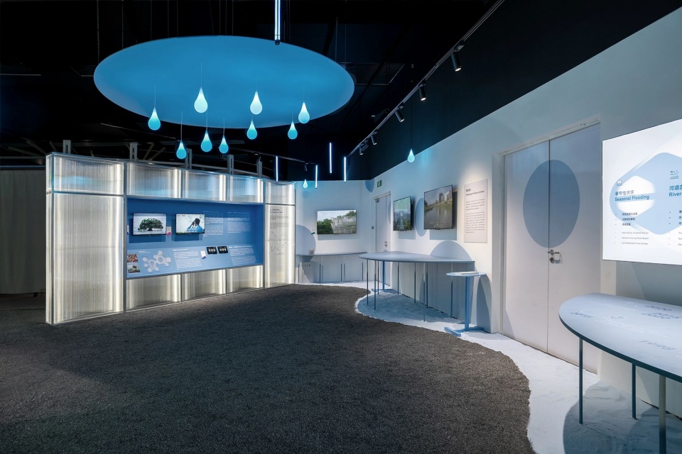
蓝色空间延续颗粒铺地和轻质展具的设计语言,以黑色石子与蓝色细沙形成近似水体、浅滩和岸线的地面边界。半圆展桌承担连续的时间线与案例叙事,小型展桌则作为分散的信息节点;顶部水滴灯具、灯箱与少量动态影像,共同回应水的汇聚、流动和渗透。
The blue area continues the use of granular flooring and lightweight display furniture. Black pebbles and blue sand define ground patterns suggestive of water, shallows and shorelines. Semicircular tables carry the timeline and case studies, while smaller tables act as information points. Drop-shaped lights, lightboxes and selected moving images evoke water gathering, flowing and seeping through the landscape.
▼黑色石子、蓝色细沙与半圆展桌 Black pebbles, blue sand and semicircular display tables ©CABLE
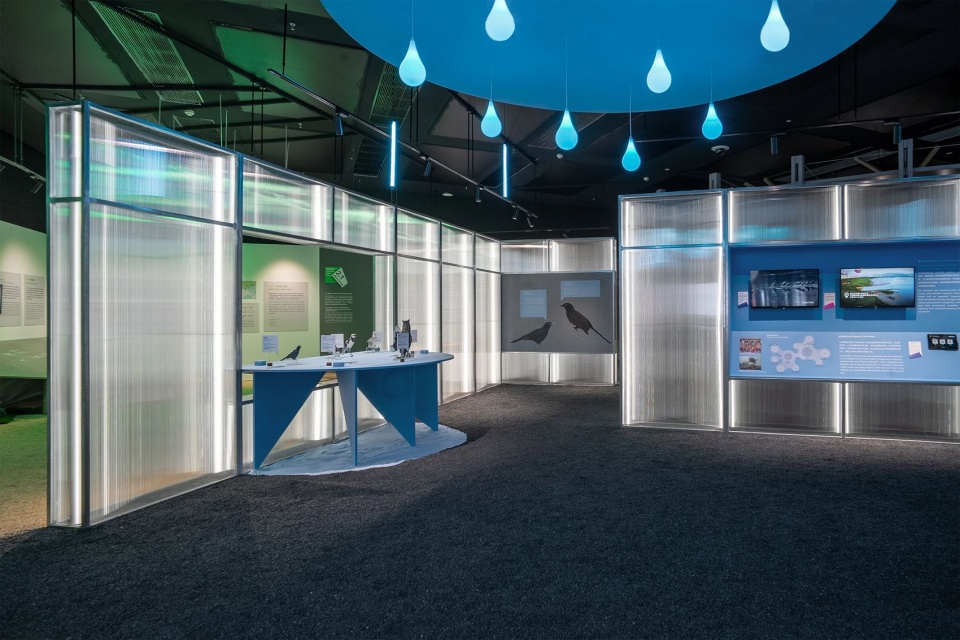
▼鸟类装置 Bird installation ©CABLE
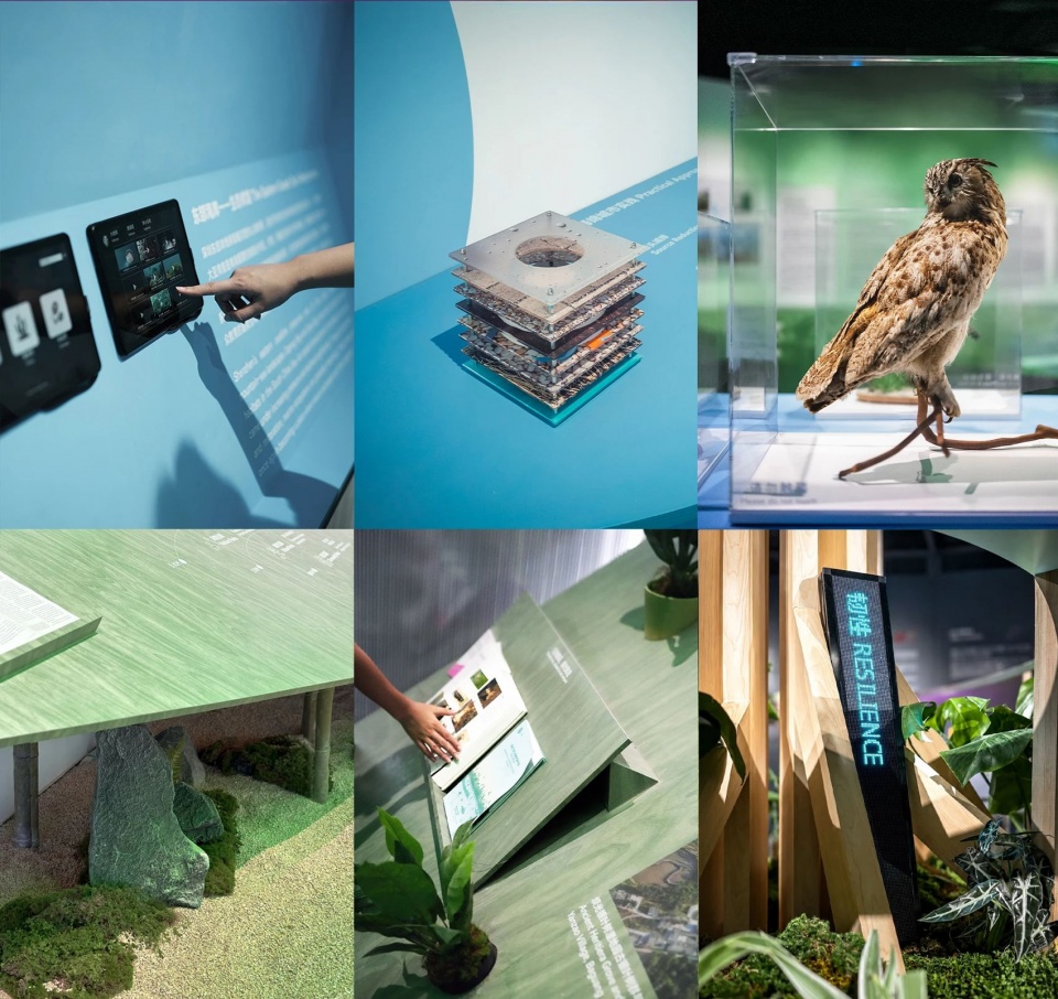
▼展览细节 Exhibition detail ©CABLE
项目名称:师法自然 Learning from Nature
指导单位:深圳市规划和自然资源局(市林业局)、深圳市海洋发展局、国际红树林中心秘书处
主办单位:深圳市当代艺术与城市规划馆
项目面积:246㎡
设计时间:2026年
建成时间:2026年
展览策划:CABLE
策划团队:何柳、熊致睿、陈沛、卢雪婷
展陈设计:梓集fabersociety
设计团队:左龙、程梅、胡悦、赵启帆、王一凡、邱翔、葛乐鹏、单逸聪
视觉设计:吴帆
施工团队:乐造展务
总展览名称:深圳叙事:人与自然和谐共生的城市实践
开放时间:2026年8月11日至2026年12月31日
公司网站:
www.citycable.cn
www.fabersociety.cn
项目地址:中国广东省深圳市福田区福中路当代艺术与城市规划馆五层西厅
Project: Learning from Nature
Category: Museums & Exhibit/Installation
Guidance: Urban Planning and Natural Resources Bureau of Shenzhen Municipality (Municipal Forestry Administration), Ocean Development Bureau of Shenzhen Municipality, and Secretariat of the International Mangrove Center
Presented by: Shenzhen Museum of Contemporary Art and Urban Planning (MOCAUP)
Area: 246 sq m
Design: 2026
Completed: 2026
Exhibition curation: CABLE
Curatorial team: He Liu, Xiong Zhirui, Chen Pei and Lu Xueting
Exhibition design: fabersociety
Design team: Zuo Long, Cheng Mei, Hu Yue, Zhao Qifan, Wang Yifan, Qiu Xiang, Ge Lepeng and Shan Yicong
Visual design: Wu Fan
Construction: Lezao Exhibition Services
Overall exhibition: Shenzhen Narrative: Urban Practices for Harmony between People and Nature
On view: August 11-December 31, 2026
Company websites: www.citycable.cn www.fabersociety.cn
Project Location: West Gallery, 5th floor, Shenzhen Museum of Contemporary Art and Urban Planning, Fuzhong Road, Futian District, Shenzhen, Guangdong, China
项目类别
展览建筑/展陈装置
Museums & Exhibit/Installation
视觉信息
摄影版权:CABLE
Photo Credits: CABLE
材料\品牌
铝型材、海洋板、阳光板、碳晶板
Materials/Brands: Aluminium profiles, marine plywood, polycarbonate panels, carbon crystal panels
More:CABLE + fabersociety 。更多关于他们:CABLE on gooood, fabersociety on gooood


发表评论
你需要先 才能发表评论
社交登录