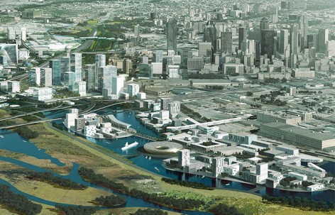
来自ASLA对gooood的分享。
Metamorphous by Mia Lehrer + Associates (MLA),更多请至:Mia Lehrer + Associates (MLA) on gooood
Appreciation towards ASLA for providing the following description:
“这个方案是否会被付诸实践也许并不是那么重要。有些情况下你必须以深思熟虑来换取小小的进步。”
——2015年评审委员会
“Will it be built? That may not be important. Sometimes you have to have far-reaching thoughts to be able to take tiny steps.”
– 2015 Awards Jury
项目陈述 PROJECT STATEMENT
达拉斯与Trinity河之间高速路网密布,川流不息的道路两旁皆是无人问津的荒地。这片区域如同护城河般环绕着城市,截断了城市与自然河岸的联系,让下城空间在Dealey Plaza戛然而止。本方案试图在此打造一个充满活力的线性城市空间,重新建立达拉斯下城与Trinity河之间的联系。
The area between the City of Dallas and the Trinity River Corridor is currently dominated by highways and underdeveloped land. This zone forms a moat around Dallas, truncating downtown at Dealey Plaza and severing the city from the waterfront. This planning vision seeks to connect downtown Dallas and the Trinity River Corridor and to re-envision the zone between them as a vibrant new linear city.
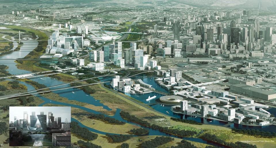
△以水为核心的设计,达拉斯与 Trinity River被川流不息的高速路与无人问津的荒地所阻隔,本案将会把两个彼此脱离的区域重新联系起来,创造一个极富活力的线性都市区域。
WATER-RICH SCHEME, Between Dallas and the Trinity River is an area dominated by highways and underdeveloped land, forming a moat that truncates and severs the downtown from the waterfront. This plan connects the two, and creates a vibrant linear city.
Photo Credit: OMA / MIA LEHRER + ASSOCIATES
项目说明 PROJECT NARRATIVE
达拉斯与Trinity河之间高速路网密布,川流不息的道路两旁皆是无人问津的荒地。这片区域如同护城河般环绕着城市,截断了城市与自然河岸的联系,让下城空间在Dealey Plaza戛然而止。
基础设施阻碍了下城空间的进一步扩张以及与Trinity河流域的连接。作为达拉斯城区内环路南线一部分的两条高速道路分割了场地,计划中的基础设施扩张工程“马蹄铁”项目以及新Trinity河滨河路的建设将进一步增加穿越型交通的流量,而无论是达拉斯下城城区抑或场地本身却都将一无所获。本方案试图在此打造一个充满活力的线性城市,重新建立达拉斯下城与Trinity河之间的联系。设计团队摒弃了在邻近下城区域扩张基础设施系统的计划,希望通过升级现有的12号高速公路提供一个绕过下城区域的新路径,疏导车流,缓解I-35以及I-30的交通压力,最终消解新建道路的必要性。此外,设计还移除了基地内的部分高速路上下口坡道,解放更多的土地以供开发利用。
在基于前期对场地现状的全面调查与分析,以及权衡了各种潜在的规划干预措施后,设计团队最终确立了这个方案。设计团队也对现状水源的水文条件数据和信息进行了收集、分析,并纳入了整个设计之内。此外,他们还考虑到了包括街道、人行道和公共交通系统在内的交通运输系统在现在和未来的潜在发展状况。而设计团队对达拉斯的多次探访不仅让他们身临其境,切身感受城市的现状,同时也为设计团队提供了多次与经验丰富的业内人士交流、讨论的机会。
在这个重新连接达拉斯与河流,并最终实现应对洪涝和干旱季节的弹性设计中,多样化的水岸处理策略根据Trinity河流域的具体情况散布在河流沿岸。基地内的系统设置着重于减轻Trinity河分洪河道的压力,并通过修复其子流域重现足以调、滞、续水的湿地区域,引导雨水自然宣泄,降低洪涝发生的几率。
在重整与修复流域内的集水区与涵洞之后,这条古老的河流将成为沿滨河大道延伸的生态廊道。这个全新的生态区域提升了沿岸地块的价值,将毗邻下城的区域打造为极富吸引力的休闲场所,为未来的开发打下了坚实的基础。
或从空中飞越、或沿地下穿行,四条步行廊道横跨了I-35和铁道系统,连接着城市与河流。在基地的南北两侧,新建的步行桥直通达拉斯快速公交系统的站点。而在中心区域,Dealey广场以及位于Houston和Jefferson的两座高架桥则经过改造,成为河流与城市的连接点。
在基地之内,两个相切的弧形道路在界定出开发区域,为城市与河流提供全新连通路径的同时,也成为了新河道的孕育之地。两道弧线与重焕活力的河流以及滨河大道相遇、分离,串联起一系列的文化场馆和室外活动空间,成为了南北向延伸、支撑起整个项目的支柱。
从南侧的岩岛到北侧的设计创意区,三三两两的城市岛屿点缀在这条“支柱”之上。各有特色的岛屿统领着其周边区域,形成了丰富的层次和多样化的功能区域划分。
本规划方案的落成将极大的改善达拉斯城市与Trinity河流域的连接状况,将这片无人问津的场地转化为充满活力与生机,前途无可限量的城市空间。
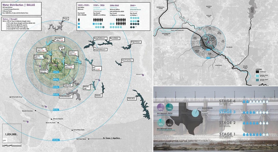
△ 与水共生的新策略,长期被干旱所困扰的德克萨斯不断的从越来越遥远的水源地获取水源,达拉斯试图带领德州走向更积极的水资源保护与再利用策略。
LEADING THE WAY WITH WATER IN TEXAS, Droughts continue to plague Texas, and water is continually sourced from farther and farther away. Dallas is attempting to lead the state of Texas towards more aggressive water conservation and reuse strategies.
Photo Credit: OMA / MIA LEHRER + ASSOCIAT
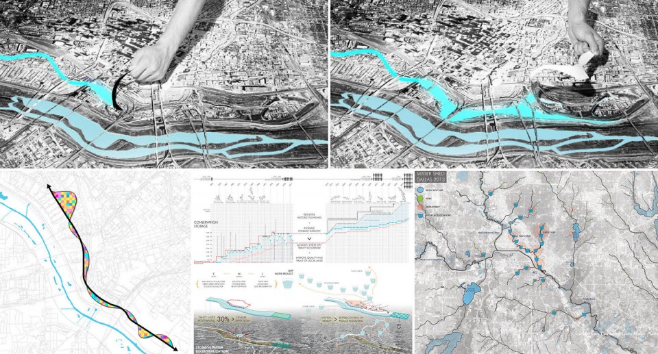
△ 重建城市与水源的连接,在这个重新连接达拉斯与河流,并最终实现应对洪涝和干旱季节的弹性设计中,多样化的水岸处理策略根据Trinity河流域的具体情况散布在河流沿岸。
RECONNECTING THE REGION TO WATER, The strategy for reconnecting Dallas to its river, and ultimately achieving resiliency from both flood and drought events, proposes a diverse and distributed range of water projects throughout the Trinity River Watershed.
Photo Credit: OMA / MIA LEHRER + ASSOCIATES
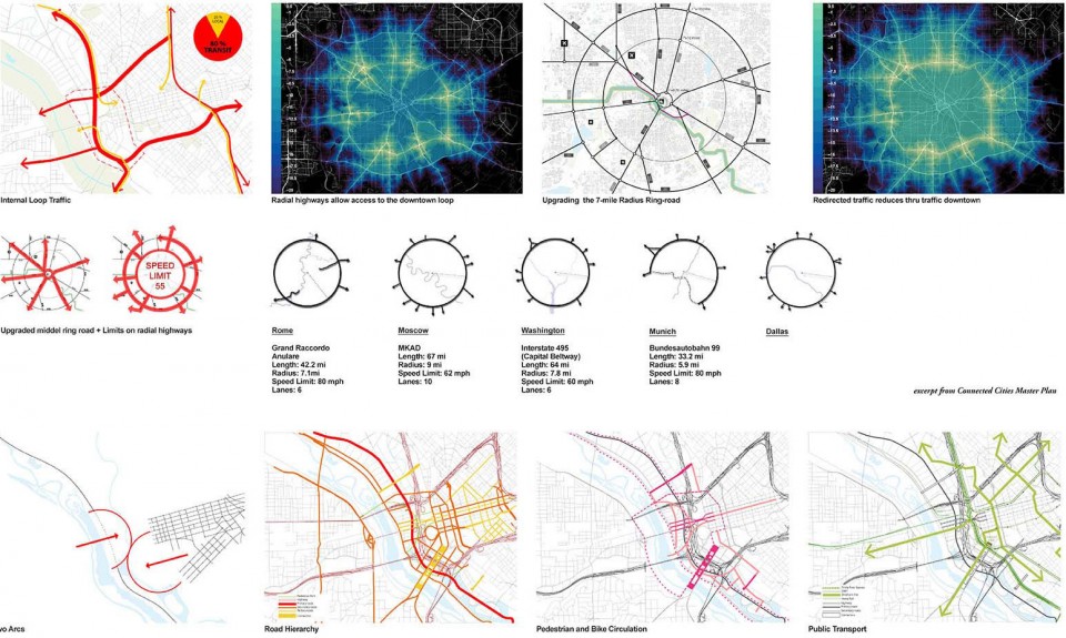
△ 河流与移动性,两条拱形道路连接了城市与河流。而在其中,主次分级清晰的路网系统为沿堤吧和河岸延伸的地块开发建立了明确的框架。
WATER & MOBILITY, Two new arc-shaped roads provide connections between downtown and the Trinity River. Within the loop roads, a grid of primary, secondary and tertiary streets build the framework for development of new properties along the levee and riverfront.
Photo Credit: OMA / MIA LEHRER + ASSOCIATES
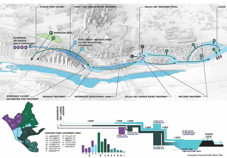
△ 水文系统,基地内的水文系统设置着重于减轻Trinity河分洪河道的压力,并通过修复其子流域重现足以调、滞、续水的湿地区域,引导雨水自然宣泄,降低洪涝发生的几率。
HYDROLOGICAL SYSTEM, The hydrologic system is re-designed to relieve pressure on the Trinity Floodway and reduce risk of flooding by unearthing the Trinity River sub-basin and visibly capturing, treating and redirecting stormwater through the site.
Photo Credit: OMA / MIA LEHRER + ASSOCIATES
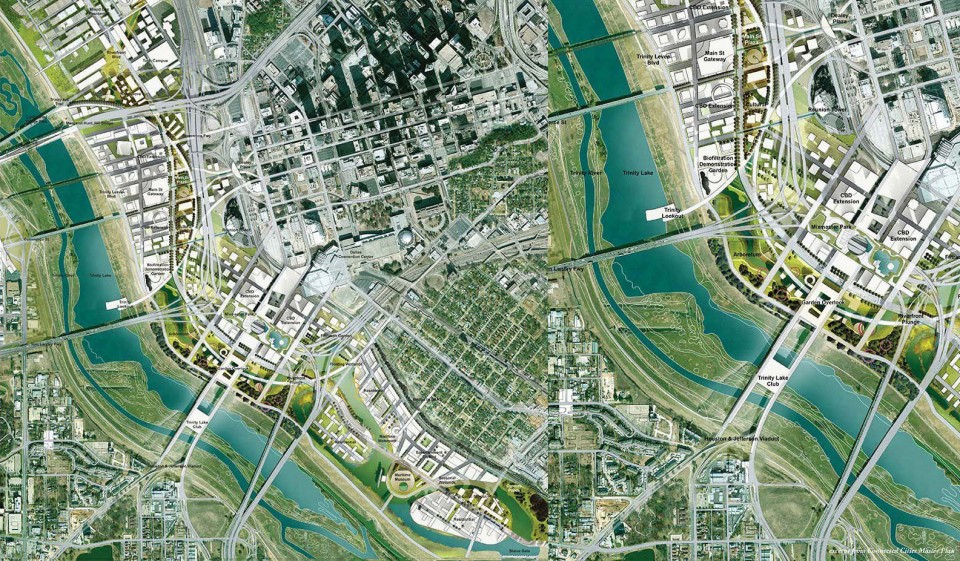
△ 分洪策略,在重整与修复流域内的集水区与涵洞之后,这条古老的河流将成为沿滨河大道延伸的生态廊道,不仅提升沿岸地块的价值,也将毗邻下城的区域打造为极富吸引力的休闲场所,为未来的开发打下了坚实的基础。
RIVER FLOODWAY PROCESSION, Daylighting and filtering existing watersheds and culverts reconstitutes the Old Trinity River, creating a new ecology that is the foundation for development, increasing property values and establishing a new, legible amenity zone adjacent to downtown.
Photo Credit: OMA / MIA LEHRER + ASSOCIATES
△ 多样化的滨水体验,多样化的雨水引流系统将提供独特的滨水体验,激活城市空间。这个与水处理以及生物栖息地结合的雨水处理系统将运送、过滤、滞蓄水源,并最终将其引送至Trinity河流的分洪河道。
CREATING WATER EXPERIENCES, Various inflows of stormwater activate the urban area through uniquely designed water experiences. In combination with water treatment and habitat creation, this extensive system conveys, filters, stores, and eventually releases water back into the Trinity River Floodway.
Photo Credit: OMA / MIA LEHRER + ASSOCIATES
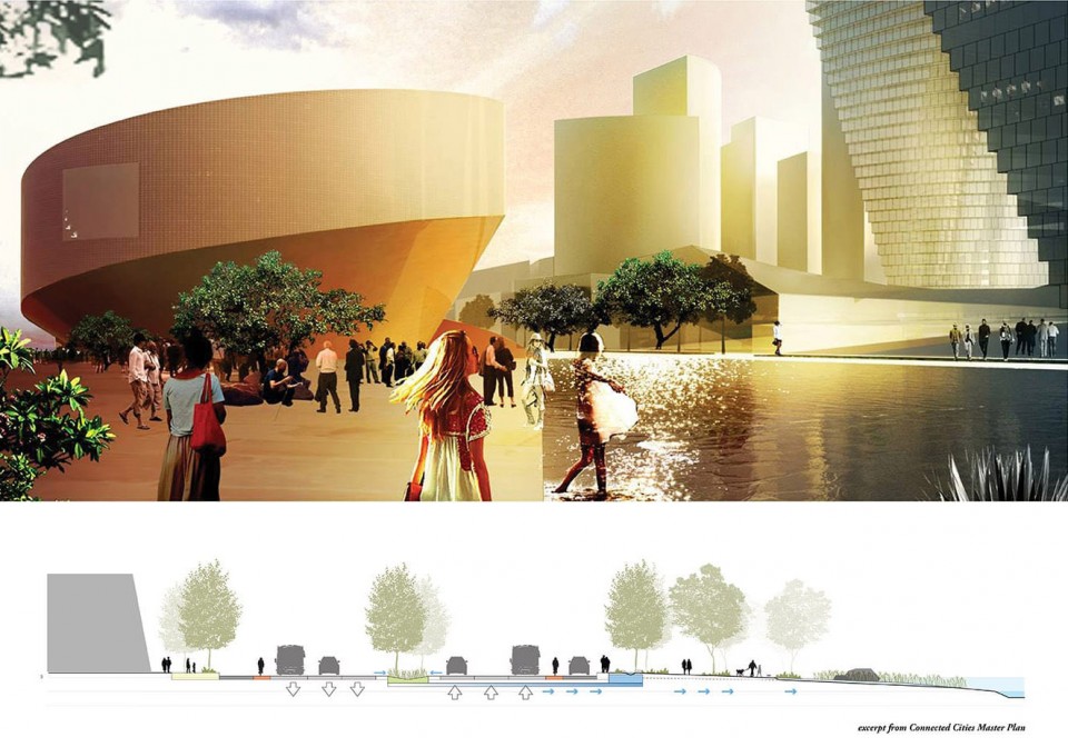
△ 环境、社会与经济效益,水质的提升将有助于提升当地生态与公众健康质量,减少洪涝灾害,修复生态栖息地,改善步行、自行车道路系统。地块经济价值的提升也将减小河堤与城市雨洪系统管理维护方面的花销。
ENVIRONMENTAL, SOCIAL & ECONOMIC BENEFITS, Local ecology and public health is enhanced through improving water quality, reducing floods, restoring habitats, and improving pedestrian/bicycle circulation. Property values increase and maintenance costs associated with the levee and city stormwater decrease.
Photo Credit: OMA / MIA LEHRER + ASSOCIATES
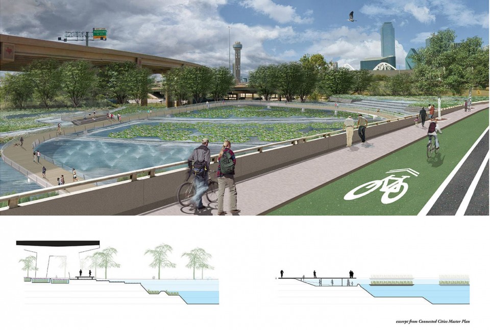
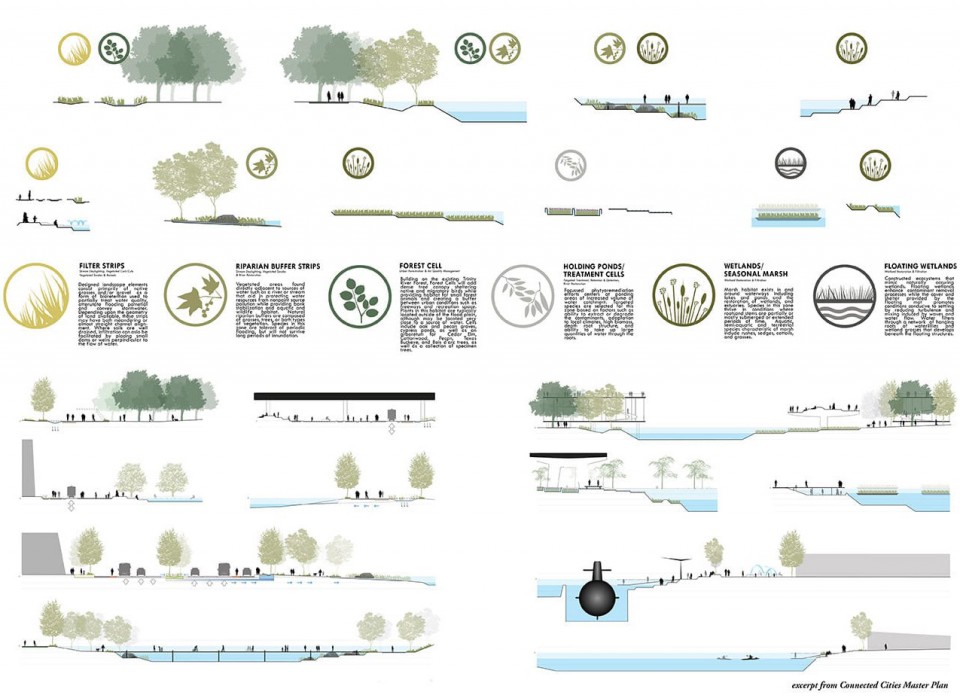
△ 过滤池,运用生物过滤技术与植物修复技术,用于滞留、提升水质的过滤池将成为湿地区域的重心所在。
TREATMENT PONDS, The implementation of treatment ponds focused on retention, detention and increased water quality incorporating bio-filtration and phytoremediation techniques are centered at ponding areas of increased volume of water catchment.
Photo Credit: OMA / MIA LEHRER + ASSOCIATES
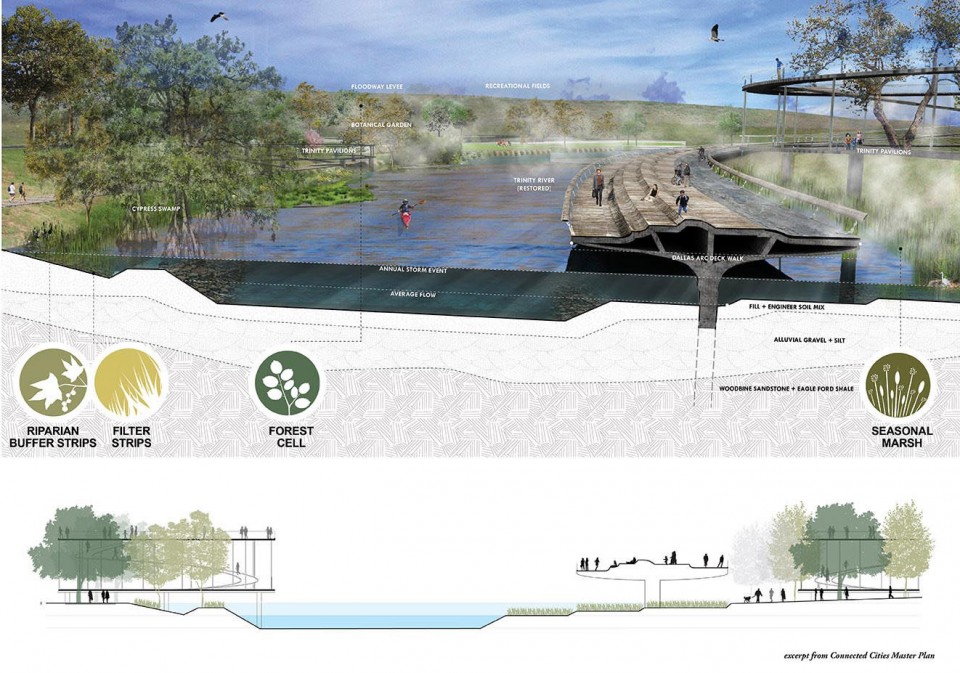
△ 滨河缓冲带,随着流速的减慢水线将慢慢上升,而滨河缓冲带和人工湿地被引入至系统中,增加过滤的效率,同时稳固河堤,为野生的水、陆生物提供栖息地。
RIPARIAN BUFFERS, As the volume of water gradually moves through the site and increases, riparian buffer strips and constructed wetlands are introduced to increase filtration while providing bank stabilization and aquatic and wildlife habitat.
Photo Credit: OMA / MIA LEHRER + ASSOCIATES
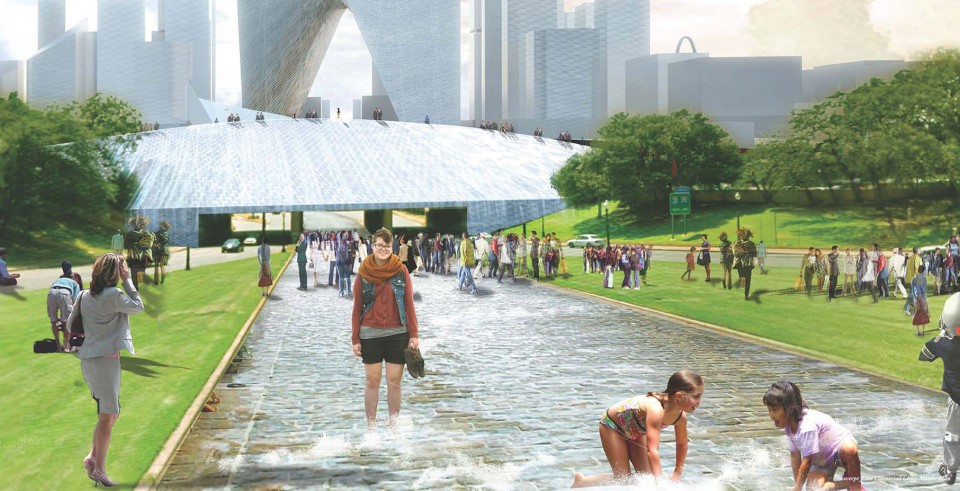
△ 戏水之所,雨水沿着一系列的小河道层层跌落,成为了沿主街、弧形道路和滨河大道延伸的线性开放空间。而散布在滨河大道上的若干个交汇口则成为了居民们欢聚、戏水的最佳场所。
A CELEBRATION OF WATER, Stormwater runoff cascades through a series of runnels, creating a linear open space that parallels Main Street, the Trinity Arc, and Riverfront Boulevard. Intersections along Riverfront Boulevard become places for residents to gather and celebrate water.
Photo Credit: OMA / MIA LEHRER + ASSOCIATES
The area between Dallas and the Trinity River Corridor is currently dominated by highways and underdeveloped land. This zone forms a moat around Dallas, truncating Downtown at Dealey Plaza and severing the city from the waterfront.
The primary obstacle to Downtown’s extension into the site and potential connection to the Trinity is infrastructure. The two highways that currently cut through the site form the southern portion of the city’s three-quarter-mile inner ring road. Currently planned expansions to this infrastructure—the “Horseshoe” project and the new Trinity River Parkway—will further clog an already saturated area with more primary roadways that act as pass-throughs rather than serving either downtown Dallas or the site itself.
The goal of this master planning effort is to connect downtown Dallas and the Trinity River Corridor, and re-envision the zone between them as a vibrant new linear city. Rather than pursuing a path of infrastructural escalation directly adjacent to Downtown, this master plan enhances the existing Highway 12 to create a new ring-road and provide a more appropriate downtown by-pass, alleviating the traffic demand along I-35 and I-30 and eliminating the need for new infrastructure. This approach also allows for the strategic removal of access ramps within the site, freeing land for development and opening the possibility for new connections.
The Connected Cities Master Plan was based on extensive analysis of existing conditions and the weighing out of various potential planning interventions. Hydrologic data and information on existing water conditions was collected, analyzed, and incorporated into the plan. Extensive analysis was also conducted on existing and potential transportation infrastructure, including streets, sidewalks, and public transportation networks. Various site visits to Dallas provided the planning team with an on-the-ground perspective of existing city conditions, as did collaborative meetings with City affiliates and other experienced practitioners.
The strategy for reconnecting Dallas to its river, and ultimately achieving resiliency from both flood and drought events, proposes a diverse and distributed range of water projects throughout the Trinity River Watershed. The system within the project area is designed to relieve pressure on the Trinity Floodway and reduce risk of flood by daylighting the Trinity River sub-basin to create a re-imagined river’s edge that captures, treats and redirects stormwater through the site.
Daylighting and filtering existing watersheds and culverts reconstitutes the Old Trinity River to create a new ecological spine along Riverfront Boulevard. This new ecology provides a foundation for development by increasing property values and establishing a new, legible amenity zone adjacent to Downtown.
To connect across I-35 and the railway, four strategic interventions stretch over and under them. At the North and South, new pedestrian bridges provide access to key DART stations. Closer to Downtown, Dealey Plaza and the viaducts at Houston and Jefferson are transformed to provide new gateways into the site.
Within the site, two arc-shaped loops define development, creating new connections between downtown Dallas and the Trinity and framing the new river. Where the two arcs intersect the rejuvenated waterway and Riverfront Boulevard, a chain of cultural venues and outdoor amenity areas establishes a central spine from north to south.
Along the spine, an archipelago of urban islands stretches from Rock Island at the south to the Design District at the north. Each island is a unique programmatic mix linked strategically to the areas that surround it.
If implemented, this master plan will drastically change the city of Dallas’ connection to the Trinity River Corridor, and help to establish a more vibrant and usable urban area between them.
PROJECT CREDITS
Lead Designer:
OMA / Mia Lehrer + Associates (MLA)
Local/Consulting Landscape Architect: Kevin Sloan Studios
Traffic Engineer: Mobility in Chain
Sustainability Consultant: RWDI
Hydrology Consutlant: Royal Haskoning DHV
Renderings: Tegmark / Mia Lehrer + Associates (MLA)
MORE: Mia Lehrer + Associates (MLA),更多请至:Mia Lehrer + Associates (MLA) on gooood




设计滨水河道时候也要考虑潜水舰娘的感受
这里都能看见舰娘
堤坝 的“坝”写错了,写成“吧”了。不过编辑英文水平还是不错的,肯定一下!
ps:如果你老板看到了,给你升职加薪,不要忘记我叫雷锋!或者给我发个红包也可以