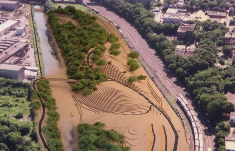
“An example of what we can and should be doing in all cities: replacing a verypolluted area with a native landscape. They are thinking about the process ofconstruction and linking analysis and planning to design and construction. Acomprehensive approach to health issues, which is hard to do. There was a lotof community involvement. Wonderful phasing diagrams. ”
—2011 Professional Awards Jury
“一个我们可以并且应该在所有城市实施的案例:把一个污染严重的区域恢复成原生景观。将分析、计划和设计施工在建设过程中战略性的联系起来。全面的考虑健康问题,让大量的社区参与其中,配以绝妙的发展性图说。”
2011年专业奖评审委员会
By Landscapes of Place, LLC, Mequon, WI,更多请至: Landscapes of Place, LLC, Mequon on gooood
Image © Landscapes of Place, LLC & Marc C. White &Nancy M. Aten
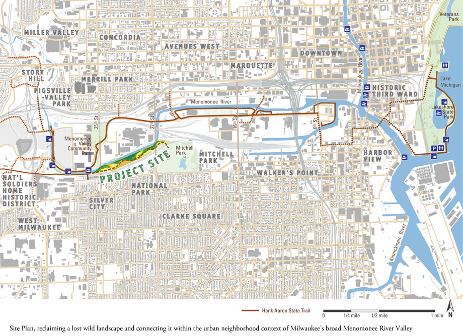
▲总平,恢复场地野生胜景,并将其余城市道路网络紧密相连。
梅诺米尼山谷规划是一个提升城市环境和生境,恢复景观野性和趣味性,以谦逊的态度对待生态的绝佳案例。将河流一侧受到污染的场地转化为一个野生的,健康的可供人们使用的公共场所。计划使得在恢复和教育的共同作用下,场地得到社区的重视。
场地沿着一条人们很少看到也不方便到达的河流,这里从环境和野生动物的角度看,却又是一个遭受160年摧残的场所。线性的场地面积共25英亩,一侧是诺米河,一侧是铁路,其离城市中心地带仅两英里,具备巨大的潜力成为一个邻里使用的公共场所。该项目隶属于一个140英亩旧工业土地的复兴计划。规划力求在这篇土地恢复绿色空间,制造就业机会。全力达到可持续发展系统—-生态,经济,社会。
目标及目标细分
该项目要在城市里创造一个可接触的“野生环境”以治愈土地和社区。将受到不可逆影响的土地和水文条件转化为符合当地乡土,适应新的城市环境,并可以让社会全面参与的生物多样性拼贴景观:比如森林、草原和暂时性湿地。(1)生态性。这是最基本的。要恢复完善的,可持续健康发展环境,让动物能在这里的演进性生存。规划具有挑战性的在城市中提供生态环境和动物栖息地,植入一个“可管理”的计划,确保场所的发展和运转。(2)学习。向生态,环保学习。(3)自然的内在价值。最大限度的保证生物多样性的栖息地和物种种类。在少有的生态系统中实施,比如橡树草原。(4)野外。这里是一个值得人们探索发现,学习观赏的神秘场所。(5)喜悦。人们直观的感受这里的变化,健康。并喜欢上独一无二的这里。
发展分析和步骤
密尔沃基一家全国闻名的环境教育和市民科学机构—-城市生态中心将在场地上建立他们的第三个分构。他们的参与是这个项目的关键,体现大规模环境恢复过程中教育的参与性。 景观建筑师在前期对河流的体验影响规划的细节,特别在恢复场地非生境有关方面的有效方法和技术上。 自然历史分析确定了历史悠久的河道、水文条件和历史悠久的植被。根据自然环境的过往历史评估出场地的潜力。对生物多样性及其结构,还有其栖息地,提出建议。教学。为低年级学生安排环路,为高年级学生安排了更长的路线:深入生境斑块和互动的路线。 控制人们的参与密度,使得各种生态斑块联系成一个整体:草原斑块,湿地斑块与森林斑块。日照受地形影响明显。降雨汇水模式的评估影响物种的组合以及建设时间序列。使得在场地中制造微地形来支持各种物种生存。 分析现有植物,获得入侵生物的资料,对植被进行管理并确定一个最佳的办法减少入侵物种。 分析临近的居民区,州内人口最密集的地方,其两英里半的范围内有诸多学校(方便课后来访)。让河流一侧的另外三所学校的学生根据工程的情况有效的参与进场地恢复的过程中。
计划
这是一个生态恢复计划。在生态和对生态具有潜在影响的因素外,计划还传达出一个大多数市民可以感受的自然土地图景。展望、分析和交流的需求将使得这片“新”土地成为一个公共区域,并发展成为与教育机构联合的、真正能够让人们参与其中的,在预算有限的的情况下对未来未知情况下能进行恢复和管理的土地。
用创新的微地形以及改变土壤结构的方法实现从橡树草原逐步演进到森林的过程。9个群落的479种生物都是可以全范围生态管理的。对整个场地实现全面的阶段性指引。新的种植群落可以适应来自河流和降雨的影响。成为季节性野生动物比如候鸟的栖息地和觅食场所。重新繁衍曾经灭绝的两栖爬行动物。场地的丰富层次和灵活性使得物种更丰富,人和景观的互动更多样。计划非常灵活,在演进中淘汰不必要元素。土地管理者的责任(包括收集种子,培育苗圃)要管理和服务整个资源体系,制定程序保证框架得到恢复。
从城市生态学出发,这个项目同时影响了“城市”和“生态”。在城市的河流处建立野外健康的场所,只能步行或骑自行车到达,让人们被自然包围。设计的框架富有艺术性。生态恢复对短期和长期的利益都很重视。设计在城市肌理的重建中发挥了强有力的作用,增强人了与自然的关系并实现二者的长期互利。
Demonstrating the opportunity to strengthen both urban and ecological qualities, the landscape restoration plan for the Menomonee Valley values wildness, delight, and learning with a strong ecological heart. Restoration of desecrated lands to a wild and healthy landscape along a still-resilient river promises transformation of both people and place through the process. The plan both reflects and develops the idea of restoration and education working together to make a place valued by the community.
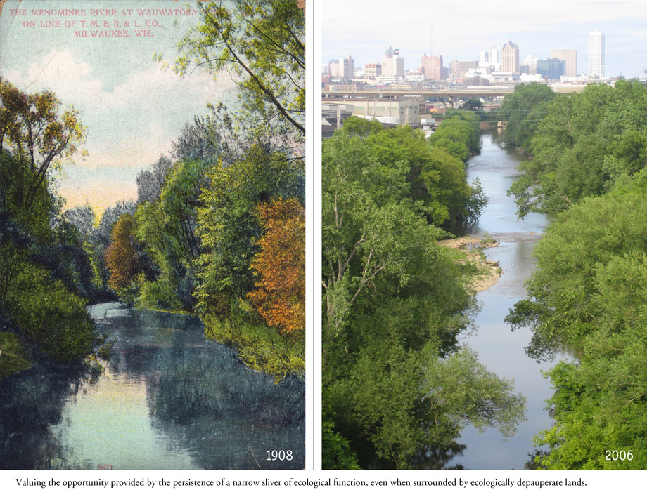
▲即便周边生态性欠佳,也十分重视的为狭长场地提供持续的生境条件。
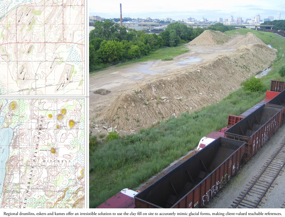
▲区域性的地形和菌落情况提供了不可忽视的解决方案:在场地中制造冰川式微地形。
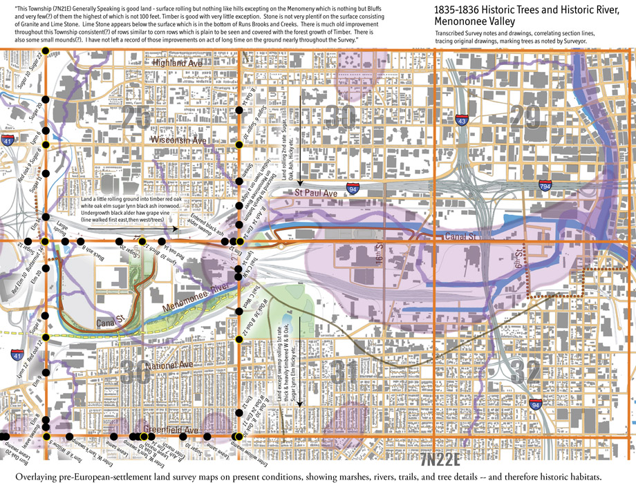
▲叠加过往的历史信息,充分调查历史悠久的栖息地,以及其沼泽,河流,道路,植物情况。
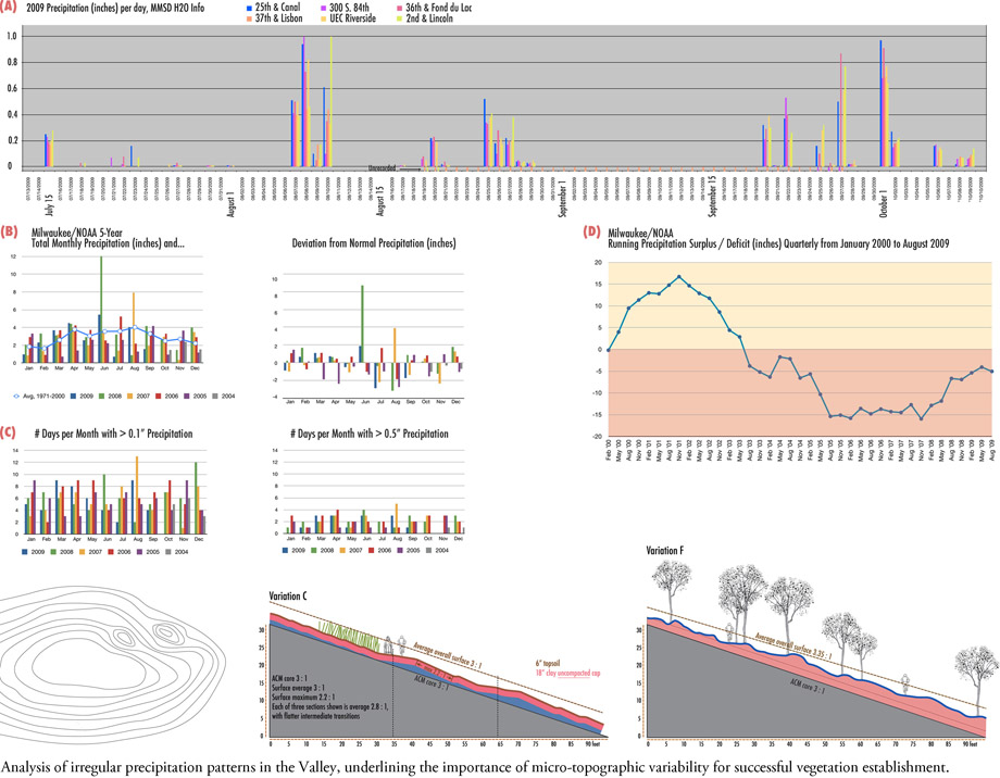
▲分析降雨,利用微地形变化使得新植物群落容易栽植成功。
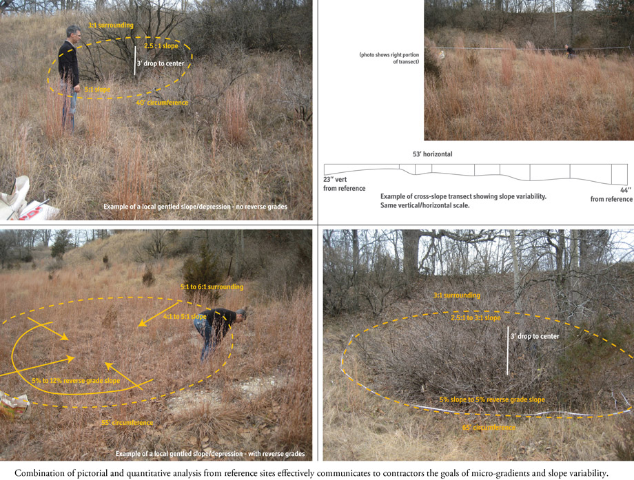
▲网站的分析有效表达,使得工程承包商施工达到梯度和坡度的要求。
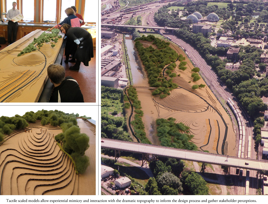
▲比例模型,展现设计过程,收集相关人们的意见。
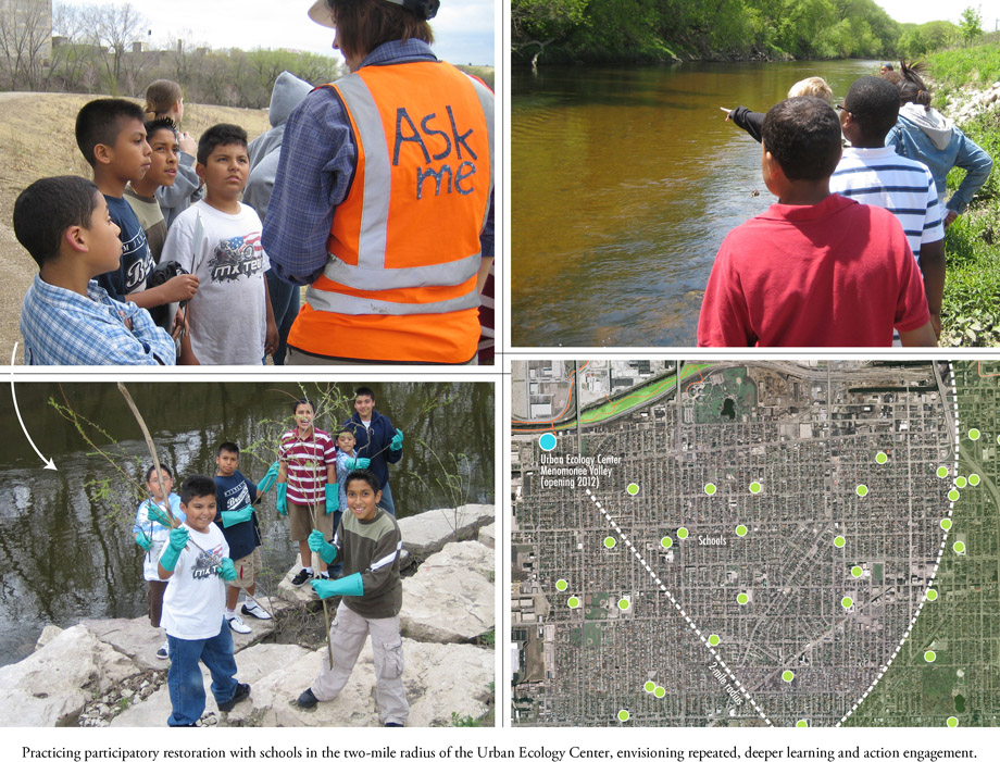
▲让两英里半范围内的学校参与进入恢复过程,进行学习和实际参与。
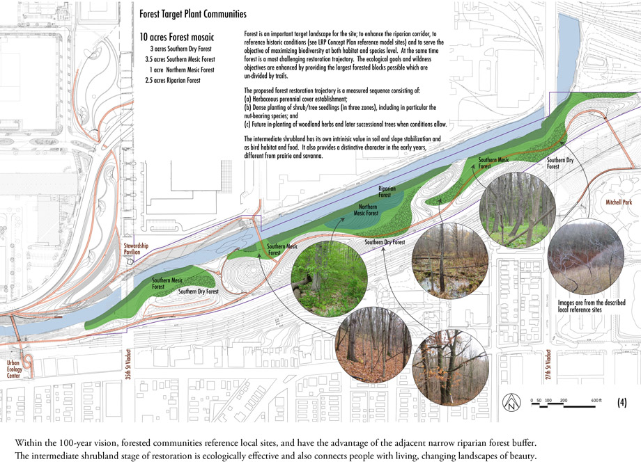
▲百年展望。沿河狭长地段将从灌木林状态恢复成生态效益更大的美丽森林状态。
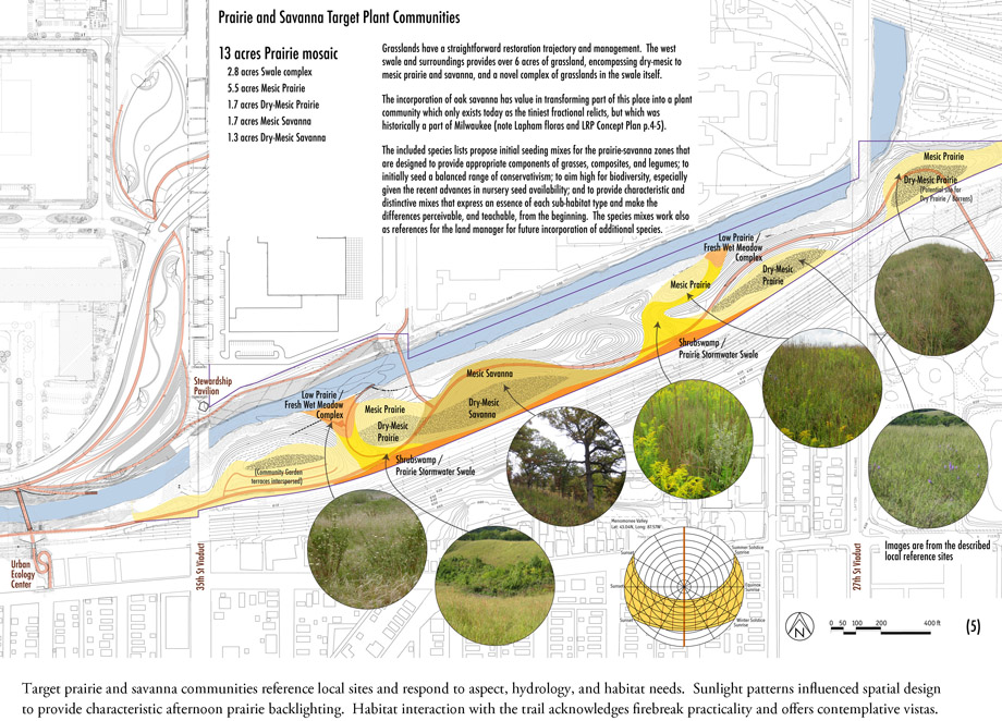
▲根据水文和光照模式,这一区域将是视野开阔的草原和稀树草原。
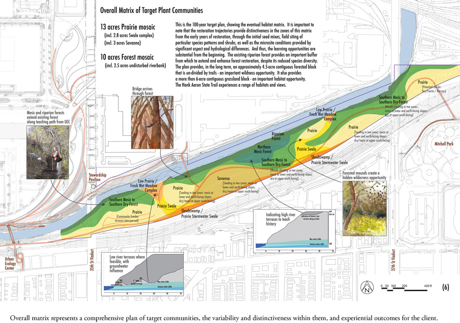
▲一个全面的,具有灵活性和独特性的社区参与计划。
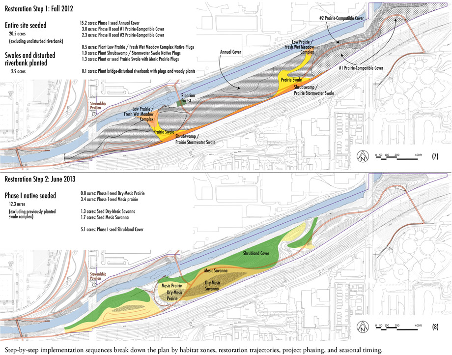
▲栖息地的逐步恢复
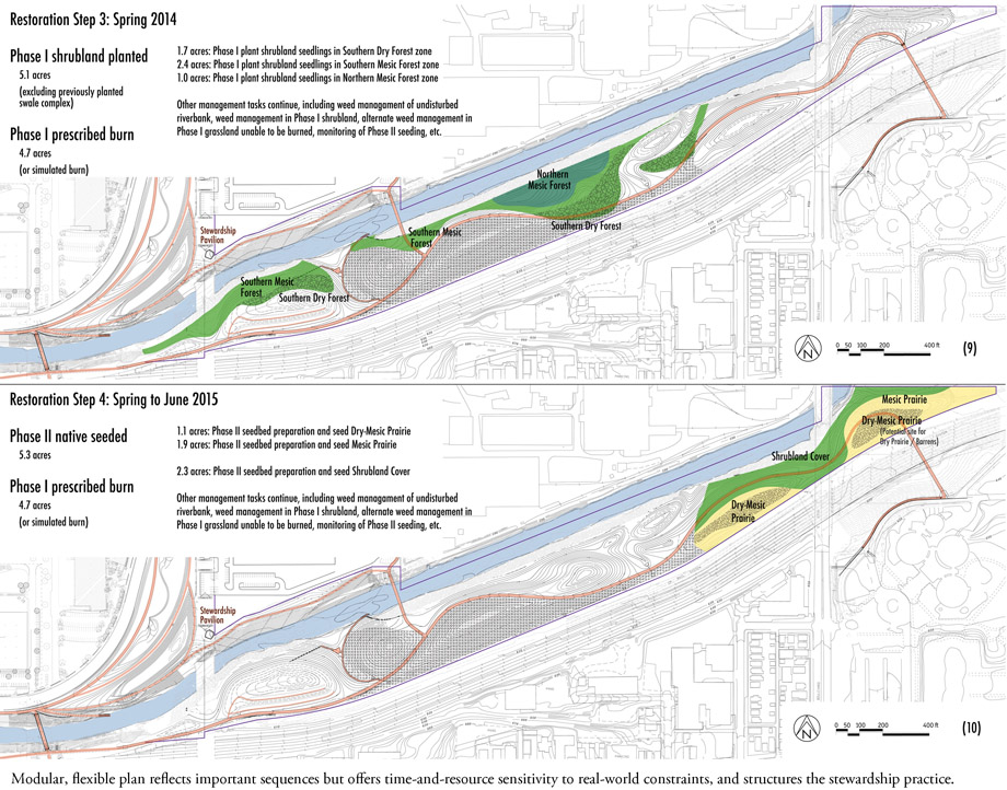
▲模块式的灵活企划反应重要的进程。提供了受现实世界制约的时间,资源,框架灵敏管理方法。
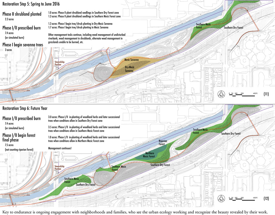
▲重要的是社区和家庭持续的参与,亲眼目睹城市生态工作并认识到其中的美好。

▲被遗忘的荒野景观重现
Here’s some more information:
This is a place along a river that has been both invisible and inaccessible to people for decades. From the perspective of the river and of wildlife, it is also a place that has also been mistreated for a hundred and sixty years. A linear pocket of land is bordered on one side by the urban Menomonee River, in its last natural stretch before confinement downstream by sheet pile walls, and on the other side by the railroad. These 25 acres, two miles from the heart of downtown Milwaukee, provide tremendous opportunity for an idea that has emerged with much time, conversations, inspiring partners and eager neighborhoods: to make a significant wild place in this valley.
This land represents the final project stemming from the Menomonee Valley Master Plan of 2001, which described a revitalization plan for 140 acres of former industrial land. That plan enabled remediation of brownfield conditions, redevelopment of land to reestablish manufacturing jobs, and restoration of green space. Sustainability — ecologically, economically, and for the community, has been foremost in all efforts in the Valley.
Goals and Objectives
In a qualitative sense, the project creates a touchable ‘wilderness’ in the city; healing land and healing community. The overarching goal: to transform the irreversibly altered land and hydrologic conditions to a mosaic of biodiverse landscapes, including forest, prairie, and ephemeral wetland, native to Milwaukee and ecologically appropriate for new conditions, with systemic and meaningful engagement of the community. Guided throughout by the Society for Ecological Restoration’s planning framework, the project refined goals as follows:
1) Ecological Function, incorporating the fundamental ecological goals of recovering ecosystem integrity, health, and the potential for long-term sustainability; to foster successional trajectories toward long-term biotic goals. The plan provides working ecosystem services and habitat for fauna; both highly challenged by urban context. Particular attention is given to a “manageable” plan, that is capable of not ecologically crashing – to ensure there are no big setbacks if public lands management fails temporarily. 2) Learning. To provide from the beginning for deep environmental education, universally inclusive, engaging all senses. 3) Intrinsic Value of Nature. To express sense of place; to maximize biodiversity at both habitat and species level; to make examples of rare ecosystems (such as oak savanna). 4) Wildness. To enable individual discovery, in a landscape that provides clues to a deeper understanding and heightened awareness. To be a place with mystery that you want to explore, linger, hear, see, learn from. 5) Delight. The place looks and feels loved, it is “not like any other park”, and it can be intuitively appreciated. The landscape conveys an intentional, functional, healthy restoration process.
Analyses and Steps Along the Way
The Urban Ecology Center, a nationally-recognized environmental education and citizen science facility in Milwaukee, agreed to establish their third facility on the site. Their involvement is key to this plan, in the evolution of the project goals to fully support their work with neighborhood schools, but also the concept of “education that is participatory in large-scale environmental restoration.”
Our experience across the river in implementing earlier phases of the master plan influenced analyses and details of this plan, particularly related to effective methods and techniques on the ground and in the Valley’s abiotic conditions.
Natural history analysis identified the historic river course, hydrologic conditions, and historic vegetation. Contemporary local and regional assessed reference sites provided the link between historic natural conditions and current potential, and influenced long-term quantitative biodiversity and structure goals for proposed habitats.
Teaching patterns, including trail loops for young students and longer routes for older students, influenced habitat patch arrangement and interaction with the Trail. Comparisons of trail densities in nature centers and other urban trails influenced the stakeholders to reduce trail density, and led to emphasis on developing a significant forested block that is undivided by trail. Fauna habitat needs led to a significant contiguous grassland mosaic (whose scale is grasped from the Trail) that provides ephemerally wet habitats as well as adjacent forests.
Analysis of sun patterns with topographic aspects most directly influenced the habitat mosaic. Rainfall pattern assessments specific to this Valley affect the species mix and timing of species for vegetation establishment. This also led to the plan’s identification of the importance of and practical methods to achieve un-compacted soil profile (to 24″) and microtopographic variability, in furrows and in cradle-knoll conditions, to support species survival. Analysis of biotic conditions within the existing riparian forest, as well as imported weed seed in the acquired fill, led to vegetation management priorities, and the identification of best practices to minimize further weed import.
Analysis of adjoining neighborhoods, among the densest in the state, shows abundant schools within the two-mile teaching radius (facilitating after-school visits). Our experience working with three of those schools in participatory restoration on the other side of the river has influenced the breakdown of steps and the scale of phases that could effectively combine this kind of participation with contracted work.
The Plan
This is an ecological restoration plan. In addition to ecology, and those factors that influence the potential ecology, the plan conveys a vision of natural lands unexperienced by most urbanites. It envisions, analyzes and communicates the practical needs of bringing ‘new’ land into the public domain, of developing truly participatory restoration in conjunction with a key educational facility, and of restoring and managing the land over time with limited and unpredictable budgets.
The plan enumerates trajectories to establish prairie, oak savanna, and eventual forest as long-term goals. It describes innovative methods to achieve un-compacted soil structure and micro-topographic variability. The plan gives thorough descriptions of nine community types with 479 native species, which are viable ecologically, available, and manageable (for example, an initial seeding of 73 species in mesic prairie, with an eventual goal of 110). Reference sites and their floristic quality help give long-term guideposts. Within habitat types, character and species of visual essence are described, and the role of the landscape architect on-site in developing species patterns. Novel native plant assemblages are used in the flashy-river-influenced and stormwater-influenced areas to respond to those conditions effectively. Consideration is made for wildlife food and habitat through the seasons, especially the needs of migrating birds, endangered reptiles known to be on site and amphibians, which are a mainstay of this riparian corridor. Provision for layered, textured, variable, recognizable species and patterns is made to enrich the interaction of people and landscape. The plan incorporates flexibility, phasing, and a blending of contracted and community labor. Responsibilities for the land manager are identified (including seed collection and on-site plant nursery), the structure of a stewardship resources plan is discussed, with opportunities for UEC programming to develop its restoration framework.
In the domain of urban ecology, this project impacts both ‘urban’ and ‘ecology.’ It embeds a wild and healthy place along a still-resilient river in the city, accessible only by walking or biking, big enough to surround you with nature, and without designed structure that can draw attention from the real art… that of life. Ecological restoration values the next-door as well as the far-away. Design plays a strong role in restoration within the fabric of cities, in our next-door places, working out how to strengthen the relationships of people with nature to the sustained benefit of both.
MORE: Landscapes of Place, LLC, Mequon, WI,更多请至: Landscapes of Place, LLC, Mequon on gooood
Via : ASLA








厉害
666
学习一下
2011ASLA专业奖{10}规划设计荣誉奖
An example of what we can and should be doing in all cities~~~学而时习之~~~~~~
bucuo
厉害!
记下