“绿色足迹计划”和“综合规划”根据社区意见和优先选项,为基数据驱动的土地使用方案和开放空间保护创建了框架,并为该县以保护胃导向的发展提供了指导性的工具。这些版图与规划推动了住房的可负担性、多式联运以及基于地方特征的战略的提出,包括创建紧凑的交通节点、小型村落和村庄等。评审团称赞该项目为“一场出色的规划工作,包括在平面设计方面的杰出表现。”
– 2022年评审委员会“The Greenprint Plan and Comprehensive Plan create a framework—informed by community input and priorities—for data-driven land use planning and open space conservation and tools to guide the growth of the county in conservation-oriented development. They promote strategies for housing affordability, multimodal transportation, and place-based character, such as compact transit-ready nodes, hamlets, and villages. The jury praised the project as being an excellent planning effort with a wonderful use of graphics.”
– 2022 Awards Jury来自 ASLA 对gooood的分享。
Connecting People and Landscape: Integrating Cultural Landscapes, Climate Resiliency, and Growth Management in the Low Country | Design Workshop, Inc.
项目陈述
Project Statement
海平面上升和人口增长的影响威胁着南卡罗来纳州Beaufort县的文化景观、视觉资源、干湿生态系统、黑人历史社区、作业水岸以及农业景观。政府发布的两项配套文件,即《2020年Beaufort县绿色足迹计划》和《2040年Beaufort县综合规划》:
1. 在Covid -19各项限制的实施高峰期,利用强大且创新的叙事技巧,实现了与统计相关的社区参与响应。
2. 在政治保守的县内,促进了关于气候变化适应力的讨论,并制定了可被采纳的计划。
3. 概括出了一套生态性的土地利用方法,考虑了海平面上升、水陆野生动物栖息地、视觉资源、遗产树木和文化景观等问题。
4. 创建了一个适用于全国的模型,将气候变化与未来增长模型相结合,并首次协调了以生态和景观作为增长管理主要驱动力的整体土地保护战略。
5. 将场所营造、经济适用房、交通站点开发、小径、水道和步行友好度等各方面的策略纳入了一个此前长期未能解决此类问题的县。
The impacts of sea level rise and population growth threaten Beaufort County, South Carolina’s cultural landscapes, visual resources, wet and dry ecosystems, historically black communities, working waterfronts, and agricultural landscapes. Two companion documents, the 2020 Beaufort County Greenprint Plan and the 2040 Comprehensive Plan for Beaufort County:
1. Achieved statistically relevant community engagement response during the height of Covid -19 restrictions using robust and innovative storytelling techniques.
2. Elevated the discourse around climate change resiliency in a politically conservative county and created adopted plans.
3. Outlines an ecological approach to land use that considers sea level rise, land and water wildlife habitat, visual resources, heritage trees, and cultural landscapes.
4. Creates a model for the country that integrates climate change with future growth modeling and coordinates for the first time an overall land conservation strategy that uses ecology and landscape as the primary driver for growth management.
5. Incorporates strategies for placemaking, affordable housing, transit-ready development, trails, blueways, and walkability in a county that has been reluctant to address these issues.
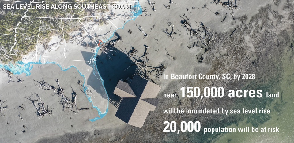
▲东南沿海海平面的上升:Beaufort县的“绿色足迹计划”和“21世纪东南沿海综合规划”为美国东南沿海社区提供了一个典范,涉及公平性、复原力、区域增长、海平面上升、保障性住房、多式联运和乡村保护等一系列问题。Sea Level Rise along Southeast Coast. Beaufort County’s Green Print Plan and Comprehensive Plan for the 21st-Century Coastal Southeast is a model for coastal communities across southeast America that addresses equity, resilience, growth, sea level rise, affordable housing, multimodal transportation, and rural protection. © Emily McCoy / Design Workshop, Inc.
项目说明
Project Narrative
地处低地的县域生态和文化景观
Beaufort县独特的自然和文化景观以及历史建筑环境,对于该县的地方性、生活方式、生态系统健康和经济可持续性都至关重要。气候变化、海平面上升、县城发展和开发压力等因素的叠加作用,将随着海平面的持续增高和人口的空前增长而日益加剧。
在Beaufort县46.8万英亩的土地中,有一半以上是受到潮汐影响的河流、溪流或沼泽,旱地的三分之二位于洪泛区。该县已经收到海平面上升造成的影响,潮汐洪水发生得愈加频繁,根据科学家预测,到2040年,当地海平面将再上升3-7英寸。与此同时,Beaufort县的人口也在猛增,预计至2035年将再增加125%。
“绿色足迹计划”和“综合规划”基于社区的优先选择,为数据驱动的土地利用方案和开放空间保护创建了一个框架,平衡了公平性、文化、历史、生态、复原力,以及尊重环境且以地方为导向的增长和发展。这两项计划还推动了住房的可负担性、多式联运以及基于地方特征的战略的提出。
公共程序和叙事的力量
在Beaufort县的历史上,还从未有过这种将复原力规划、开放空间规划、场所营造和增长管理整合在一起的先例。若要获得充分的认可,展示包含危险的未来、重要的自然环境、合理的分区以及增长管理之间的相互作用有着极为重要的意义,而在一个普遍不遵循土地使用法规的社区,开展这项工作绝非易事。
由景观设计师率领的团队与各方利益相关者会面,以期了解复杂的环境、文化、经济和政治景观以及该地区的历史生态。团队对低地地区的水质、栖息地和文化景观保护进行了广泛的研究,以确定Beaufort县的生态和文化景观的现状及未来轨迹。
团队随后与公众分享了该县的环境故事,并邀请他们参与其中。ArcGIS“故事地图”使用交互式地图和图片向用户介绍了开放空间对于Beaufort县的重要性,并介绍了各种保护策略的工具包,在教育公众的同时,也为公众支持该县传统的土地收购和开发权获得方法之外的工具奠定了基础。
“故事地图”与在线调查形成关联,后者在疫情高峰的背景下,由近1000位居民参与,使规划团队清楚地了解了社区的保护优先事项,以及用于实现不同目标的最适合的工具,包括土地收购、地役权保护、保护性开发激励措施和开发限制。这些优先事项为绿色足迹计划和综合规划提供了信息,并为政府官员提供了他们可以采用的重要措施,从而保护该县的生态和文化景观。
因地制宜的弹性栖息地营造法
景观设计师团队依靠当地的专业知识,基于该土地对于区域生态系统健康的重要性、其文化和历史内涵、可视域以及开发和气候变化带来的直接威胁,确定了保护地的处理方法。
在栖息地保护方面,该计划重点关注高海拔地区,因为这些地区:面临着更大的开发压力;缺乏由联邦和地方为低洼地区(如湿地和洪泛区)提供的其他形式的保护;对于适应因气候变化和人口增长引起的未来生态系统的变化(如沼泽迁移)至关重要。
这两项计划要求建设紧凑的交通枢纽、小型村落和村庄,展现位于低地的小城镇的特征,同时将松树和活栎树的茂密树冠保留在社区的最前端。
规划还提出了以较低成本保护生态系统和服务的方法,并寻求通过保护历史社区和继承人的财产来避免迁移,在Beaufort县,继承人的财产通常是几代黑人家庭共同拥有的未开发耕地。
开发、气候贵族化和文化生活方式的保护
自1960年代以来,许多游客将Beaufort县与长沙滩和种植园时代的废墟联系在一起。但在希尔顿海德岛开发之前,Beaufort县几乎完全是乡村地区,其最具历史意义的文化景观是Gullah/Geechee人的社区、水道、墓地以及其他景观。
发展过程让这些社区中的人们流离失所,这也促使圣赫勒拿岛的Gullah/Geechee社区开始制定规划、法令与合作战略,以杜绝高尔夫球场和度假社区的开发,从而保护乡村的遗产和特征。今天,圣赫勒拿岛还面临着海平面上升的威胁,以及在气候贵族化趋势的背景下,开发商寻求内陆土地所造成的不断增长的压力。
景观设计师团队与 Gullah/Geechee 以及海岛联盟合作,在保护文化生活方式和环境的基础上制定了出了保护的重点对象。在“绿色足迹计划”和经过调整的“综合规划”中,建议利用战略合作伙伴关系、土地恢复、开发限制、税收激励、特殊分区规定和教育计划来保护水道、作业滨水区、农田、风景名胜、历史遗址以及从最初获得自由的奴隶(继承人的财产)世代相传下来的财产。Gullah/Geechee社区的专业知识为地图绘制和一系列战略提供了依据,这些战略不仅将保护Gullah/Geechee遗址,还将保护全县的重要文化景观,包括绿树成荫的道路。
真正的全面规划
综合规划通常会将生活质量和环境保护要素分别置于不同的章节中,而不是考虑二者之间的实际结合。这样的规划只模拟未来的土地使用和增长管理,而不考虑环境优先事项和保护目标。这种短视的观点限制了规划对人类和环境生态系统相互交织的需求的描述。然而,在气候变化和气候贵族化日益加剧的动态环境中,需要有动态的工具来发现和描述历史、文化、环境和经济之间的协同作用——不论是现在还是未来。
“绿色足迹计划”通过绿色足迹叠层为“综合规划”提供信息。绿色足迹叠层源于一个基于优先次序的制图模型,其数据输入和权重参考了“绿色足迹计划”过程中收集的研究和公众意见。优先事项模型是一个“活”的决策工具,旨在绘制并标识出那些在文化景观、水质、重要栖息地、复原力和连通性等保护主题范围内,对社区具有多重益处的土地区域。
绿色足迹优先事项模型是基于ArcGIS Pro的ModelBuilder而创建的,可以根据用户的侧重点,在每个单独的主题和/或多个主题下对保护优先级别进行加权。随着时间的推移,土地面积和优先事项会发生变化,届时可以通过该模型来重新分析数据,以确定新的保护战略区域、新的增长区域以及有利于保障性住房建设的区域。
绿色足迹叠层由综合性的绿色足迹优先用地地图衍生而来,通过使用针对县域的生态和城镇规划横截面来形成一个综合矩阵,为增长管理、分区和开发条例的制定增加了一个保护性的视角。使当地规划者能够根据建筑环境与Beaufort县生态系统之间的交汇点来制定保护、雨水和增长管理的目标和政策。
永久性保护和土地管理集中在乡村和自然保护区。郊区可进行以保护为导向的开发,从而实现紧凑的步行空间和自行车友好型的社区发展,同时在战略上实现经济性,并保护重要的栖息地和生态系统功能。在城市地区,可选择通过引入未来交通节点、低影响的开发、绿色雨水基础设施、保障性住房和城市森林优化管理实践来促进生态健康。
最终,一套全面的、综合性的规划得以完成,既满足了低地县域的独特需求,又创造了一种可用于全国沿海社区的规划方法。
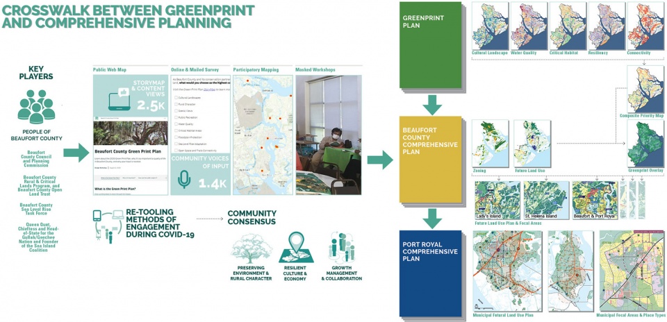
▲绿色足迹和综合规划间的交叉:在疫情高峰期间,规划团队通过在线和现场的叙事活动和众包工具来科普、传播并收集关于Beaufort县神圣而又充满危险的环境的数据和分析,以便为未来的规划提供指导。Crosswalk Between Greenprint and Comprehensive Planning. During the height of COVID-19, the planning team used a mix of digital and in-person storytelling and crowdsourcing tools to educate, engage, and collect local data and insights into Beaufort County’s sacred and at-risk environments to guide future plannings. © Design Workshop, Inc.
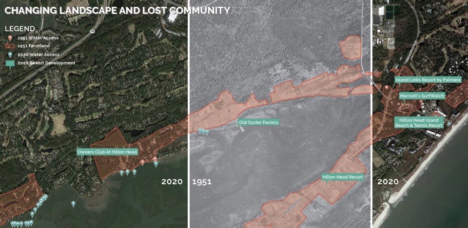
▲不断变化的景观和失落的社区:希尔顿海德岛展现了发展和环境压力可能带来的损失。1951年,该岛有300个居民,大部分是Gullah/Geechee社区的成员,这些社区拥有独特的文化景观。如今,这里已是4万人的家园。Changing Landscape and Lost Community. Hilton Head Island represents what can be lost to development and environmental pressures. In 1951 the island was home to 300 people, mostly members of Gullah/Geechee communities, with distinct cultural landscapes. Today 40,000 call it home. © Google Earth / Design Workshop, Inc.
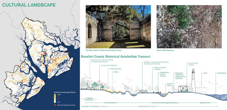
▲文化景观:Beaufort县的文化景观是由人与环境之间的联系所决定的,这可以追溯至美国印第安人的牡蛎壳冢,殖民者的海滨防御工事,以及被奴役的西非人设计和修建的水稻农场。Cultural Landscape. Beaufort County’s cultural landscape is defined by connections forged between people and environment– dating to oyster shell middens raised by American Indians, waterfront fortifications of colonists, and rice farms engineered and built by enslaved West Africans. © Design Workshop, Inc.
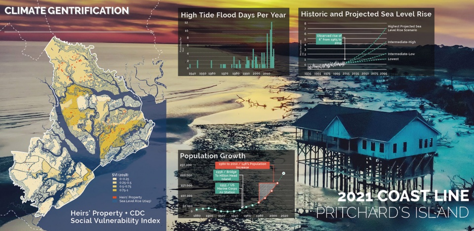
▲防止气候贵族化:随着人口增长和气候变化的压力将发展推向农村高地,前瞻性的土地保护和增长管理战略对于保护脆弱社区和文化景观免受气候贵族化的影响至关重要。Climate Gentrification. Preventing Climate Gentrification: As pressures of population growth and climate change push development toward rural uplands, forward-looking land conservation and growth management strategies will be critical to protect vulnerable communities and cultural landscapes from the impacts of climate gentrification. © Emily McCoy / Design Workshop, Inc.
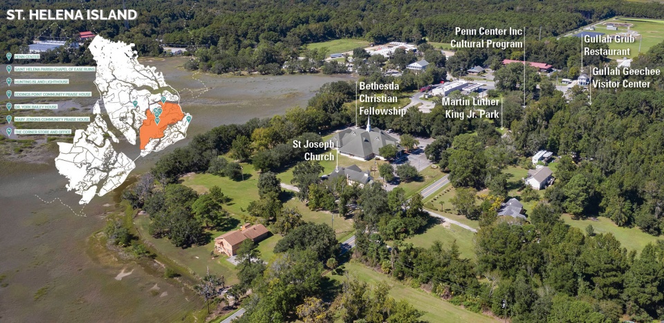
▲圣赫勒拿岛:鉴于希尔顿海德岛Gullah/Geechee社区迁移的事实,圣赫勒拿岛上的Gullah/Geeche社区开始制定规划、法令和合作战略,以保护该岛的文化景观和传统的土地使用模式。St. Helena Island. The displacement of Gullah/Geechee communities on Hilton Head Island prompted the Gullah/Geechee community of St. Helena Island to develop planning, ordinance, and partnership strategies to protect the island’s cultural landscape and traditional land use patterns. © Emily McCoy / Design Workshop, Inc.
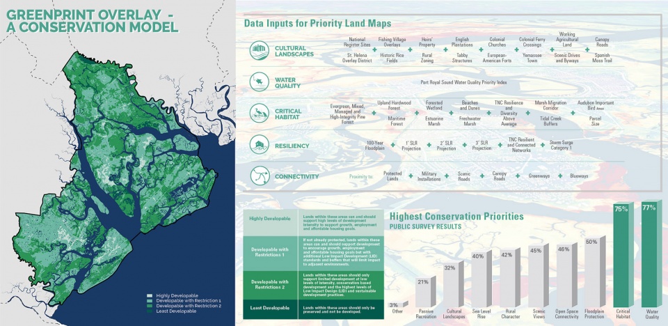
▲绿色叠层 – 一种保护模型。以开放空间价值为驱动力的综合规划:基于广泛研究和参与的优先制图模型推动了“绿色叠层”的发展,为Beaufort县综合规划中以保护为导向的增长管理建议提供了指导。Greenprint Overlay – A Conservation Model. A Comprehensive Plan Driven by Open Space Values: The priority mapping model based on extensive research and engagement led to the development of a “Greenprint Overlay” that guides the conservation-oriented growth management recommendations of the Beaufort County Comprehensive Plan. © Design Workshop, Inc.
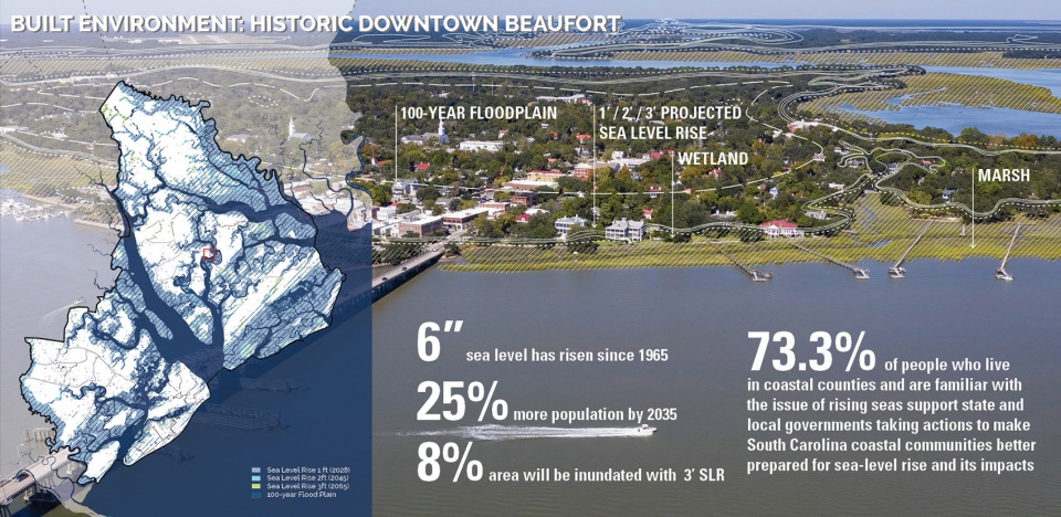
▲建筑环境: 历史悠久的Beaufort城区。Beaufort县46.8万英亩的土地中,有一半以上是受潮汐影响的河流、溪流或沼泽。在该县的旱地中,有三分之二位于洪泛区。自1965年以来,当地海平面已经上升了6英寸。Built Environment: Historic Downtown Beaufort. More than half of Beaufort County’s 468,000 acres are tidally influenced rivers, creeks, or marshes. Of the county’s dry land, two-thirds are in a flood zone. The local sea level has risen six inches since 1965. © Emily McCoy / Design Workshop, Inc.
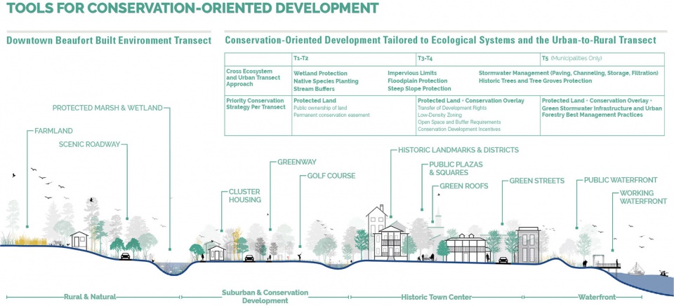
▲以保护为导向的开发工具。扩展工具包: 这些计划考量了以研究为基础的最佳实践,以保护不同类型的土地,并为县工作人员和官员提供了宝贵的信息,使其理解如何支持并推广保护工具包和以保护为导向的增长管理。Tools for Conservation-Oriented Development. An Expanded Toolkit: The Plans considered best practices based on research to protect different types of land, giving county staff and officials valuable information about support for a diverse conservation toolkit and for conservation-oriented growth management. © Design Workshop, Inc.
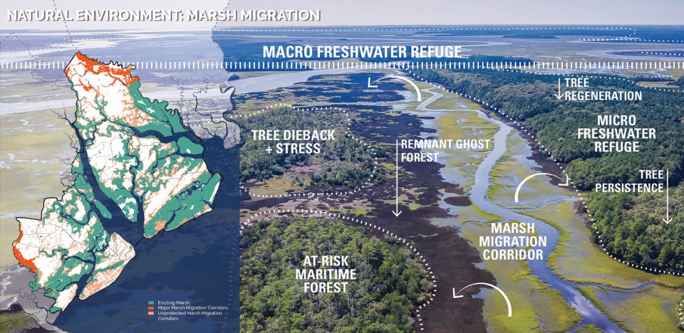
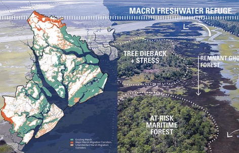
▲自然环境: 沼泽迁移。淡水保护区:在低地地区,由于气候变化造成的“鬼森林”和海岸线后退现象正在以惊人的速度发生。该计划在保护未来的沼泽迁移走廊与维持高地森林和淡水保护区之间取得了平衡。Natural Environment: Marsh Migration. Freshwater Refuges: Creation of ghost forests and shoreline retreats due to climate change are happening at alarming rates in the Low Country. The plan balanced preservation of future marsh migration corridors with protection of upland forests and freshwater refuges. © Brandon Huttenlocher / Design Workshop, Inc.
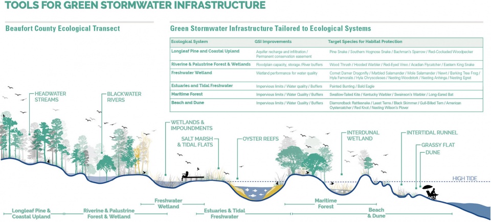
▲绿色雨水基础设施工具。土地管理的动态工具: 新的生态横断面与该县现有的城市-农村横断面同步使用,使地方和地区政府能够根据每个地点的具体自然和建筑环境制定政策。Tools for Green Stormwater Infrastructure. A Dynamic Tool for Land Management: A new Ecological Transect, used with the county’s existing Urban-to-Rural Transect, allows local and regional governments to develop policies that are tailored to each site’s specific natural and built environment. © Emily McCoy / Design Workshop, Inc.
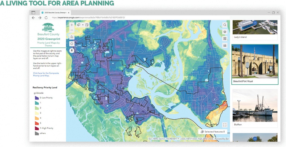
▲地区规划的活工具:优先级地图模型、交互式地图和叙事装置都被用作“活”的工具。随着时间的推移,土地面积和优先事项会发生变化,届时可以通过该模型来重新分析数据,以确定新的保护战略区域。A Living Tool for Area Planning. The priority mapping model, interactive maps and storytelling devices are living tools. As land areas and priorities change over time, data can be reanalyzed through the model to identify new areas for conservation strategies. © Emily McCoy / Design Workshop, Inc.
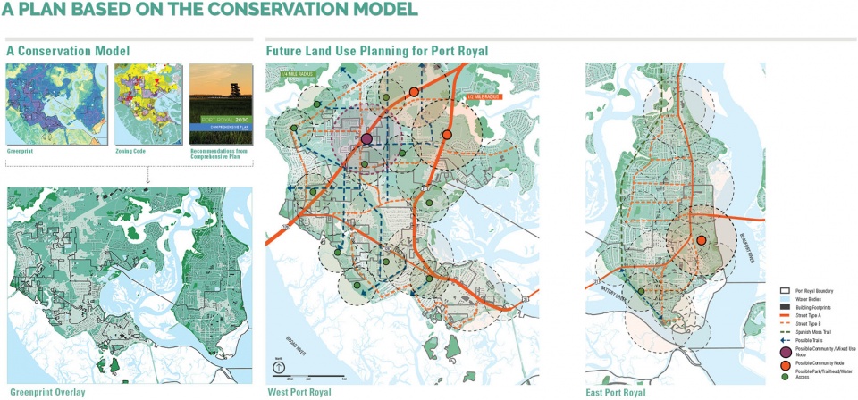
▲基于保护模型的规划:与计划同时进行的,还有一项为皇家港口制定的规划,它整合了“绿色足迹叠层”,展示了以景观为基础的规划方法如何为街区尺度下的增长提供信息。A Plan Based on the Conservation Model. Simultaneous to the process, a plan was created for Port Royal that integrated the Green Print Overlay to demonstrate how the landscape-based approach can inform growth at the neighborhood scale. © Design Workshop, Inc.
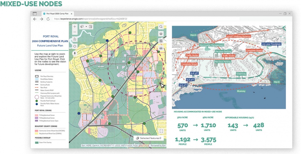
▲混合用途节点:在皇家港口的小区域范围内,规划应对了气候影响,并将“绿色足迹叠层”纳入社区和街区的形式中,以承载和适应步行友好性、保障性住房、连通性、公园、小径以及开放空间的保护。Mixed-Use Nodes. At the small area scale in Port Royal, plans addressed climate impacts and anticipated incorporating the Green Print Overlay into community and neighborhood forms that accommodated walkability, affordable housing, connectivity, parks, trails, and open space protection. © Design Workshop, Inc.
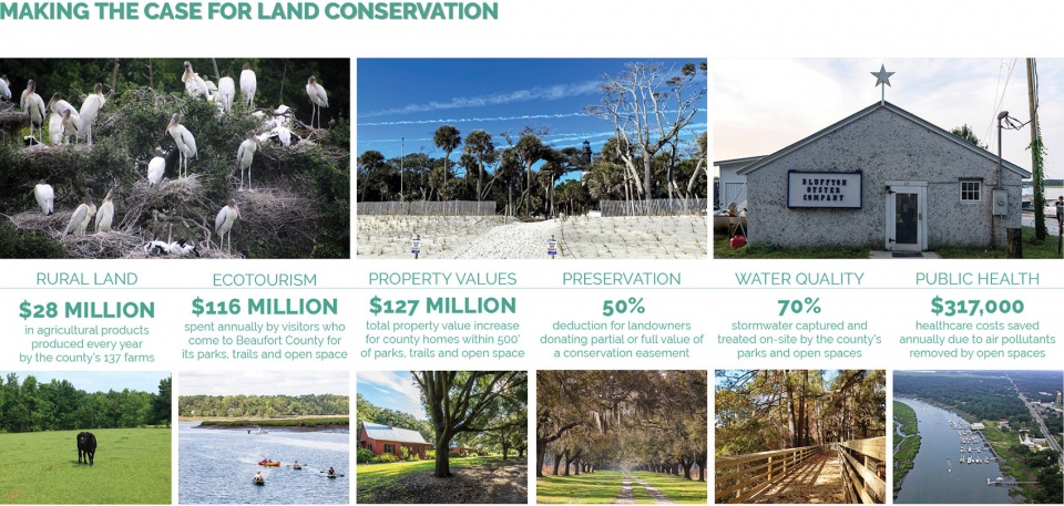
▲为土地保护提供范例: 在一系列复杂的动态变化中,规划过程提供了一个让社区就土地保护对文化、社会、经济和自然恢复力等多方面益处展开持续对话的机会。Making the Case for Land Conservation: In the midst of these complex dynamics, the planning process was an opportunity to launch a sustained community dialogue about the multi-pronged benefits of land conservation for cultural, social, economic and natural resiliency. © Emily McCoy / Design Workshop, Inc.
Project Narrative
ECOLOGICAL AND CULTURAL LANDSCAPES OF THE LOW COUNTRY
Beaufort County’s unique natural and cultural landscapes, along with its historical built environment, are essential to the county’s sense of place, way of life, ecosystem health and economic sustainability. The combined forces of climate change, sea level rise, growth, and development pressure, will only grow in intensity as sea levels continue to rise and the county’s population continues to grow in unprecedented numbers.
More than half of Beaufort County’s 468,000 acres are tidally influenced rivers, creeks, or marshes. Of the county’s dry land, two-thirds are in a flood zone. Beaufort County is already experiencing the impact of sea level rise in the form of more frequent tidal flooding, and scientists expect local sea levels to rise by another three to seven inches by 2040. At the same time, Beaufort County’s population has skyrocketed and is projected to grow by an additional 125% by 2035.
The Greenprint Plan and Comprehensive Plan creates a framework—informed by community priorities—for data-driven land use planning and open space conservation that balances equity, culture, history, ecology, resiliency and environmentally sensitive growth and place-oriented development. The Plans promote strategies for housing affordability, multimodal transportation, and place-based character.
PUBLIC PROCESS AND THE POWER OF STORYTELLING
Integrating resilience planning, open space planning, placemaking, and growth management had never been done in a cohesive way before in Beaufort County. Showing the interplay between a hazardous future, critical natural environments, appropriate zoning, and growth management was essential to gain acceptance, no easy task in a community generally resistant to land use regulations.
The landscape architect-led team met with stakeholders to develop an understanding of the complex environmental, cultural, economic, and political landscape and the regions historical ecology. The team compiled extensive research on water quality, habitat, and cultural landscape protection in the Low Country to determine the current state and future trajectory of Beaufort County’s ecological and cultural landscapes.
The team then shared that environmental story with the public and invited them to weigh in.an ArcGIS StoryMap used interactive maps and images to walk users through the importance of open space in Beaufort County and introduced a varied toolkit of conservation strategies, educating the public and laying the groundwork for public support of tools outside the county’s traditional methods of land acquisition and purchase of development rights.
The StoryMap linked to an online survey, completed by almost 1,000 residents in the height of COVID-19 restrictions, that gave the planning team a clear picture of the community’s conservation priorities and the different tools—land acquisition, conservation easements, conservation development incentives, development restrictions—most appropriate to achieve different goals. These preferences were used to inform the Greenprint Plan and the Comprehensive Plan and provide public officials vital steps they can take to protect the county’s ecological and cultural landscapes.
PLACE-SPECIFIC METHODOLOGY FOR RESILIENT HABITATS
The landscape architect team relied on local expertise to define methodologies for the identification of conservation lands based on the land’s importance to regional ecosystem health, cultural and historic significance, viewsheds, and the immediacy of the threat posed by development and climate change.
For habitat protection, the plans emphasize higher-elevation lands, given that those areas face greater development pressure; lack other forms of federal and local protection afforded low-lying lands such as wetlands and the floodplain; and will be essential to accommodate future ecosystem shifts—such as marsh migration—precipitated by climate change and population growth.
The Plans call for compact transit ready nodes, hamlets, and villages, which reflect upon small town character of the Low Country, and which allow the pine and live oak canopy to be retained at the forefront of the community.
The plans anticipate methods to protect ecosystems and services at a lower cost and seek to avoid displacement by protecting historical communities and heirs’ property, which in Beaufort County is most often undeveloped acreage collectively owned by generations of Black families.
DEVELOPMENT, CLIMATE GENTRIFICATION, AND THE PROTECTION OF CULTURAL LIFEWAYS
Since the 1960s, many visitors have associated Beaufort County with its long sand beaches and plantation-era ruins. But before the development of Hilton Head Island, Beaufort County was almost entirely rural, and its most historically significant cultural landscape was the communities, waterways, cemeteries, and other landscapes of the Gullah/Geechee.
Development displaced Gullah/Geechee communities, prompting the Gullah/Geechee community of St. Helena Island to develop planning, ordinance, and partnership strategies to prevent the development of golf courses and resort communities there, and to protect their rural heritage and character. Today St. Helena Island faces additional threats of sea level rise, and the growing pressures of developers seeking inland land as part of a trend of climate gentrification.
The landscape architect team worked with the Gullah/Geechee and the Sea Island Coalition to develop a conservation focus that is informed by the protection of cultural lifeways and environmental and cultural preservation. Within the Greenprint Plan and the aligned Comprehensive Plan are recommendations to utilize strategic partnerships, land restoration, development restrictions, tax incentives, special zoning provisions, and educational programs to protect water access, working waterfronts, farmland, scenic views, historic sites, and the properties that have been handed down for generations from original freed slaves (heirs’ property). The expertise of the Gullah/Geechee community informed a mapping methodology and set of strategies that will protect not just Gullah/Geechee sites, but significant cultural landscapes, including tree lined canopy roadways, throughout the county.
TRULY COMPREHENSIVE PLANNING
Comprehensive plans generally silo quality of life and environmental protection elements in separate chapters, rather than considering their realistic integration. They model future land use and growth management irrespective of environmental priorities and conservation goals. This often-shortsighted perspective limits the plan from describing a future that is representative of the intertwined needs of human and environmental ecosystems. However, dynamic environments, where climate change and climate gentrification are happening at a rapid pace, require dynamic tools that find synergies between history, culture, the environment, and economics—now and into the future.
The Greenprint Plan informs the Comprehensive Plan through the recommendation of a Greenprint Overlay derived from a prioritization mapping model, with data inputs and weighting informed by the research and public input collected during the Greenprint planning process. The priority model is a living decision-making tool that aims to map—and highlight—land areas that have overlapping and multiple benefits to the community, within the conservation themes of Cultural Landscapes, Water Quality, Critical Habitat, Resiliency and Connectivity.
The Greenprint prioritization model was built using ModelBuilder in ArcGIS Pro. Conservation priorities can be weighted within each individual theme, and/or across multiple themes, depending on the focus of users. As land areas and priorities change over time, data can be reanalyzed through the model to identify new areas for conservation strategies, new areas for growth, and areas to promote affordable housing.
The Greenprint Overlay, which is derived from the composite Greenprint priority land map, adds a conservation lens to view growth management, zoning, and development ordinances by using county-specific ecological and town planning transects to form an integrated matrix that allows local planners to craft conservation, stormwater and growth management goals and policies informed by the intersection of the built environment and Beaufort County ecosystems.
Permanent conservation and land stewardship is concentrated in Rural and Natural Preserve zones. Suburban areas accommodate conservation-oriented development which allow compact pedestrian and bike friendly neighborhood growth while also strategically enabling affordability and protecting critical habitat and ecosystem functions. In urban areas, there are options for promoting ecological health through anticipating future transit ready nodes, Low Impact Development, Green Stormwater Infrastructure, affordable housing, and urban forestry best management practices.
The result is a comprehensive and integrated set of plans that meet the unique needs of the Low Country, while creating a method of planning that can be used in coastal communities across the country.
More: ASLA; Design Workshop, Inc.








分析图不错
规划项目的分析图真是赏心悦目