海外存知己,天涯若比邻。
在海外专辑分享海外华人的故事。希望这份分享可以让世界更加海阔天空。
第三十四期为您奉上的是学习于美国哈佛大学目前正在波士顿Reed Hilderbrand景观设计事务所公司工作的郝培晨。
看,学。
Why go abroad?
To see, to learn.
在国外遇到了什么让你印象最深刻的事情?
思想的碰撞,辩证的思维,能够坦诚而各抒己见的氛围。
Is there anything happened impressed you the most abroad?
The collision between ideas, The critical way of thinking, the atmosphere that embraces honesty and participation.
最想念祖国的什么?
故乡的海
What do you miss the most about China?
The sea of my hometown.
你会回国吗?为什么?
会,落叶归根,故土难离。
Will you come back? Why?
Yes, it’s hard to leave one’s home forever.
出国后在不同的背景下再看中国是否看得更清晰,有哪些感触?
不会,反而我觉得对中国的认知浅而又浅。回头看至今所学所获,其大多是“术”,即设计手段;而真要得“道”,却需要很长的时间。近年来美国的景观教育一直在强调普遍性,用一个统一的思想,如景观都市主义,生态都市主义等等来解决世界性的问题。在实践中,这种标准往往成了人们惯用的环保标签,但对更为重要的景观建造和技术却一再放松;许多号称运用了这些思想的设计时常以牺牲空间丰富性和可持续性为前提,而忽略了小尺度上人对舒适空间的要求,亦忽略了景观的长期价值,造成了社会资源的巨大浪费。景观设计在某种程度上变成了景观生产,很多看似不错的设计,其生命却不过短短几年。要想重新这些审视问题,便必须重新深入中国文化与生活,去感知属于中国本土的景观需求,而这是身在海外的我难以做到的。
Is it more distinct to view China in a different environment after going abroad? Any thought?
No, instead I feel more ignorant about China as I stayed abroad longer. Most of what I have learned are “skills”, or the methods of design, yet pursuing the “methodology” of design requires a much longer period of my life. In recent years, landscape education in US kept emphasizing universality, using a unified idea such as landscape urbanism or ecological urbanism to solve worldwide problems. In practice, these standards usually become stickers of signifying environmentalism while the long term sustainability as well as a significant tradition of landscape craftsmanship and technology are largely ignored. Some of the designs said using these ideas often sacrifice the possibility of space and design and ignore the comfortness for human body in a small scale. To some extent, landscape design becomes landscape production. Some good looking designs could seldom survive a few years. To rethink these questions in China’s context, revisiting the culture and life of this land is necessary and thus becomes very difficult for people such as me being abroad.
你的学校有哪些教育特点?
哈佛的教育并不要求学生接受某一个或某一类观点,学生会通过接触观点与定位截然不同的课程和老师而做出选择,最后得出属于自己的结论。而设计学院绝并不仅仅是教授设计手段和培养设计思想,更重要的,是帮助学生筛选兴趣、特长、定位、抱负的方式,而这种筛选对于在实践设计领域依旧相对边缘而敏感的景观学科尤为重要。
What are the educational characteristics of your school?
Education of Harvard does not require student to accept a certain kind of idea. Students would interact with teachers and theirs courses holding distinctive messages and choose a position accordingly. The design school of Harvard (GSD) does not merely teach design methodology, but more importantly, it helps students to establish a selection of interests, specialty, position, and ambition, which is very important for acknowledging one’s central task in working as a landscape architect.
你现在工作公司的特色和有趣的地方?
Reed Hilderbrand LLC.,是在美国东岸极具影响力的景观事务所,奉行简约明快的设计风格,其作品与研究在ASLA与BSLA连年获奖。对于设计质量和细节的追求是其立足根本。创始人之一Gary Hilderbrand是GSD景观专业的教授,他的名言“Simplicity is complexity resolved.”从在哈佛的第一年起就深深触动了我。公司十分注重自主研究,每年都会对城市土壤、城市树木、设计表现等话题进行专门研究。这些研究的成果丰富了设计的可行性,保证了公司的建成项目在长期低维护的条件下仍能保持较好的状态。
Can you discuss the characteristics of the company you are working for?
Reed Hilderbrand LLC. is an influential landscape architecture firm in eastern US, pursuing a concise style of design, whose project received awards from ASLA and BSLA through the years. Their persistence in design quality and details established a well-known reputation. One of the founding partners Gary Hilderbrand has committed in teaching at GSD since 1990. His words “simplicity is complexity resolved” has deeply influenced me from my first year at GSD. The firm invests itself in research every year in topics such as urban soil, urban trees, and design representation. These researches expanded the feasibility of its design, help guarantee the projects to keep its designed condition with a relatively low maintenance.
最喜欢的艺术家(绘画音乐电影等广泛范围)是谁?给你创作带来了什么影响?
埃尔·格列柯(El Greco)是我一直很喜欢的画家。他笔下的世界,无论世俗与否,无不渗透着神性中恐惧的一面。即使是最纯净的天堂,也时刻笼罩在异样的昏暗之中。他《托雷多的风景》(现存于纽约大都会博物馆)中的天空,描绘了层云之外,仿佛来自另一个世界的光芒,不禁让人联想到《神曲·天堂篇》中的九重天。其美不在于美之本身,而在于辉煌之下的阴霾,恐惧之中的希望。其景之美并不因地理上的无限而广大,却因想象的无垠而壮丽,是被现实束缚的设计极难达到的境界。
Who is your favorite artist (in wider range such as art, music, movie)? What is the influence?
El Greco is one of my favorite painters. His artistic world, whether or not representing secularity, always implies a heavenly fear. Even the purest heaven is always masked by mysterious dusk. His depictions of sky in View of Toledo (Metropolitan Museum of Art, New York City) illustrated lights from layers and layers of clouds beyond, seemingly suggesting the nine celestial spheres of heaven in Paradiso. Its beauty emerges from the glorious through haziness and the hope through horror. The beauty of this landscape does not exist for its geographical vastness, but is demonstrated through the infinity of imagination. This level of beauty can hardly be practiced by design which is bound by reality.
觉得自己的作品集有哪些迷人的特质?
出国学习的环境是嘈杂的,有太多不同的观点,更有太多先入为主的偏见。我不认为我的作品中有什么深刻的思考,而其中最大的特点就是能够相对客观而谦卑的接受国外教育的内容,在这种前提下,这些作品能够帮助我进行下一步的审视,看到自己的优点与弱点。而要真正对设计有所思考,却可能是一辈子的事情。
What amazing character do your works have?
The environment of studying abroad is very noisy, filled with too many different opinions, and too much first impression without deep understanding. I don’t think my works contains deep thinkings. Maybe one of the features is that these works presented a glance of education abroad objectively. These works could then help me further examine myself. Speaking of deep understanding, it would probably be a lifelong task.
什么时候开始看谷德网的?欢迎你提出建议哦,谢谢。
本科毕业就开始关注,非常喜欢欣赏各种专辑中同龄人的观点,这个难得平台使不同观点的人在保持距离的同时变得理性,从而成功地将各种思想挖掘出来。真诚希望谷德越来越好。
When did you start to follow gooood? Any suggestions?
Since I graduated from college. I specially enjoy reading opinions from people of my age. This unique platform rationalizes people with competitive opinions and hold their distance, yet successfully developed their ideas and present them to the public. I sincerely wish gooood a better future.
作品 Work
再读泰姬陵遗产廊道——连接历史的河流
景观规划,阿格拉,北方邦,印度
指导教师:Rahul Mehrotra
Rethinking Taj Heritage Corridor: A River as Historic Connection
Landscape Planning, Agra, Uttar Pradesh, India
Instructor: Rahul Mehrotra
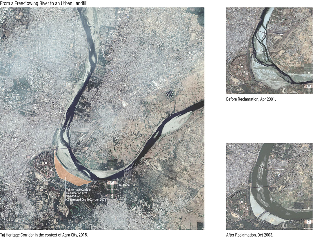
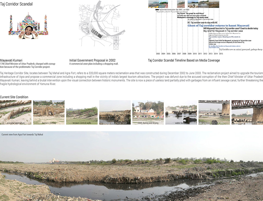
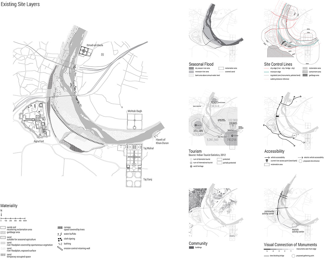
泰姬陵遗产廊道,指的是2002年12月至2003年6月建成的,位于泰姬陵和阿格拉城堡间约32万平方米的填埋地。此填埋工程的初衷是为了升级阿格拉的旅游基础设施,并在印度最具吸引力的旅游景点附近建立一座包括综合商场在内的商业中心。该项目随着北方邦首席部长Mayawati Kumari的腐败指控而流产,在历史建筑重要的视觉联系间留下了一片荒芜的土地。如今这片场地破败不堪,其中一部分被污水沟渠带来的大量垃圾覆盖,进一步危害着亚穆纳河已经十分脆弱的水文环境。
Taj Heritage Corridor site, locates between Taj Mahal and Agra Fort, refers to a 320,000 square meters reclamation area that was constructed during December 2002 to June 2003. The reclamation project aimed to upgrade the tourism infrastructure of Agra and propose a commercial zone including a shopping mall in the vicinity of India’s largest tourism attractions. The project was defunct due to the accused corruption of the then Chief Minister of Uttar Pradesh Mayawati Kumari, leaving behind a brutal intervention upon the visual connection between historic monuments. The site is now a piece of useless land partially piled with garbage from an influent sewage canal, further threatening the fragile hydrological environment of Yamuna River.
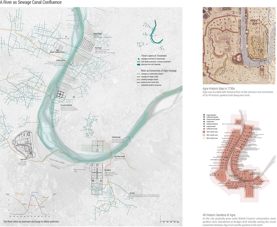
泰姬陵遗产廊道如今的处境进一步增加了河水与阿格拉城堡间的距离,使亚穆纳河在阿格拉城的意向中更加孤立了。阿格拉作为莫卧儿王朝(1526-1857)曾经的首都,建立在以亚穆纳河为门户和连接的45座沿河分布的历史花园周围。随着城市在英国殖民统治下的扩张,大多数花园逐渐被遗弃。现代的桥梁野蛮地切断了阿格拉城堡和其北部许多花园的视觉联系。多年以来,当地的居民、工厂、农田把河流逐渐变作城市的背面与废水的排放地。河流逐渐演变成未处理排污明渠的汇流地,而不再是连接历史遗迹和城市生活的媒介。如今,阿格拉城正试图用分布式污水处理系统(DEWAT)来治理城市中的排污明渠,旨在降低城市排放的污水量。
The current condition of Taj Heritage Corridor site adds on to the isolation of Yamuna River in the image of Agra by pushing river water further away from Agra Fort. Once as the capital city of Mughal Empire (1526-1857), Agra was founded with Yamuna River as the entrance and connection of its 45 historic gardens built along river bank. As the city gradually grew under British Empire’s colonization, most gardens were abandoned as bridges built brutally cutting the visual connection between Agra Fort and the gardens in the north. Over the years, households, factories and farmlands has transformed the river into a sewage dump site and the backyard of the city. The river gradually becomes the confluence of untreated sewage canals instead of a connection of historical monuments and civic life. Currently, efforts are taken by the city to treat the polluted sewage canals through Decentralized Wastewater treatment (DEWAT) system, which aims to reduce the amount of pollutant discharged from the city.
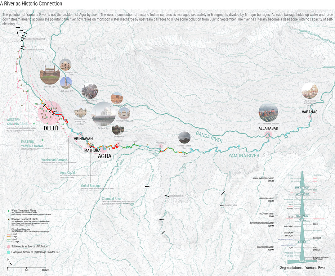
然而,亚穆纳河的污染并不是阿格拉本身造成的。这条联结着印度历史与文化的河流被五座水坝分为六段管理。在亚穆纳河流出喜马拉雅山口处的Dakpathar水坝,96%的河水被引往用于农业灌溉的运河。这使河道尤其在旱季,于很长的区间内难以维持足够的水位,这个区间包括了德里和阿格拉等主要城市。每座水坝的拦截作用使下游的污染物进一步累积,河流不得不依靠每年7月到9月雨季上游水坝的泄洪来稀释部分污染物,让这条河流真正变成了几乎没有自净能力的死河。
However, the pollution of Yamuna River is not the problem of Agra by itself. The river, a connection of historic Indian cultures, is managed separately in 6 segments divided by 5 major barrages. At Dakpathar Barrage where Yamuna river exists the Himalayas, 96% of water is directed into irrigation canals for agricultural use, which makes a long stretch of the river including Delhi and Agra suffers from insufficient flow in dry season. As each barrage holds up water and force downstream area to accumulate pollutant, the river now relies on monsoon water discharge by upstream barrages to dilute some pollution from July to September. The river has literally become a dead zone with no capacity of self-cleaning.
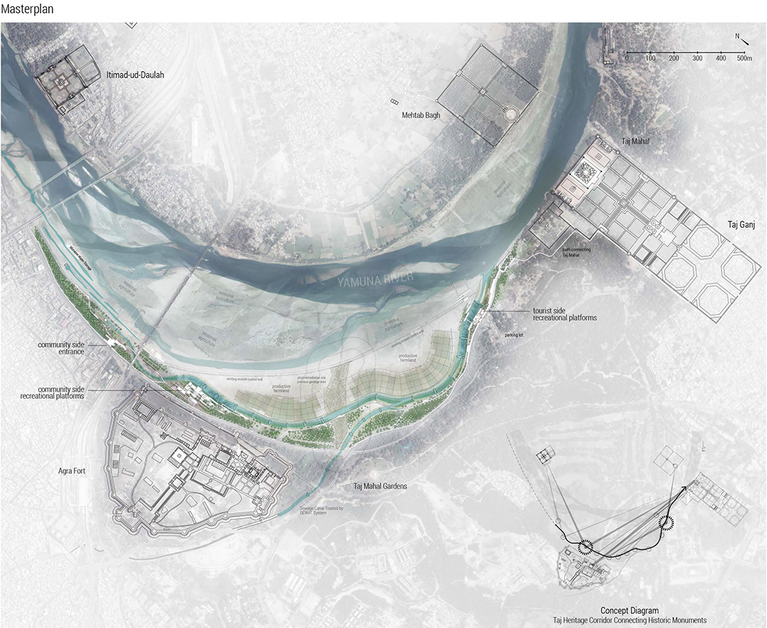
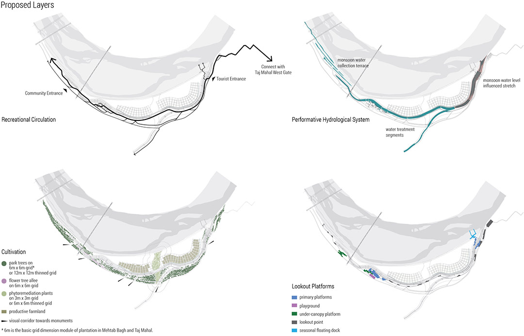
这个基于泰姬陵遗产廊道的方案,旨在重建阿格拉城堡周围河的意向,沿填埋工程之前的河道建立一条水处理运河。在景观设计的干预下,进而建议建设一系列城市基础设施,把历史建筑和城市公共空间联系起来,同时为当地居民和游客提供便利,亦对阿格拉境内亚穆纳河静谧的意向给予尊重。方案包含四个功能层:水系统、种植系统、休闲路径和瞭望平台。
The proposal on Taj Heritage Corridor Site aims to re-establish the image of river near Agra Fort by creating a water treatment canal along the original river bank before reclamation. Through landscape intervention, an urban infrastructure is proposed to connect the monuments and create public space for both tourists and local community, with a full respect of the silently mild image on Yamuna River in Agra. The design is composed of four performative layers: hydrological system, cultivation, recreational circulation, and lookout platforms.
水系统
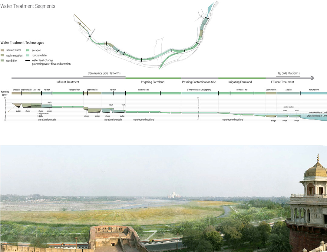
河水将被引入水处理河道,经过沉淀、曝气、过滤等处理步骤,以用来灌溉方案中的农田。灌溉用水在排放至亚穆纳河前被再次处理。沿城市的水岸地形将被重新整治,并配植被用以过滤城市径流。
Hydrological System
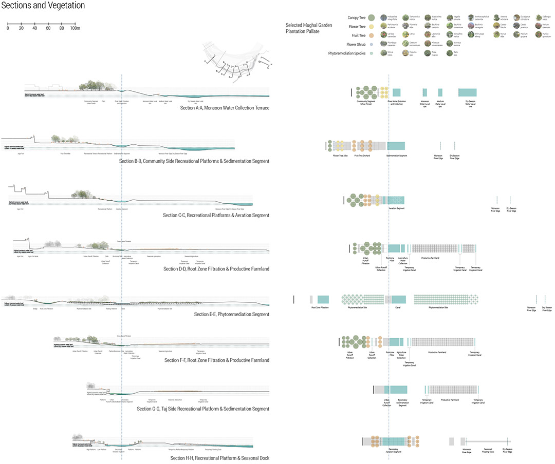
Water from river would be treated through segments of sedimentation, aeration, and root-zone filtration, and used for irrigating proposed productive farmland. The used water would be treated again before connecting with Yamuna River. The bank on urban side would be regraded and replanted to help filter urban runoff.
种植系统
种植系统基于莫卧儿时代花园的种植网格尺度。该网格与原有河岸垂直,而其中植物则从阿格拉现今受到保护的历史花园中选取适应城市环境的品种。乔木、灌木,包括主要活动空间附近的花树与果树,被用来增进根部过滤,以净化城市径流。在植被网格中留出连接泰姬陵等重要建筑的视觉廊道。现在场地上的垃圾应从河岸移至正规垃圾填埋场。污染区须被覆盖,以排污植被逐渐处理土壤污染,并在污染区外保留100米缓冲区。在水处理运河旁规划农业用地,以种植经济观赏作物,部分支持场地的维护。
Cultivation
A Mughal Garden scale grid that is perpendicular to the original river bank is used to manage proposed plants which are selected from planting palette currently used in protected monuments. Arbors and shrubs, including flowering trees and fruit trees near activity areas, are proposed to promote root-zone filtration for urban runoff. Visual corridors are left open towards Taj Mahal to promote the view. The garbage currently on site should be removed from river bank and be relocated in formal landfill. The polluted area must be capped and covered with phytoremediation species with a 100 meter buffer zone around it. Agricultural lands are located next to the proposed canal to produce ornamental plants that would financially support the maintenance of the project.
休闲路径
一个主要的步行道路沿运河展开,连接泰姬陵和阿格拉城堡北部的低收入居民区。小路穿过植被区,连接城市和新的水岸。
Recreational Circulation
A primary pedestrian path along the proposed canal connects Taj Mahal and the community area to the north of Agra Fort. Several smaller paths penetrate vegetated area to connect the new canal and the urban edge.
瞭望平台
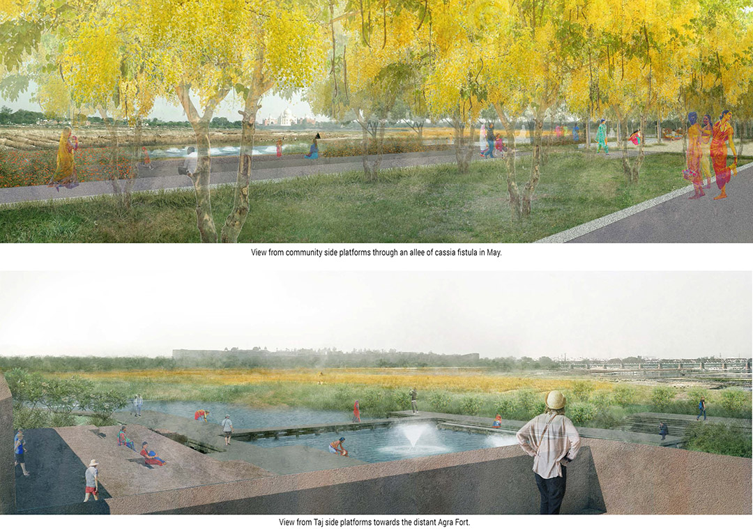
上游的居民区附近的水处理区段和下游的泰姬陵附近的水处理区段,提供了两个建立主要瞭望平台组合的有效场地:一个服务居民,另一个主要服务游客。这些主要平台,和河中央建议放置的季节性码头一起,积极地强调水岸活动、环保水处理技术以及从全新角度欣赏泰姬陵、阿格拉城堡、Mehtab Bagh花园、Itmad-ud-Daulah墓园之场地的共存状态。这些主要平台的建立有助于把场地重新定义为历史遗迹间的视觉联系。同时,在主要步道沿线设置规模较小的平台,点明水处理区段的功能变化。此场地有希望成为城市中心的主要公共空间,将当地人和旅游者引至同一场所,以此促进交流;同时作为教育空间,场地也强调了环境与历史的紧密内在联系。
Lookout Platforms
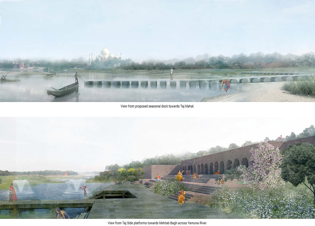
The upstream community side treatment and downstream Taj side treatment segments provide opportunities to propose two major complex of lookout platforms: one for the community, and the other one primarily for tourists. These major platforms, including a seasonal dock in the center of river, celebrate the coexistence of waterfront activity, water treatment technology, and the new perspectives to appreciate Taj Mahal, Agra Fort, Mehtab Bagh, and Itmad-ud-Daulah. The platforms would help reconsider the site as a visual connection of historic monuments. Smaller platforms are proposed along the primary path to highlight the shifting functions of water treatment segments. The site is expected to function as a central public space of the city that holds the locals and the tourists in the same space to encourage communication, while also serve as an educational space that highlights the inherent dialogue between environment and history.
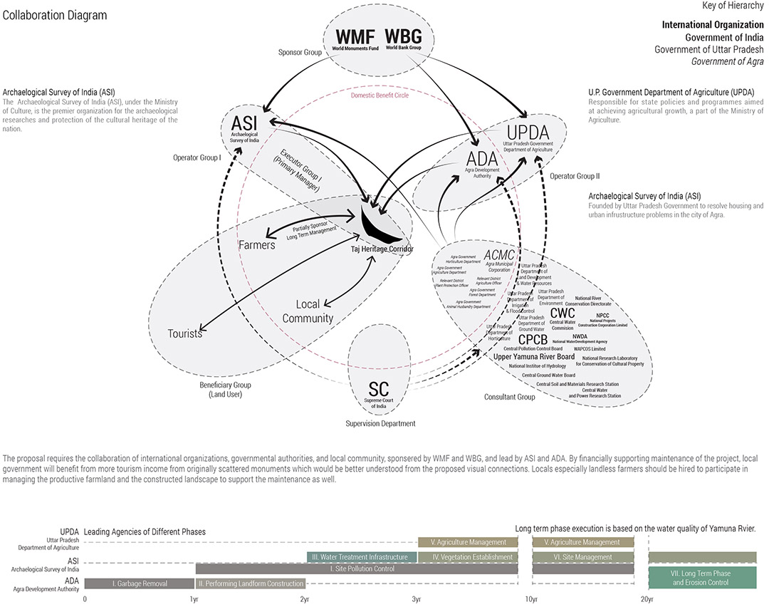
此方案的实施和管理将需要国际组织、政府机构和当地居民的友好协作。世界遗产基金会(WMF)和世界银行(WBG)是两个正在考虑泰姬陵遗产廊道方案可能性的国际组织,他们在阿格拉当地有丰富的赞助和合作经验,可成为工程的主要赞助者。该项目是当地重要的城市基础设施,其主要受益者是居民和游客,因而由与世界银行有合作经验的阿格拉城市开发组织(ADA,由北方邦直接管辖)来进行景观基础层的建设,包括移除场地垃圾,重整地形,建造水处理运河的基础部分。为了更好保护泰姬陵与阿格拉城堡间的视觉联系,作为印度政府保护其历史文物的主要力量,由世界遗产基金会自助的印度考古测量组织(ASI)将领导工程表层的建设,包括水处理系统、植被系统的建立以及长期的管理。对于该项目建设与维护的经济支持将使当地政府受益:由于历史遗迹联系的增强,许多以前少有拜访的景点将被纳入游览范围,旅游业也随之受益。当地人,尤其没有土地的穷人将被优先雇佣,并加入到农业用地和景观的管理中,这也将进一步支持场地的维护。
The proposal requires the collaboration of international organizations, governmental authorities, and local community. World Monument Fund (WMF) and World Bank Group (WBG) are both currently considering intervention options for Taj Corridor Site and could become sponsors of the project collaboratively. As an important urban infrastructure development that mostly benefits community and tourists, Agra Development Authority (ADA), with the experience of collaborating with WBG, should first prepare the base layer, focusing on garbage removal and landform construction of the proposed canal. And to better preserve the visual image between Taj Mahal and Agra Fort, Archaeological Survey of India (ASI) who is the major governmental force to protect historic monuments, now sponsored and collaborating with WMF, should lead to manage the surface layer which includes introducing water treatment infrastructure, vegetation establishment and long term management. By financially supporting maintenance of the project, local government will benefit from more tourism income from originally scattered monuments which would be better understood from the proposed visual connections. Locals especially landless farmers should be hired to participate in managing the productive farmland and the constructed landscape to support the maintenance as well.
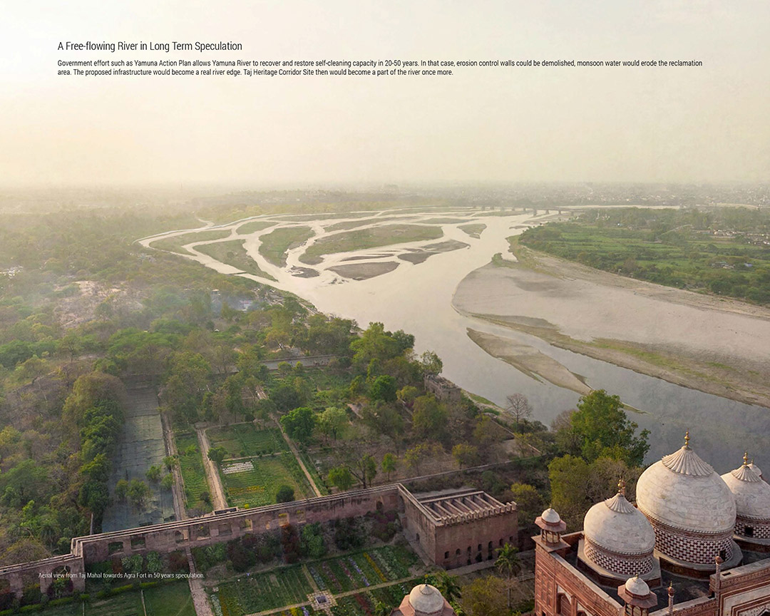
当今,一系列由印度政府资助的恢复环境的努力,如亚穆纳行动计划(YAP),给亚穆纳河在未来20-50年重获自净能力的目标带来了一线希望。这段时间内,一至两代人将伴随着阿格拉的这片净水景观长大成人。在亚穆纳河恢复一定自净能力时,此水处理系统维护河岸休闲空间水质的必要性将不复存在。届时,现存的防止河水侵蚀填埋区的河岸大堤将被拆除。雨季的洪水将年复一年不断冲刷填埋区,直至其再次成为亚穆纳河的一部分。
The current effort on government-sponsored projects such as Yamuna Action Plan (YAP) could be the hope for Yamuna River to restore its capacity of self-cleaning in 20 to 50 years. The time stretch allows one or two generations of people grow up with this water treatment landscape in Agra. At that time, this proposed treatment system will not be necessary for the recreational quality of river edge. The existing erosion control walls that are now protecting the reclamation site could then be demolished. Monsoon water would be allowed to erode the reclamation land, until the landfill area is totally removed and becomes a part of Yamuna River once more.
丘城
景观城市开发,牙买加湾,布鲁克林,纽约,纽约州,美国
合作:Ken Chongsuwat
指导教师:David Mah, Chris Reed
Orographic Hills
Landscape Urban Development, Jamaica bay, Brooklyn, New York, NY
Collaborator: Ken Chongsuwat
Instructors: David Mah, Chris Reed
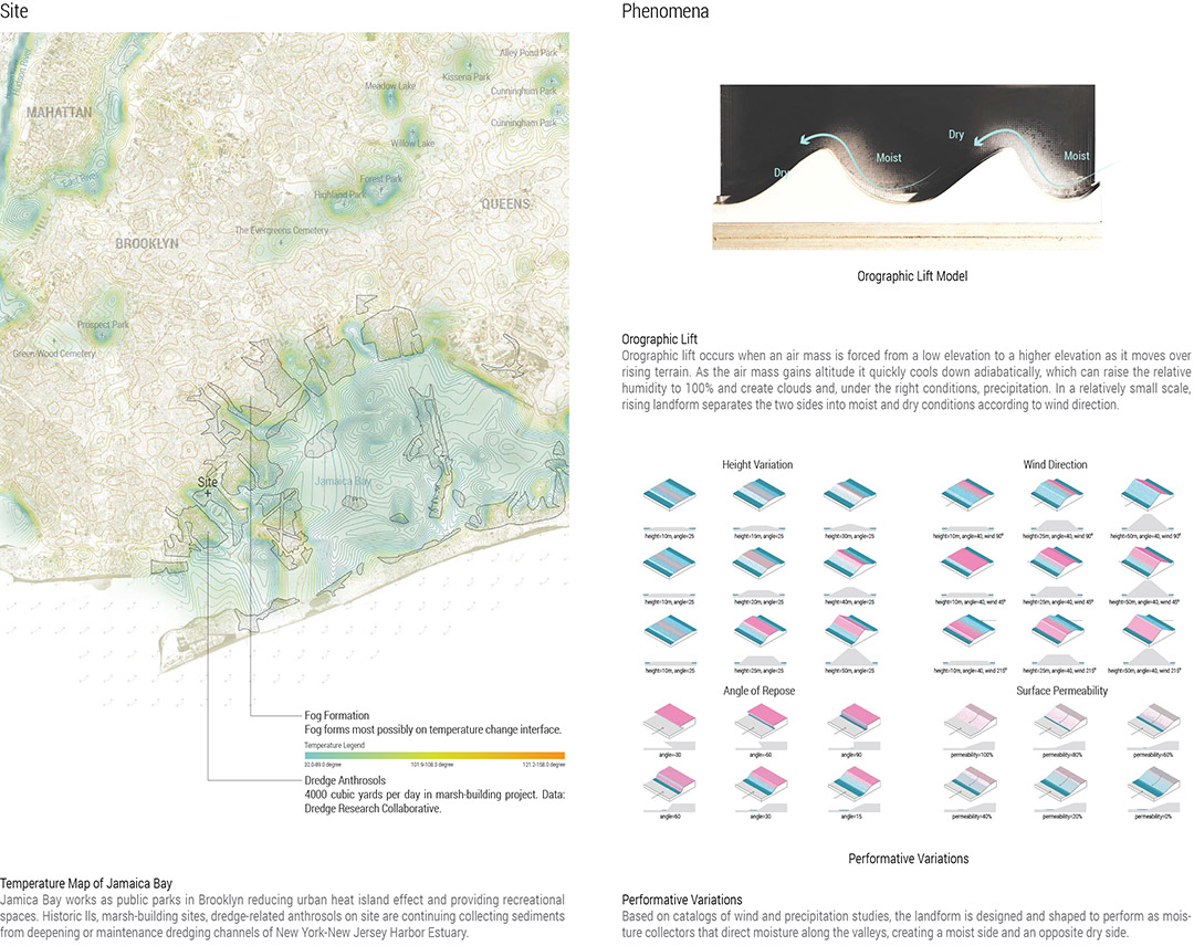
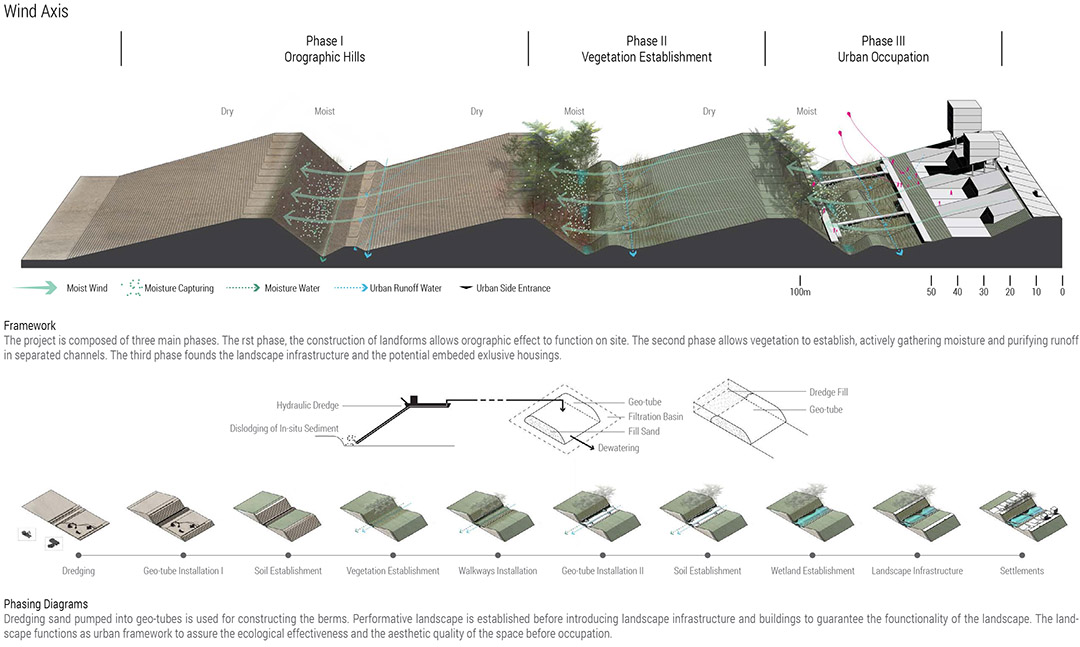
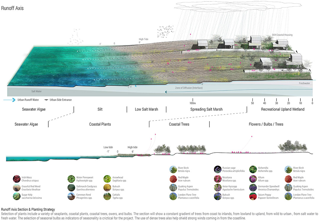
这片位于海边湾口的盐碱地拥有丰富而复杂的气候,其难点是设计一处适宜四季居住的环境。通过合理运用风向和降水的信息,场地在大尺度下对整个布鲁克林的气候有缓和作用,而在小尺度下课通过设计,强调微气候在场地内的作用。为达到这种效果,我们找到了一种通过风向角度定义的地形系统。通过对不同地形条件下风速和场地降水的研究,地形被设计成湿气的收集装置,并将湿气导入谷中;在地形上自然形成湿润坡和干燥坡。这种现象又被称为地形的抬升作用。
The site embodies a diverse and complex climate, the challenge was to design for suitable living conditions throughout the year within this complex site. Using studies on the wind direction and precipitation of the site, the project on a macro scale acts as a cooling mechanism for the region while on the micro scale the design promotes emerging micro climates within the site. To achieve this, a set of topographical moves are designed to form a field of angulated landforms that define the system. Using catalogs of wind and precipitation studies, the landform is designed and shaped to perform as moisture collectors that direct moisture along the valleys, creating a moist side and an opposite dry side. This effect is also known as orographic lifting.
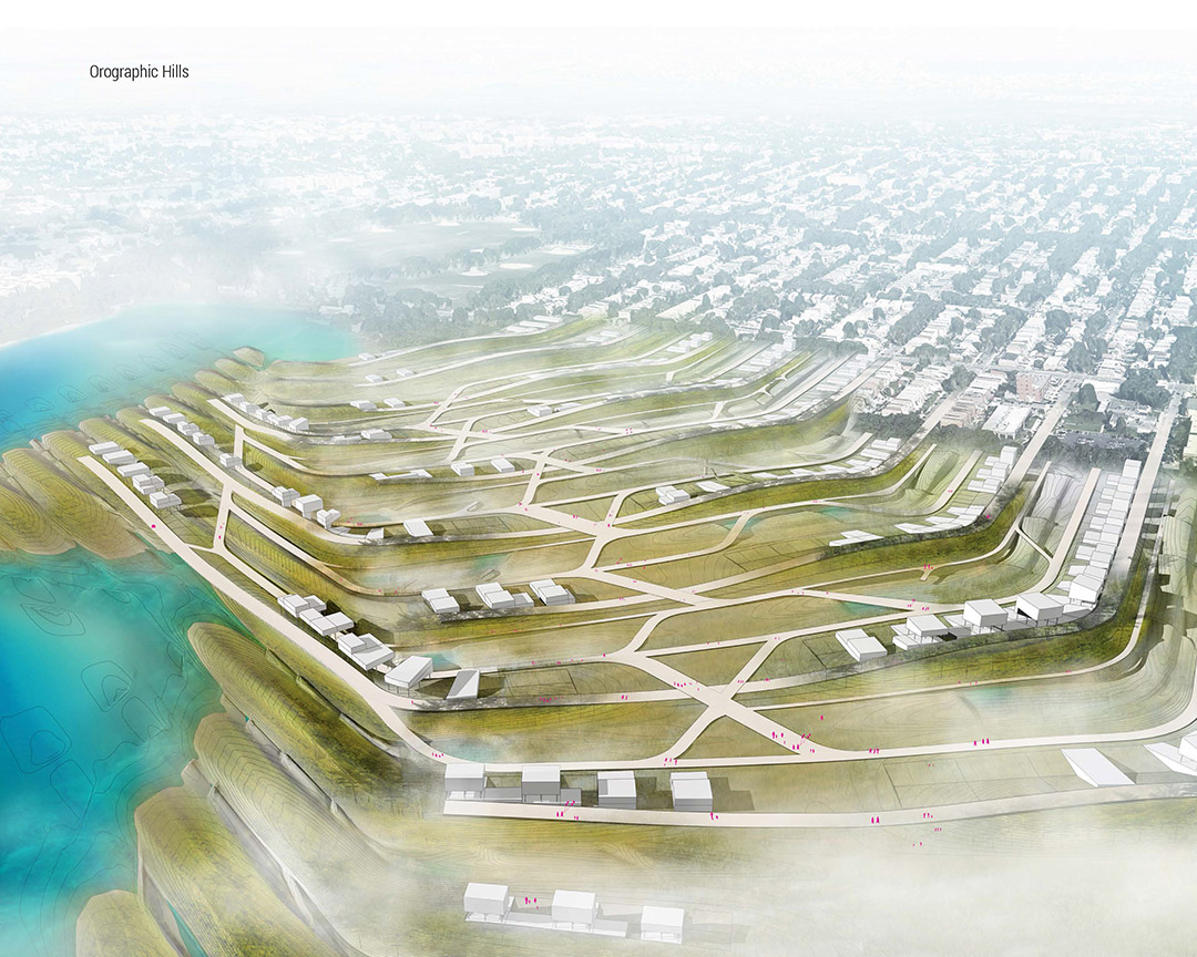
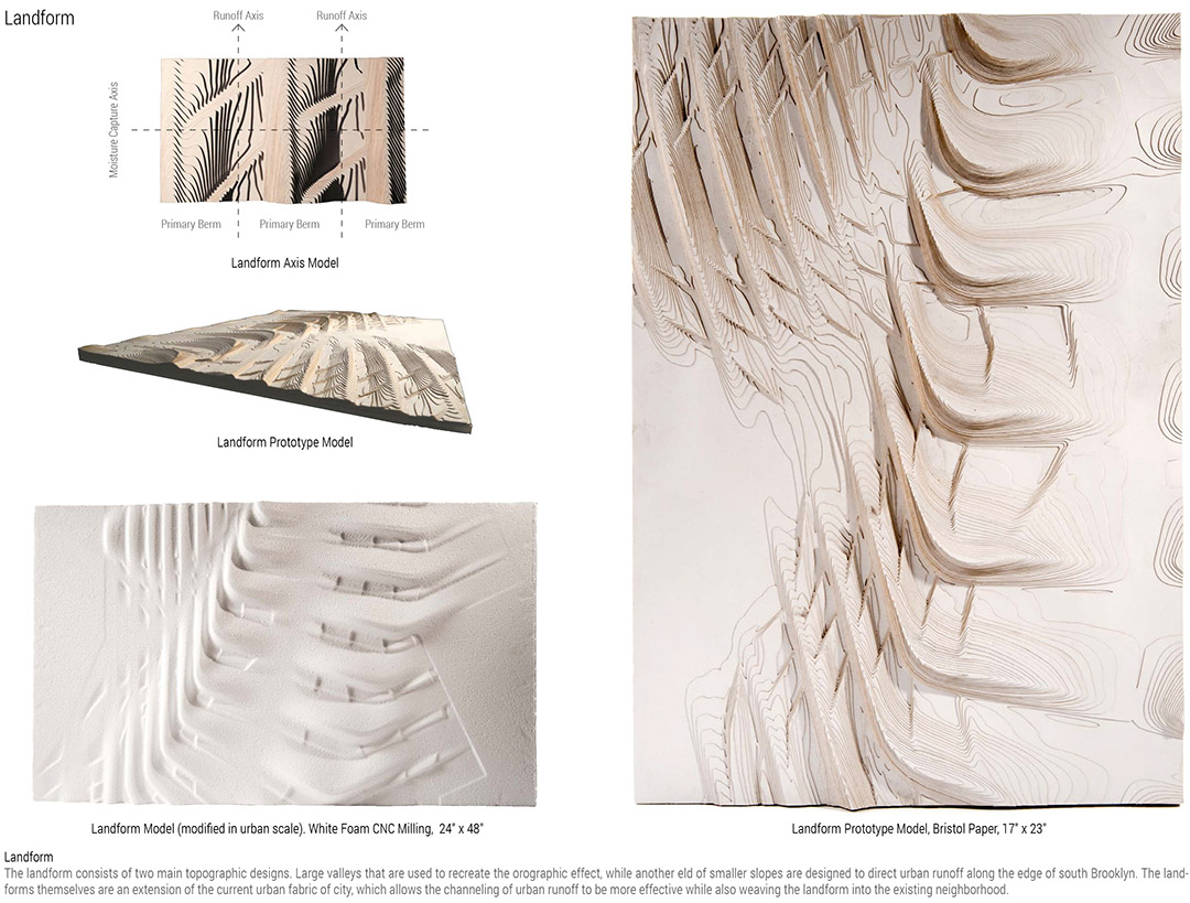
These landform consists of two main topographic designs. Large valleys that are used to recreate the orographic effect, while another field of smaller slopes are designed to direct urban runoff along the edge of south Brooklyn. The landforms themselves are an extension of the current urban fabric of the city, which allows the channeling of urban runoff to be more effective while also weaving the landform into the existing neighborhood.
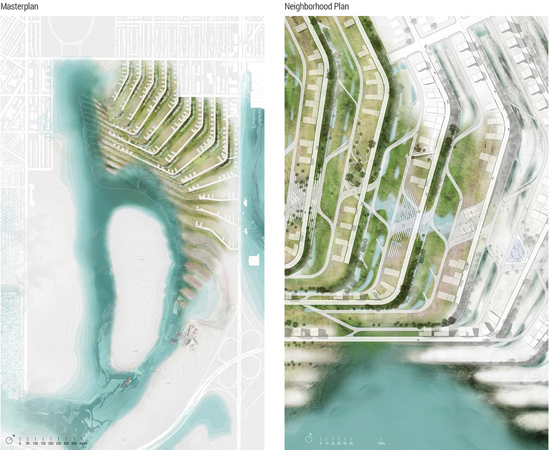
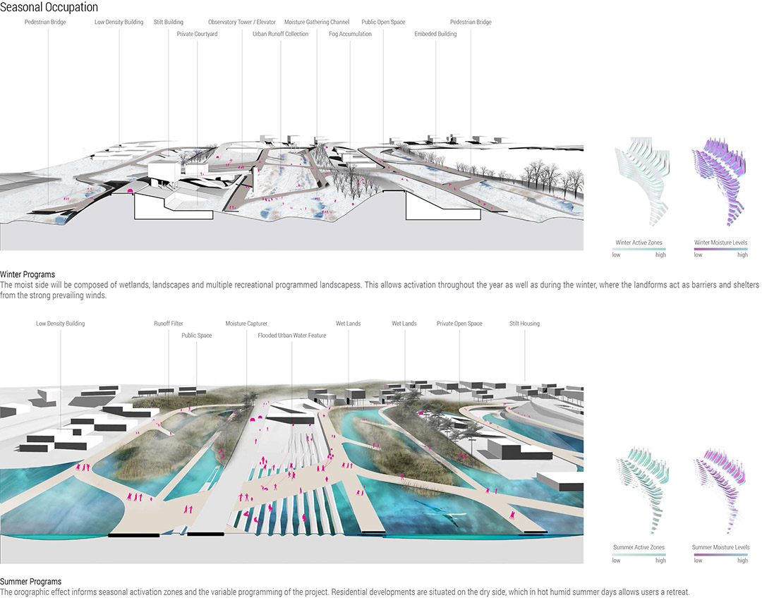
地形所产生的干湿分区使得场地在不同的季节产生不同的活性区域,以及随之适用的不同功能。私密的高等居住区被安排在山顶的干燥区,该区域在湿热的夏季给予人们一个舒缓场所。谷地的湿润区则被改造为公共的生态湿地以及休闲景观。地形在冬季保护谷地免受大风的侵扰,使得场地成为四季可用的空间。
The orographic effect informs seasonal activation zones and the variable programming of the project. Residential developments are situated on the dry side, which in hot humid summer days will allow users a retreat. The moist side will be composed of wetlands, and multiple recreational programmed landscapes. This allows activation throughout the year as well as during the winter, where the landforms act as barriers and shelters from the strong prevailing winds.
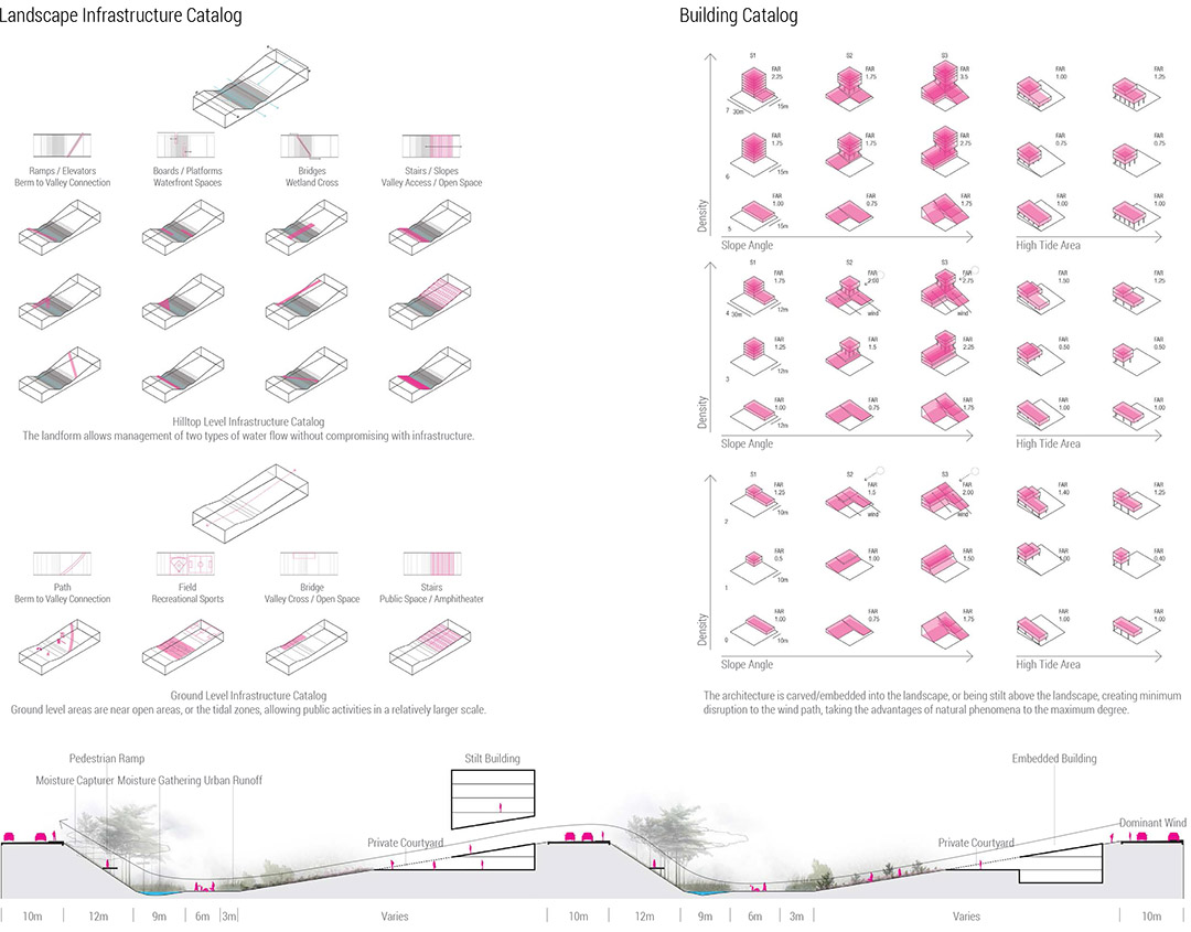
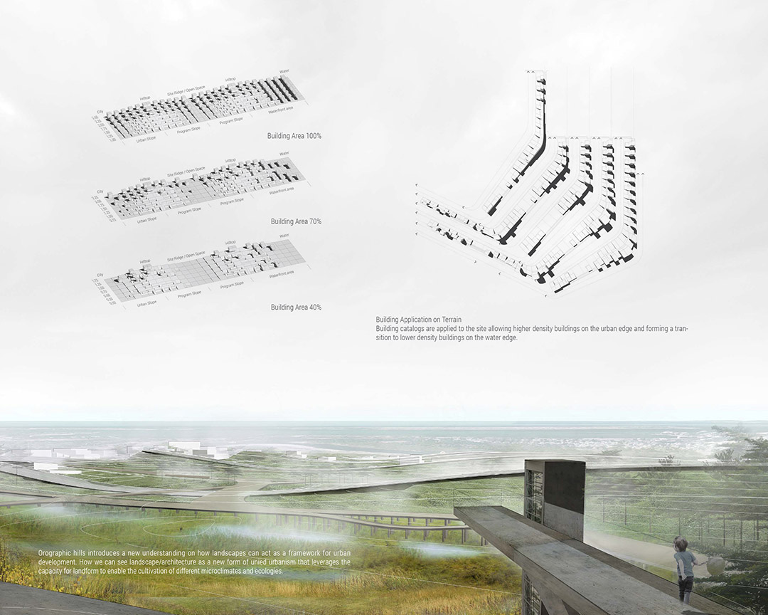
城市的开发被悄无声息地嵌入在景观地形中,建筑以顺应地形的方式和地形形成一个整体。这使风与湿气在场地上的阻力被降低到最小,使城市即是地景,地景即是城市。此方案期望把软景与硬景、自然与人造结合为一体。
Envisioning urban development that integrates seamlessly with the landscape, the architecture is carved and embedded into the landscape creating a unified landform. This allows less disruption to the wind paths as opposed to a typical high rise development as well as less additional infrastructure. The project embodies the concept of a hybrid between the softscape and hardscape, mixing and fusing materials that are soft and hard, natural and artificial.
此方案再现了一种把景观作为基础框架的城市开发方式,把地形、种植、微气候、生态环境和城市建筑作为整体考虑,从而提出一种可以全年使用的城市场所,同时创造私密、公共共存的多样生活环境。
Orographic hills introduces a new understanding on how landscapes can act as a framework for urban development. How we can see landscape/architecture as a new form of unified urbanism that leverages the capacity for landform to enable the cultivation of different microclimates and ecologies . Providing a city that can be programmatically activated 365 days a year within this new development while sustaining a dynamic living environment.
城市广场,剑桥,麻省,美国
指导教师:Gary Hilderbrand, Silvia Benedito
Fissure
Urban Plaza, Cambridge, MA
Instructors: Gary Hilderbrand, Silvia Benedito
城市中的三角洲可以被理解为两条道路交汇的某个端点;它也可以被理解为由三角洲为接缝而引领的大片城市区域。在剑桥市哈佛庭院周围的区域,有一些重要类似的三角空间,拥有端点或接缝的特质。它们因其环境与功能的不同而各异。
A Delta can be understood as a terminal of a larger scale confluence of two roads. It can also be understood as a joint between the area led by the delta and the space pointed by the angle of the delta. In the case of Cambridge around Harvard Yard, there are several deltas forming a network of landscape relationship with their features of terminals and joints. These deltas are distinguished from each other with different elements occupying and around the triangular space.
哈佛庭院是对城市相对封闭的空间,暗示着与城市的绝对不同。而哈佛庭院的边界使场地可以作为城市与庭院的接缝。这个小场地的城市区位决定了其东西向的走势,此走势也同时完善了哈佛庭院的几何上的缺角。
Harvard Yard is a relativey closed space to the city with a strict boundary suggesting absolute difference against the city. Yet the boundary of Harvard Yard provides opportunity for the site to become a joint as mentioned above. The spatial functionality of this delta may somehow determine the west-east directionality of the site. This directionality may seggest the leading and pointing direction of the delta as well as the sence of an uncompleted quadrangular of Harvard Yard.
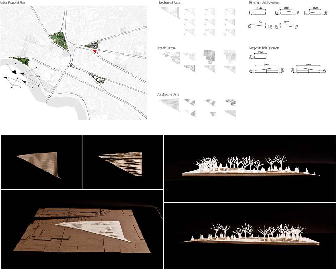
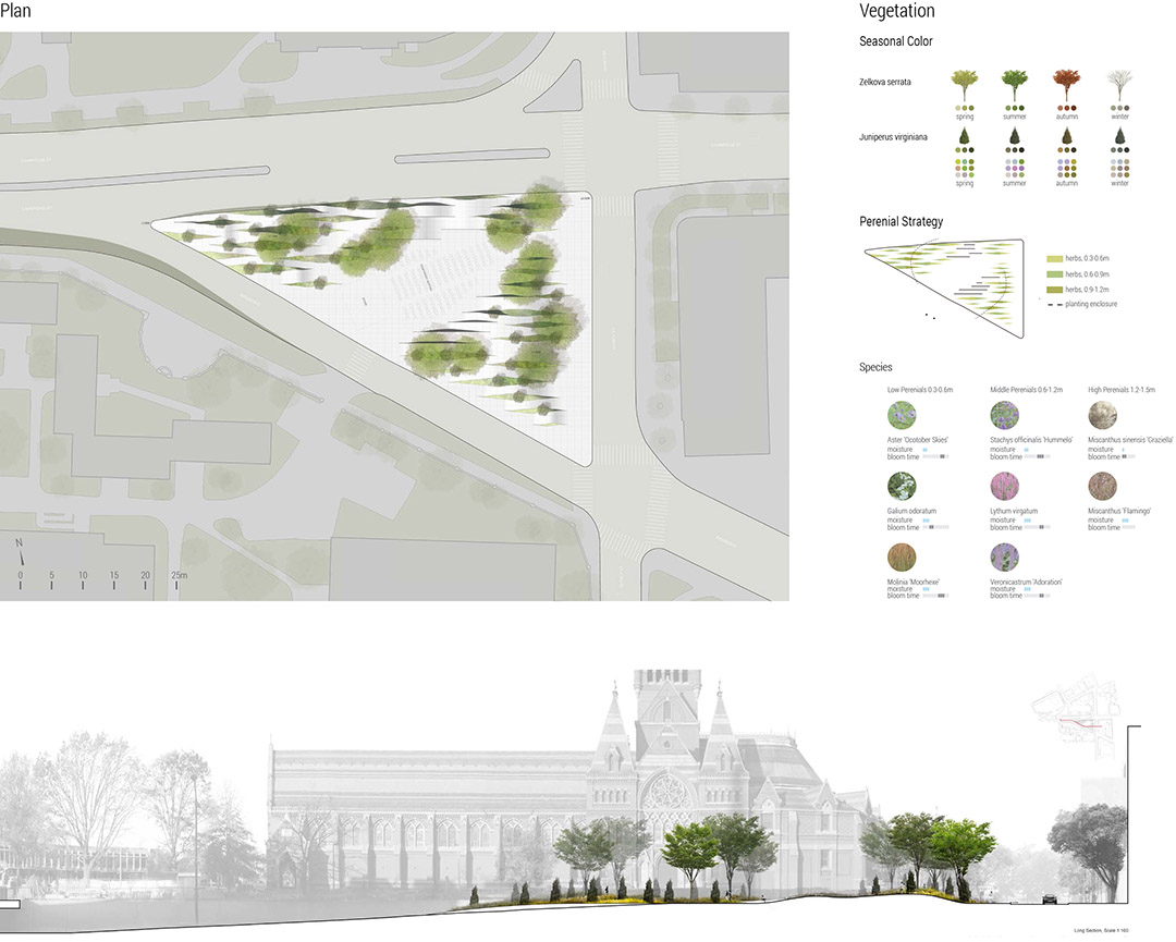
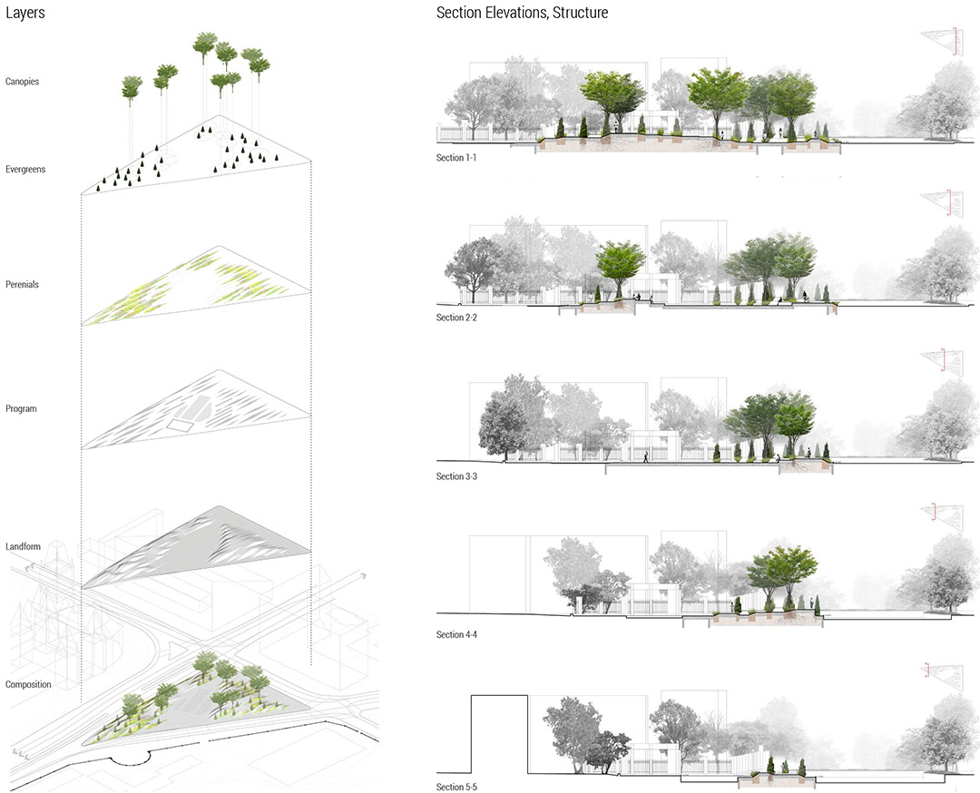
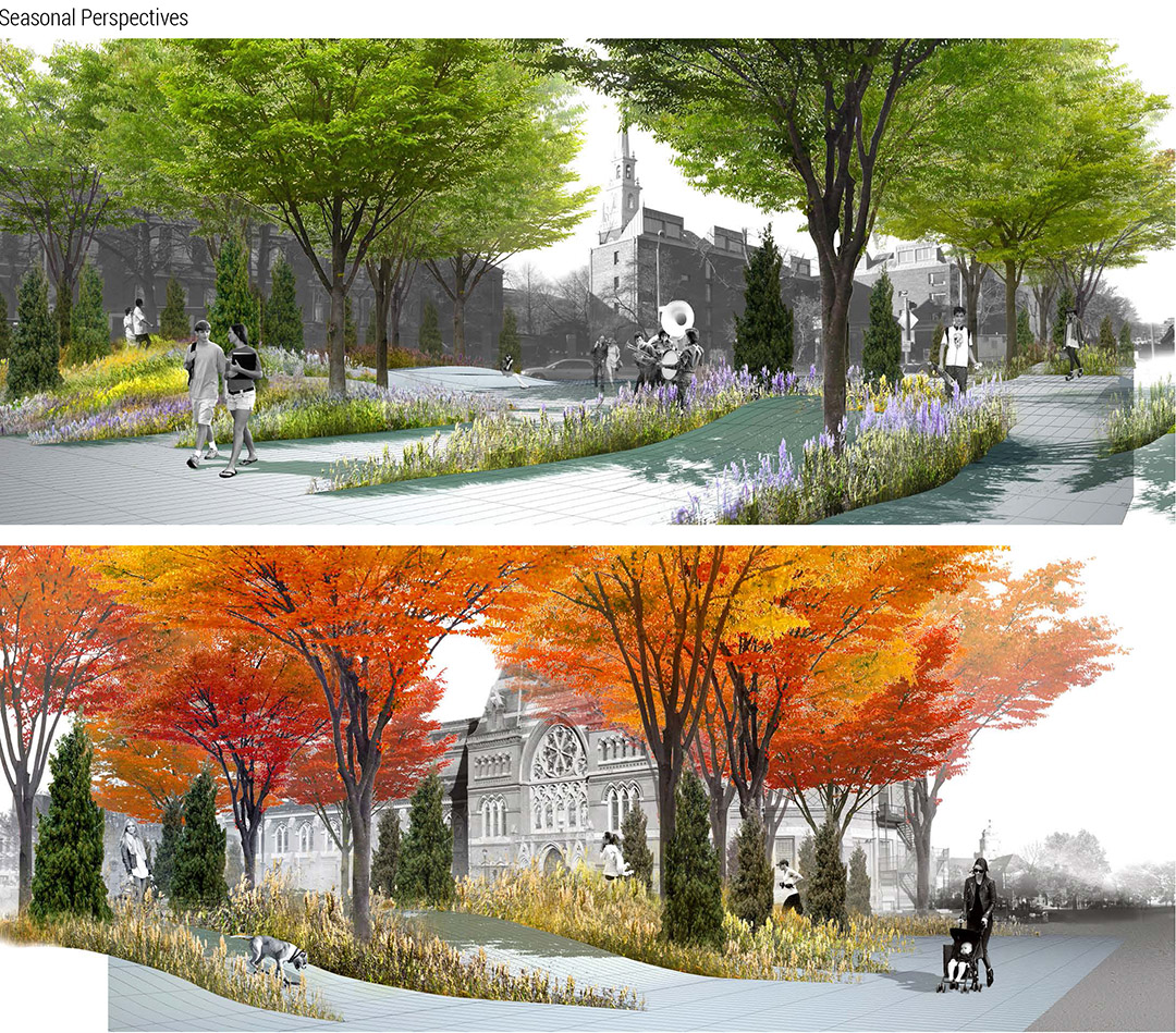
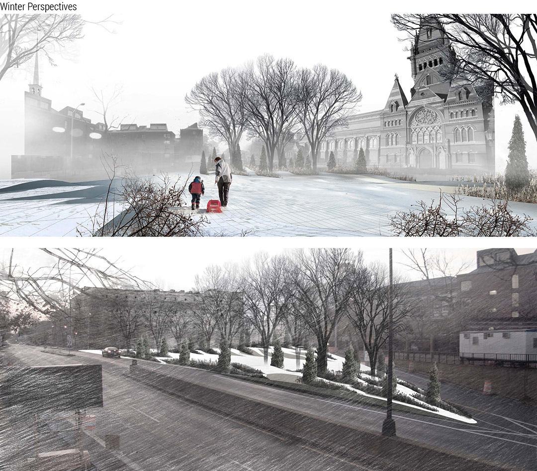
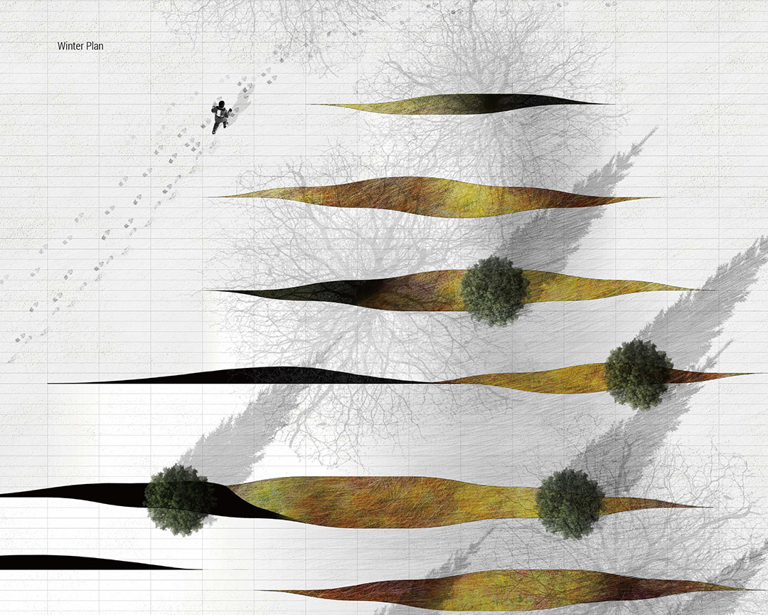
方案分为模块化铺装、起伏地形、种植三个部分。场地上的“缝”暗示了场地的方向性。地形的起伏将缝撕开,自然递退,形成阶梯和座椅,并将一个临时露天剧场区域围合在中心。地形和植被一起将周围的交通隔离在中心区域之外,植被层的分布暗示了哈佛纪念教堂、美术馆和设计学院的联系。这使得中心剧场成为穿行场地的必经之路,经过场地上课的学生成为场地活力不可缺少的元素。
The proposal is composed of unit pavement, waving landform, and planting proposal. The fissure on the landform determines the east-west linearity of the site, following the larger scale directionality of the delta. The landform tears the fissure apart, forming stairs and benches enclosing the proposed amphitheater. The landform is also blocking the traffic outside plaza center. The planting proposal implies another direction pointing towards the Harvard Memorial Church in the southwest, connecting the Art Museum and the Design School to Harvard Yard. This connection makes the amphitheater as the necessary way to pass for most users of the plaza. The crowd spontaneously form the central active zone of the site.
MORE:
When: 2012 – Current
Where: Boston
Who: Peichen Hao 郝培晨
From: Dalian, Liaoning
School / Office: Harvard University Graduate School of Design / Reed Hilderbrand LLC.
Contact: peichenhao@gmail.com
方案很棒
太牛了,特别是印度河畔改造,我去年11月才去了印度泰姬陵,真的污染很严重
Harvard
沙发~~赞师兄~~~
很清晰,逻辑很明确!
赞赞赞。
设计都非常好,但是印度人永远完成不了这么宏伟的设计的,在中国才有可能
a very cool design.