感谢 南沙原创建筑设计工作室 予gooood分享以下内容。更多关于他们,请至:NODE Architecture & Urbanism on gooood
Appreciation towards NODE Architecture & Urbanism for providing the following description:
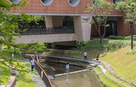
一条城市河流,在承担城市防灾等工程作用之外,还能承载什么?作为深圳唯一个有自然河道穿越的学校,深圳中学河道景观改造有了更多的期待:它不仅需要提升其行洪功能,在此基础上,还要将生态修复、公共活动与空间体验融入河道更新,使单纯的行洪河道、无法接近的水岸成为学校日常发生的一部分,成为连接自然与校园的开放滨水空间。
Beyond flood control, what else can an urban river offer? As the only school in Shenzhen with a natural river running through its campus, Shenzhen Middle School envisions a watercourse that goes beyond its engineering function. By integrating ecological restoration, public activities, and spatial experiences, the project transforms an inaccessible flood channel into an open waterfront, bringing nature closer to everyday campus life.
▼河道与校园公共空间,The watercourse and campus public spaces © 樊钊明 / Fan Zhaoming
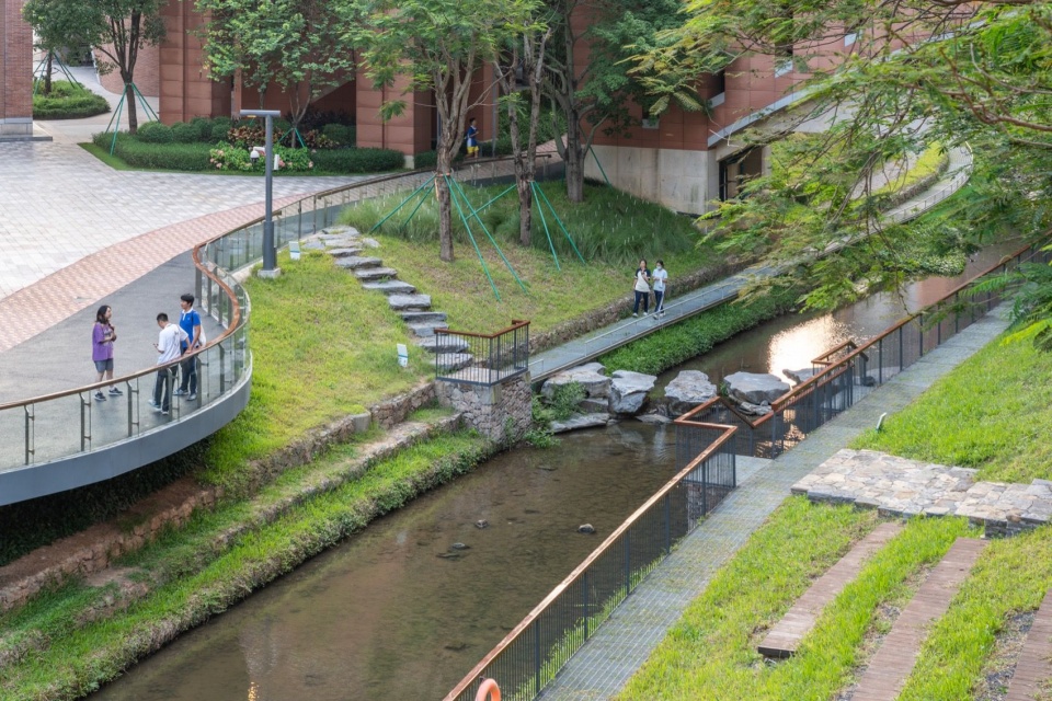
▼开放的校园水岸,An open campus waterfront © 樊钊明 / Fan Zhaoming
01 项目背景
Project Background
城市水系作为自然生态系统的重要基础网络,在早期高密度城市化建设的进程中,普遍经历了“裁弯取直、渠化硬化、加盖暗涵”等工程化改造,原本蜿蜒的自然河道逐渐被压缩为以排水为主的线性通道,甚至完全消失在城市地表之下,成为隐藏在钢筋混凝土丛林中的 “地下血脉”。笔架山河①正是这一演变过程的典型案例。河道发源于笔架山,全长约9公里,属于都市型河道②,流经泥岗村、八卦岭等居住与商业片区,流入布吉河后最终汇入深圳河,承担沿线流域的排水排污及金湖水库泄洪功能。城市扩张过程中,河道空间不断被侵占、压缩,部分河段被建筑覆盖,约5公里的城市建成区河道暗渠覆盖率超过90%,导致防洪排涝空间不足,生态调蓄、景观体验与人文价值随之减弱,暗涵结构也潜藏安全隐患。2020年,罗湖区启动“笔架山河道复明及沿线更新改造工程”,以提升水安全与水环境为核心,推进河道复明和生态碧道建设。
▼笔架山河流域图,
Bijia Shan River Basin Map © 改绘自深圳市水务规划设计院
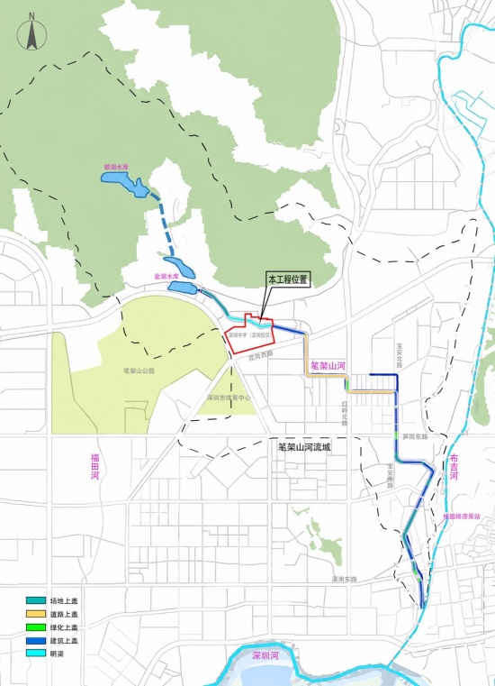
Urban waterways are vital components of natural ecosystems. During the rapid urbanization of densely built-up areas, many have been straightened, channelized, hardened, or covered over. Once meandering natural rivers have gradually been reduced to linear drainage channels, or disappeared entirely beneath the urban surface, becoming hidden lifelines within the concrete jungle. Bijia Shan River① is a typical example of this transformation. Originating from Bijia Mountain, the approximately 9-kilometer urban river② flows through residential and commercial districts, including Nigang Village and Bagualing, before joining the Buji River and eventually flowing into the Shenzhen River. It serves as a drainage and wastewater conveyance channel for the surrounding catchment and also discharges floodwater from Jinhu Reservoir. As urban development intensified, river corridors were progressively narrowed and buried beneath buildings. Along a five-kilometer stretch of built-up area, over 90% of the river channel was culverted, reducing flood capacity and diminishing its ecological, landscape, and cultural value, while posing potential structural safety risks. In 2020, Luohu District launched the Bijia Shan River Daylighting and Corridor Renewal Project, aiming to restore the river through improved flood resilience, ecological rehabilitation, and a continuous waterfront greenway.
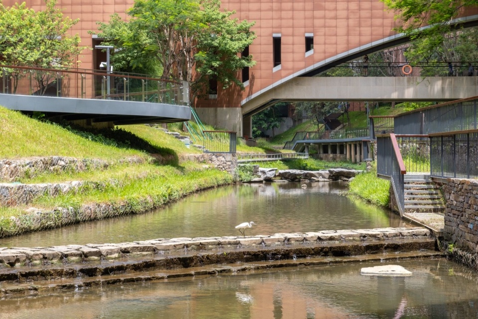
▼河道与廊桥,The watercourse and bridge © 樊钊明 / Fan Zhaoming
02 改造挑战与理念
Challenges and Design Concept
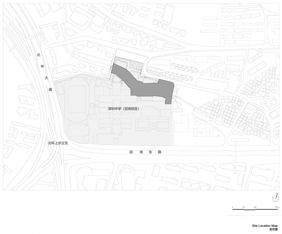
深圳中学(泥岗校区)边缘保留了一段约300米的笔架山河开放明渠,在笔架山河整体暗渠复明的背景下,设计以此为试验段展开改造,探索城市水利设施与校园公共空间共生的可能,并为城市暗渠复明与明渠更新提供实践参考。
At Shenzhen Middle School’s Nigang Campus, a 300-meter stretch of the Bijia Shan River remains open along the campus edge. Against the broader effort to daylight the river, the project uses this reach as a pilot to explore how urban water infrastructure can coexist with campus public space, offering practical insights for future river daylighting and open-channel renewal.
▼笔架山河道深中段位置,Location of the Shenzhen Middle School section of Bijia Shan River © NODE
▼河道现状视线,Existing Views of the Watercourse © NODE
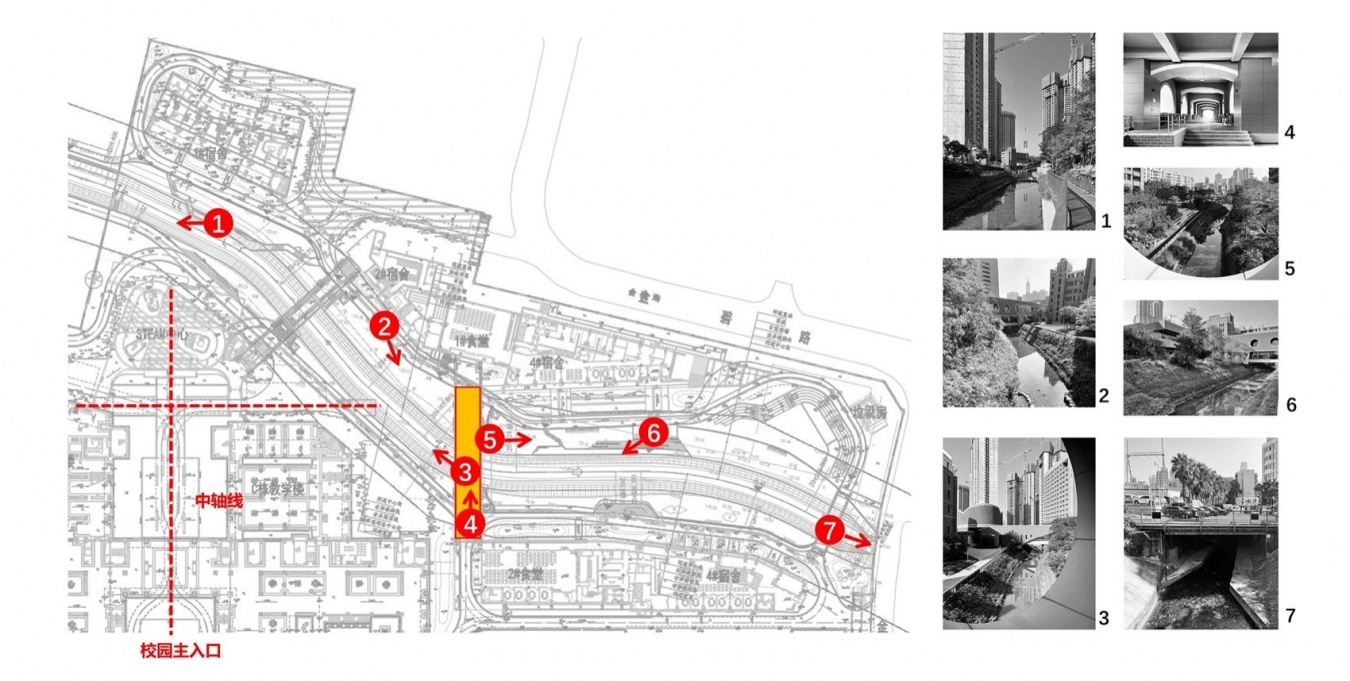
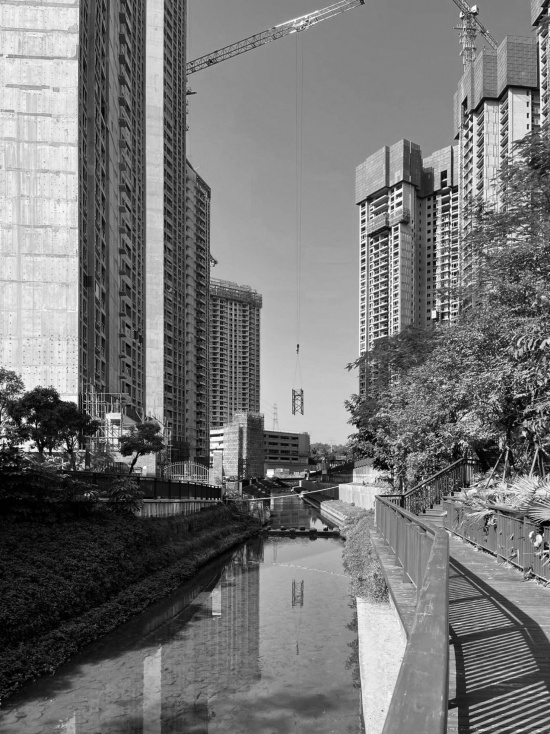
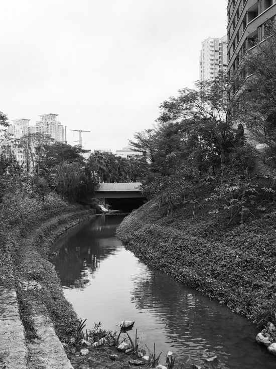
现存河道虽满足50年一遇的防洪标准,但生态基底和空间体验薄弱。“上斜下直”的复式梯形河道断面狭窄、竖向高差大,行洪能力有待提升;坡面缺乏雨水滞留措施,基流量小导致河床裸露;两侧石笼驳岸形式单一、局部结构外露,植被生长杂乱。连续的堤顶防护栏杆使河道空间趋于封闭,河道蓝线与滨水绿化带之间的空间未得到充分利用,缺乏连续的亲水路径与视线联系。
Although the existing watercourse meets the 1-in-50-year flood protection standard, its ecological quality and spatial experience remain limited. The narrow compound trapezoidal section, with sloping upper banks and vertical lower walls, creates significant level differences and leaves room for improved flood conveyance. The slopes lack rainwater retention measures, while low baseflow leaves parts of the riverbed exposed. Along both banks, the repetitive gabion revetments, exposed structural elements, and unmanaged vegetation further weaken the landscape. Continuous embankment railings isolate the river from the campus, while the space between the river corridor and the adjacent green belt remains underused, lacking continuous waterside paths and visual connections.
▼改造前不同位置河道现状,Existing Watercourse Conditions
at Various Locations Before Renovation © NODE
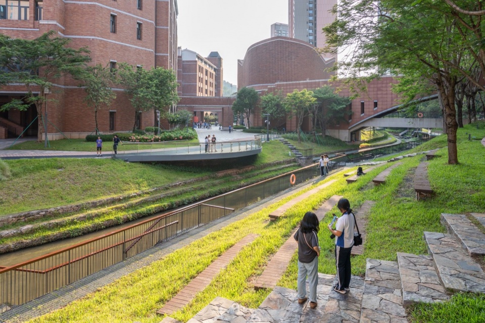
作为深圳市唯一一所校园内有行洪河道穿过的学校,深圳中学的河道改造面临双重课题:如何在保障行洪安全的前提下,将城市水利设施转化为校园内独特、有灵气的水风景,彰显生态示范校园的特色。设计以提升行洪能力为前提,探索“明渠活化”③,将雨洪安全、生态景观与校园亲水活动相结合,打破单一的工程边界,使水岸成为师生可亲近、可感知、可参与的开放空间。剑桥康河(River Cam)、牛津查韦尔河(River Cherwell)及泰晤士河牛津段(当地称埃西斯河,The Isis)等水系,在与校园环境的长期共生中,形成了漫步、阅读、交流与泛舟交织的滨水日常。受这些亲水场景启发,深中的设计立足既有水利条件,以轻介入的方式重新组织河道、绿地与校园活动的关系,将书香气息融入水岸空间,在高密度城市校园中留存一份原生而鲜活的野趣。
As the only school in Shenzhen with a flood-control watercourse running through its campus, Shenzhen Middle School faced a dual challenge: ensuring flood safety while transforming urban water infrastructure into a distinctive, vibrant waterscape that reflects the character of an ecological demonstration campus. The design prioritizes flood conveyance capacity while exploring the revitalization of open watercourses③, integrating flood safety, ecological landscaping, and campus waterfront activities. It moves beyond the conventional boundaries of water infrastructure, transforming the riverbank into an open space where students and teachers can access, experience, and engage with the water. Through long-standing coexistence with their campuses, waterways such as the River Cam in Cambridge, the River Cherwell in Oxford, and the River Thames in Oxford, locally known as the Isis, have fostered a waterfront culture of walking, reading, socializing, and boating. Inspired by these waterfront experiences, the design works with existing water infrastructure and uses light-touch interventions to reconnect the watercourse, green spaces, and campus activities. It brings a scholarly atmosphere to the waterfront while preserving a sense of natural vitality within the dense urban campus.
▼深中河涌,Bijia Shan River at Shenzhen Middle School © 樊钊明 / Fan Zhaoming
03 改造策略
Renovation Strategies
设计基于现状河道形态,充分考虑防洪与生态结合、河道与学校活动融合、生物多样性营造等,工程上以防洪安全为基础,空间上以景观营造为呈现,实现水利功能与校园环境的有机结合。
The design builds on the existing watercourse, integrating flood protection, ecology, campus activities, and biodiversity. Flood safety guides the engineering, while landscape design shapes the space, bringing water infrastructure and the campus environment together.
▼深中河涌,Bijia Shan River at Shenzhen Middle School © 樊钊明
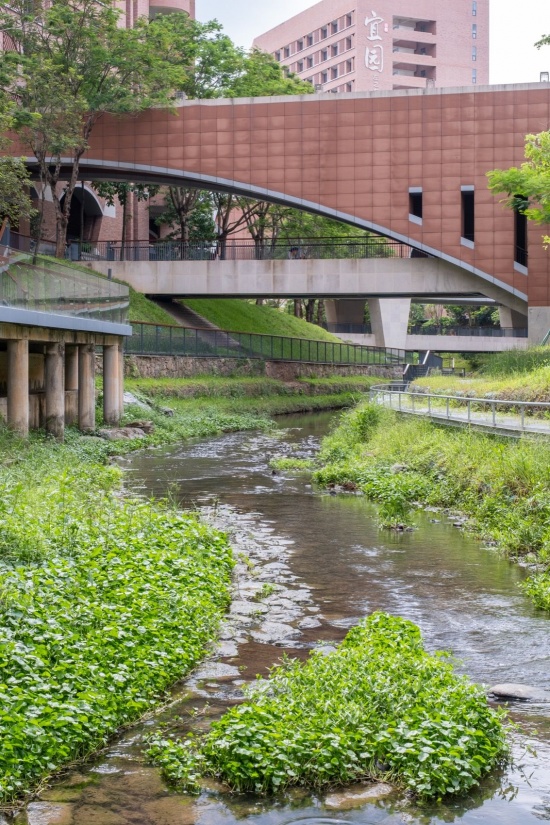
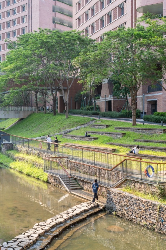
.
水系统重构 | 进一步提升河道防洪韧性与生态水景价值
Water System Reconfiguration | Enhancing Flood Resilience and Ecological Value
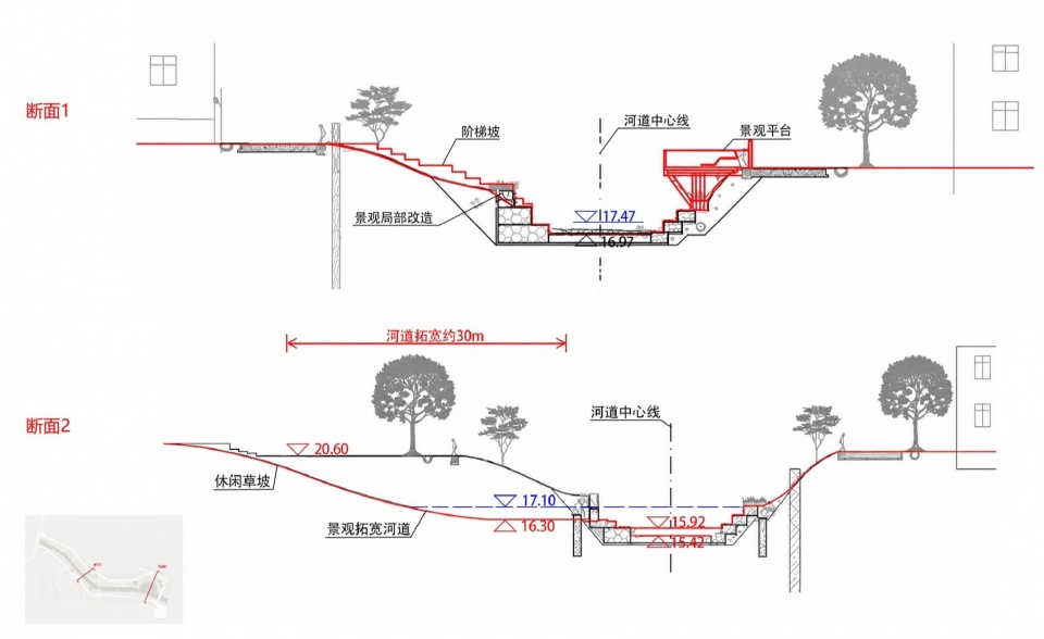
重点对两处河段进行断面优化:一处将驳岸改造为阶梯坡,改善陆域与水域之间的生态过渡;另一处局部拓宽下游河道,扩大过水断面,结合水闸调控水位、壅水扩容形成稳定水面,增加蓄滞空间。同时,根据水闸运行要求局部抬高闸前河床,控制水深,为泛舟、船艇等亲水活动创造条件。此外,设计延续海绵城市理念,通过植被缓冲带、透水路面、下沉式绿地及生物滞留种植槽设施,构建雨洪调蓄与生态净化体系;增补地被、草坪及滨河植物,强化驳岸保护与生态修复,提升河道生态韧性,并利用内循环泵与滤料池维持水体循环与水质稳定。
Two sections of the watercourse are optimized to improve flood resilience and ecological value. One embankment is reshaped into stepped slopes to create a gradual ecological transition between land and water. The downstream channel is locally widened to increase flow capacity and storage. Sluice gates regulate water levels, creating a stable water surface and additional storage capacity. The riverbed is also raised locally upstream of the gates to control water depth and accommodate boating and other waterfront activities. The design applies sponge city principles through vegetated buffers, permeable paving, sunken green spaces, and bioretention planters to manage stormwater and filter runoff. Additional groundcover, lawns, and riverside planting strengthen bank protection and ecological resilience. A circulation pump and filter bed help maintain water circulation and quality.
▼局部河道横断面改造情况,Local Watercourse Section Modifications © NODE
.
空间重构 | 形成体验丰富的校园水廊道
Spatial Reconfiguration | Creating a Richly Experiential Campus Waterfront
设计以点、线、面三种空间策略介入,重新整合两岸空间。
The design uses three spatial strategies—points, lines, and surfaces—to reorganize spaces along both banks of the watercourse.
▼总平面图,Site Plan © NODE
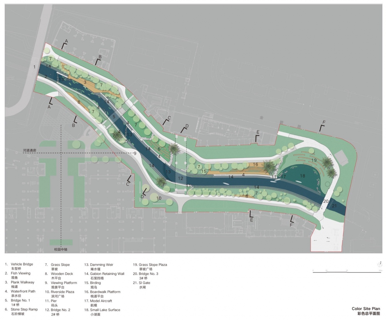
点—放大空间:沿河道展开的线性连续路径被局部打开,形成多个尺度不同的停留节点。观景平台、石阶梯坡、草坡广场等开放节点,可承载户外课堂、小组讨论、毕业合照等校园活动。其中,利用线性河道通廊与校园中轴的空间关系,设计在河道中游融入整个校园书香气质,形成具有聚集性的校园“人文中心”。
Points—— Expanded Spaces: The continuous path along the watercourse opens up at key points to form gathering spaces of different scales. Viewing platforms, stepped banks, and grassy plazas accommodate outdoor classes, group discussions, and graduation photos. In the middle section, the design draws on the relationship between the watercourse and the campus’s central axis to create a humanistic hub that reflects the campus’s scholarly character.
▼设计策略,Design Strategies © NODE
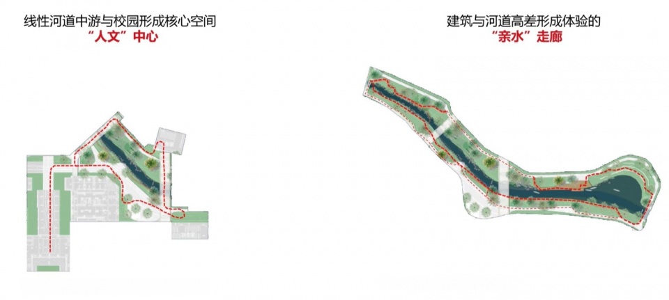
线—嵌入路径:设计多层级步道组织于河道上部的生态缓坡。结合堤顶道路与驳岸改造,将校园步行系统自然延伸至水岸,串联不同标高的停留平台与观景节点,形成层次丰富的水廊道。人的行走路径逐渐靠近水岸,视线、树影与水流不断交织。
Paths—Integrated Circulation: Multilevel paths follow the ecological slopes along the upper banks of the watercourse. Through embankment road and bank improvements, campus walkways extend naturally to the waterfront, connecting platforms and viewing points at different levels. As people walk closer to the water, views, tree shadows, and flowing water intertwine.
▼改造后河道融入校园之中,The Watercourse Reintegrated into the Campus After Renovation © 樊钊明 / Fan Zhaoming
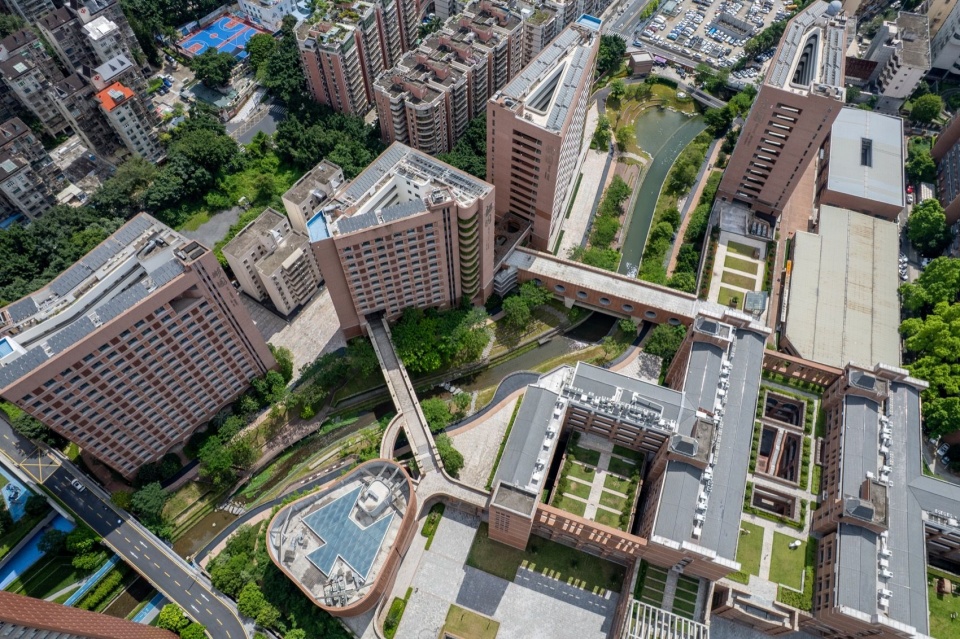
面—延展界面:以河道为纽带,串联两岸既有分散的绿地、岸线与校园开放空间形成滨水场域,草坡、台阶、平台等顺势展开,将原本明确的河岸边界逐渐消融为开放的公共界面,校园生活也由此自然向水岸延伸。
Surface—Extended Interface: The watercourse connects existing green spaces, riverbanks, and campus open spaces on both sides to form a continuous waterfront. Grassy slopes, steps, and platforms extend along the terrain, softening the riverbank boundary into an open public interface and allowing campus life to flow naturally toward the water.
▼改造后河道融入校园之中,The Watercourse Reintegrated into the Campus After Renovation © 樊钊明 / Fan Zhaoming
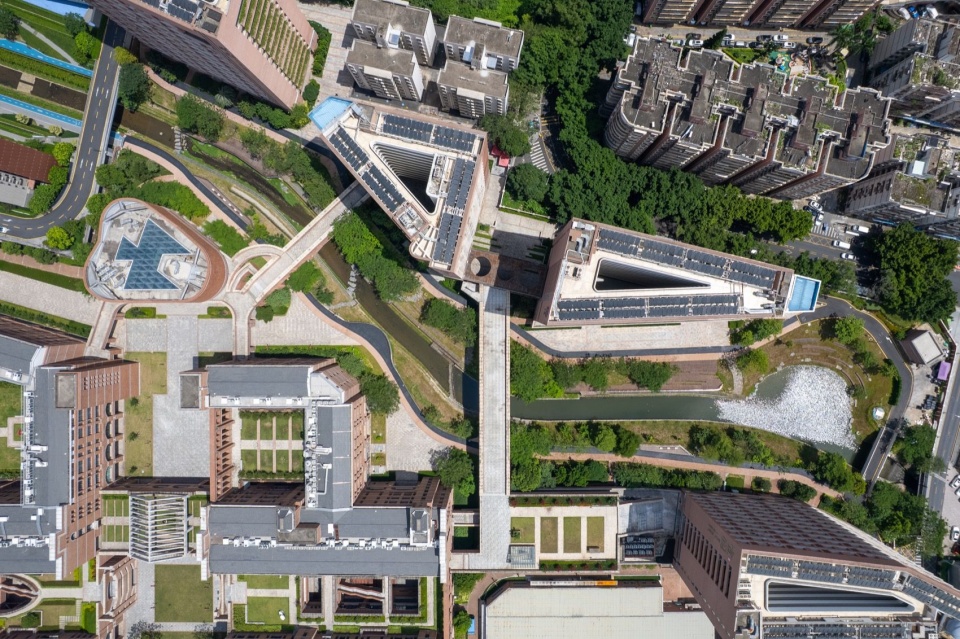
04 多层步行系统
Multilevel Pedestrian System
设计顺应既有河道的线性行洪路径,在有限的岸线条件中植入一套上下交织的多层步行系统,枯水期时,多级节点消除地面到水面的高差,丰水期时,满足安全要求。堤顶主路径延续校园原有交通网络,承担日常及行洪期间通行功能,成为连接不同校园空间的主要动线。
The design follows the watercourse’s linear floodway, introducing an interconnected, multilevel pedestrian system along the limited banks. In dry periods, stepped platforms bridge the level difference between land and water; during high water, they meet safety requirements. The main path along the embankment extends the campus circulation network, providing a key route between campus spaces in daily use and during flood events.
▼多层步行系统,Multilevel Pedestrian System © NODE
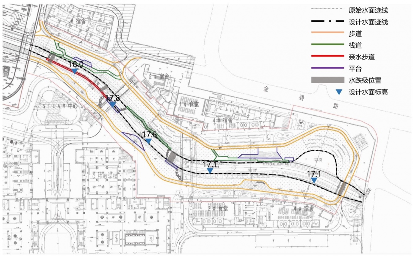
沿着岸线缓缓展开的竹木栈道和低位亲水步道,则将人的视线与身体逐渐引向水面。非行洪时期,师生可以沿亲水步道漫步至河岸边缘,在此停留,感受水流、植被与季节变化带来的细微感受,天气好的话,或许还能与停驻浅滩的白鹭不期而遇。
Bamboo-and-timber boardwalks and low-level waterside paths follow the riverbank, bringing people closer to the water. In dry periods, students and teachers can stroll to the water’s edge, pause, and experience subtle changes in the water, vegetation, and seasons. On fine days, egrets may even appear on the shallows.
▼栈道与亲水步道,Boardwalk and Waterside Path © 樊钊明 / Fan Zhaoming
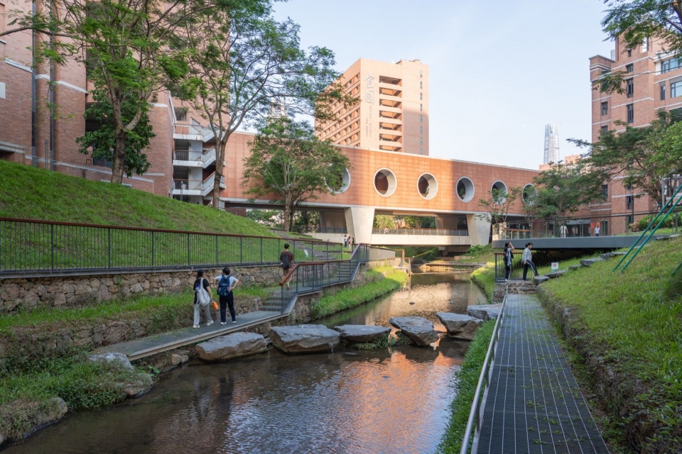
▼栈道与亲水步道,Boardwalk and Waterside Path © 樊钊明
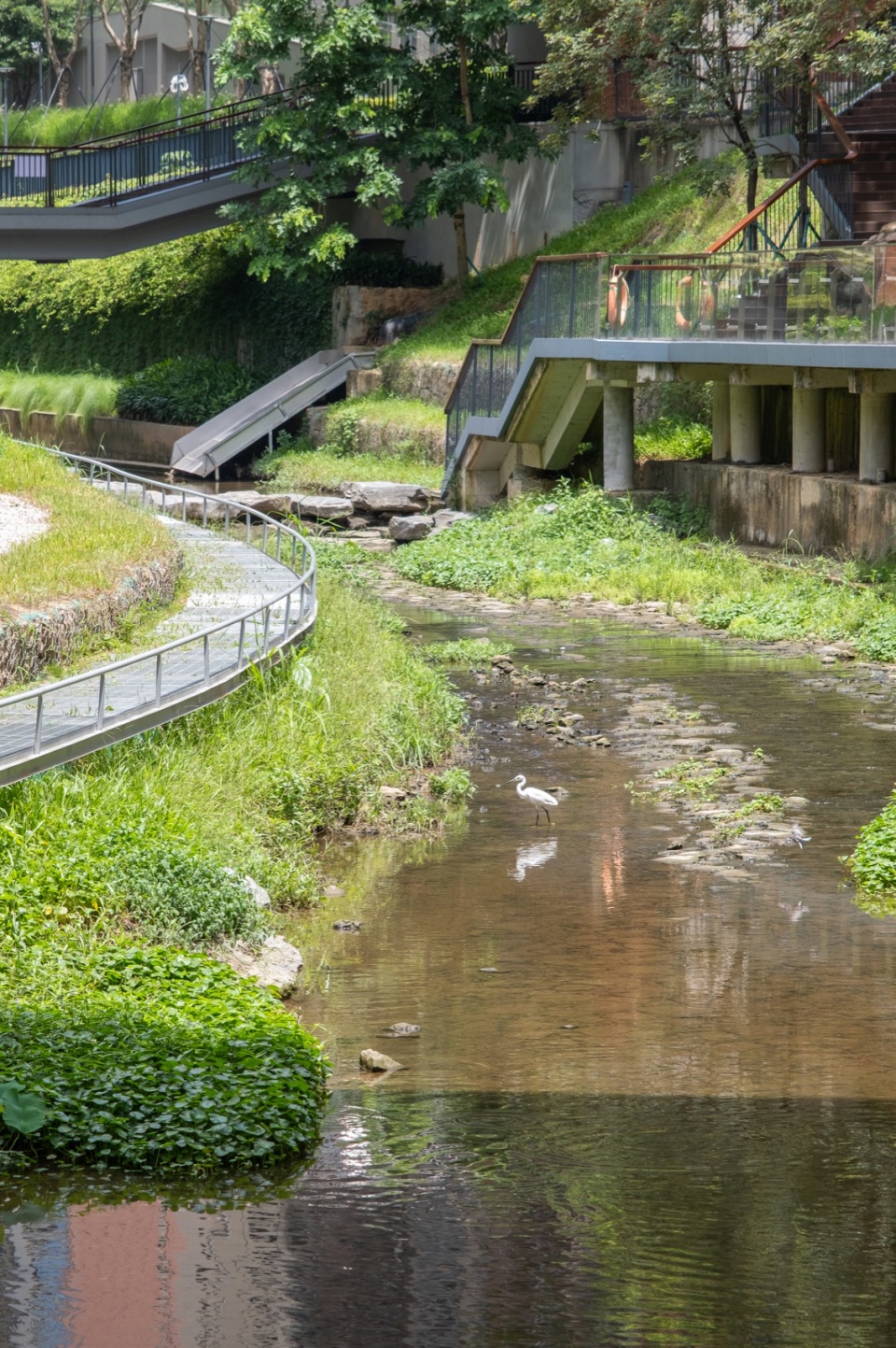
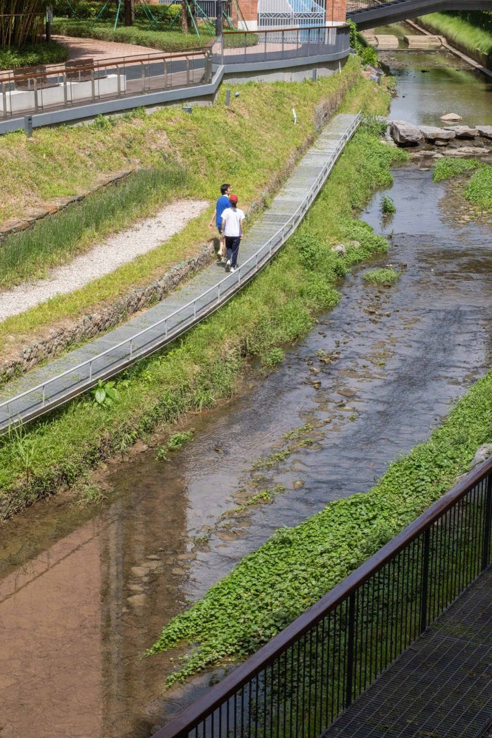
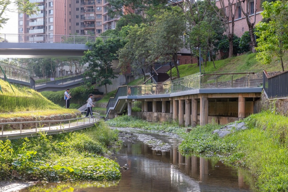
高差原本作为河道安全运行的限制条件,成为空间序列组织的契机。设计通过水平路径与竖向空间的共同组织,将不同标高的步道、节点与水体建立连贯联系,形成多层交叠的空间系统。人在行走过程中,感受由观景到亲水的不同变化。
The level differences, once a constraint on watercourse safety, become an opportunity to shape the spatial sequence. Horizontal paths and vertical connections link walkways, gathering points, and water at different levels, creating a layered spatial system that shifts the experience from viewing the water to engaging with it.
▼栈道与亲水步道,Boardwalk and Waterside Path © 樊钊明 / Fan Zhaoming
05 分段更新:塑造多元滨水场景
Phased Renewal: Creating Diverse Waterfront Experiences
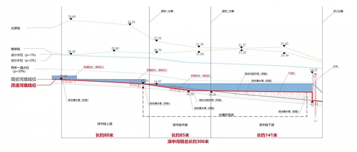
高差、水流与岸线生态条件的不同,300m的明渠河道也呈现出差异化的空间性格,设计据此将其划分为上游自然段、中游人文段和下游开放段。上游延续河岸自然生长状态,营造可观察、可感知的原生环境;中游呼应校园中轴,形成人文景观节点;下游结合水闸设施设置科普展示,并向开放式活动空间延伸。三段各具特色,又通过连续的水岸空间彼此衔接。
Differences in elevation, water flow, and riverside ecology give the 300-meter open watercourse three distinct characters: an upper natural section, a middle cultural section, and a lower open section. The upper section preserves a natural riverside environment for observation and exploration; the middle forms a cultural landscape node aligned with the campus axis; and the lower integrates water-gate facilities with educational displays and open activity spaces. Each section has its own character, linked by a continuous waterfront.
▼改造后河道纵剖面图,Watercourse Section After Renovation © NODE
上游自然段 | 生态基底与轻介入更新
Upper Natural Section | Ecological Foundations and Light-Touch Renewal
上游河段地势平缓,水流舒缓,岸线长期保持着较为完整的自然生长状态,成为鱼类、水鸟与水生植物共生的主要生态区域。设计以生态保育为原则,尽量减少对原有地形与植被的扰动,轻介入地延续河道原有松弛秩序。
The upper section has gentle terrain and slow-moving water, with largely intact natural banks that support fish, waterbirds, and aquatic plants. Guided by ecological conservation, the design minimizes disturbance to existing landforms and vegetation, preserving the watercourse’s natural character through light-touch interventions.
▼上游自然段改造前后,Upper natural section before and after renovation © NODE & 樊钊明 / Fan Zhaoming
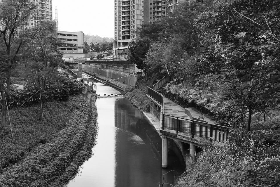
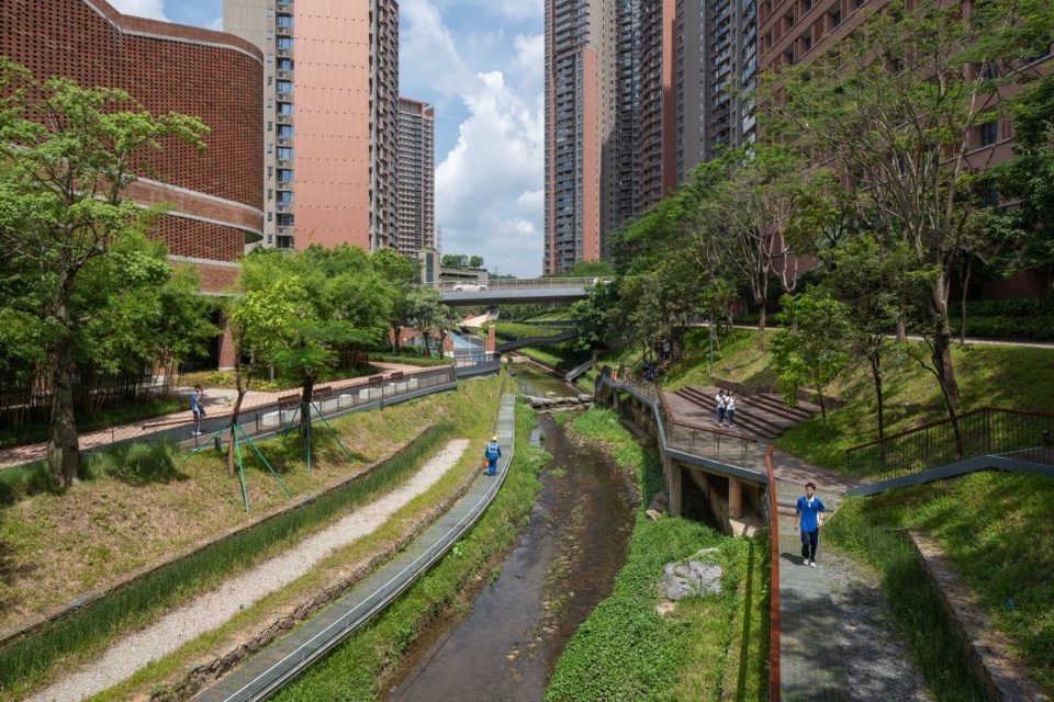
维持现状河道平面形态,更新既有栈道,并在另一侧现状石笼驳岸上部设置亲水步道,结合壅水堰改造形成汀步系统,联通两岸,让原本割裂的河道空间形成连续的通达性和空间识别性,引导师生安全亲近水面,观察水生生态;同时以堆石方式营造深潭浅滩,丰富河道生物多样性。
The design preserves the existing watercourse alignment, renews the boardwalk, and adds a waterside path above the existing gabion bank on the opposite side. A modified weir incorporates stepping stones to connect both banks, improving access and spatial continuity while allowing safe observation of aquatic life. Rock formations create deep pools and shallow riffles, enhancing aquatic biodiversity.
▼上游段剖面图(改造后),Upper Watercourse Section — After Renovation © NODE
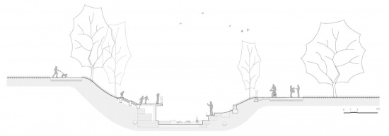
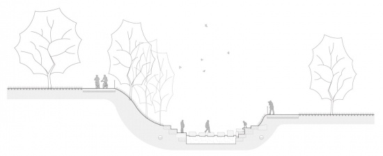
植物设计延续原有常绿乔木群落,结合上游水流平缓、水生环境稳定等条件,增加水生野趣植物,丰富景观效果的同时也吸引飞鸟、鱼虫来此处栖息,促进河岸生态系统的恢复与完整。克制的植物介入让水岸空间的生态属性得以自然感知。
The planting scheme preserves existing evergreen tree communities and introduces aquatic plants suited to the upper section’s gentle flow and stable habitat. These additions enrich the landscape, attract birds and aquatic life, and support riverbank ecosystem recovery. Restrained planting allows the watercourse’s ecological character to emerge naturally.
▼上游自然段,Upper Natural Section © 樊钊明 / Fan Zhaoming
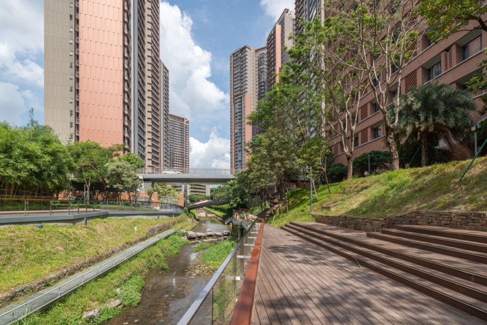
▼上游自然段,Upper Natural Section © 樊钊明 / Fan Zhaoming
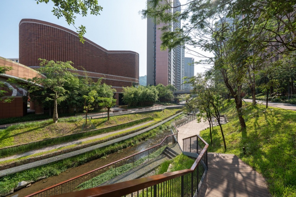
中游人文段 | 校园通行与公共界面的交汇空间
Middle Cultural Section | Where Campus Circulation Meets Public Space
中游河段位于校园内两座跨河廊桥之间,是教学区与生活区之间的空间交界,现状河道虽被杂乱植被与封闭界面包围,但其具备良好的可达性、开敞的视线条件,也是河道与校园发生日常互动最直接交汇的区域,为植入交流、课堂及公共活动提供了天然基础。
Located between two bridges within the campus, the middle section lies at the boundary between teaching and residential areas. Despite being enclosed by overgrown vegetation and barriers, it offers good accessibility and open views, making it a natural meeting point between the watercourse and campus life, well suited for social interaction, outdoor classes, and public activities.
▼中游人文段改造前后,Middle cultural section before and after renovation © NODE & 樊钊明 / Fan Zhaoming
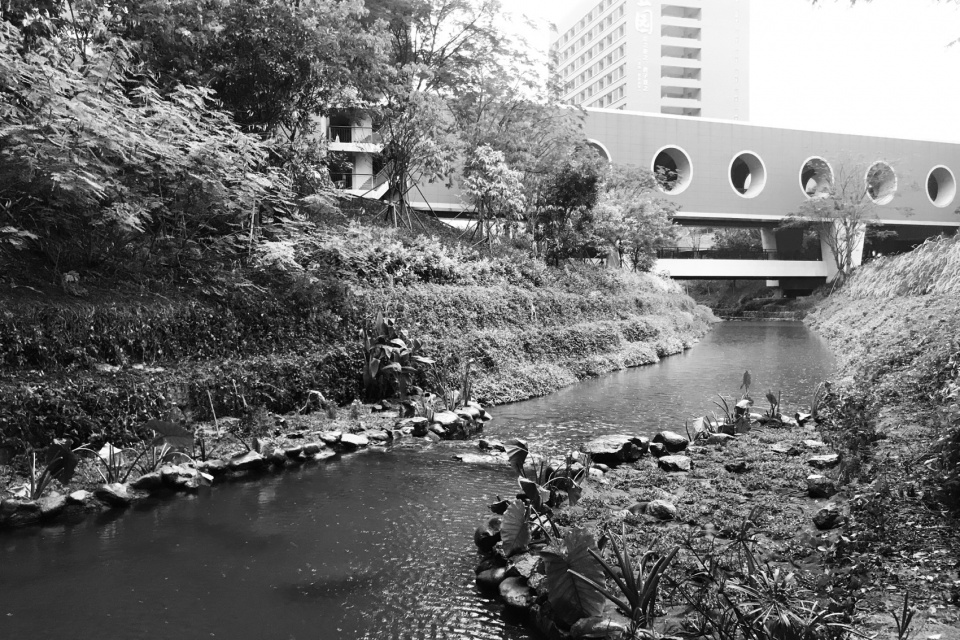
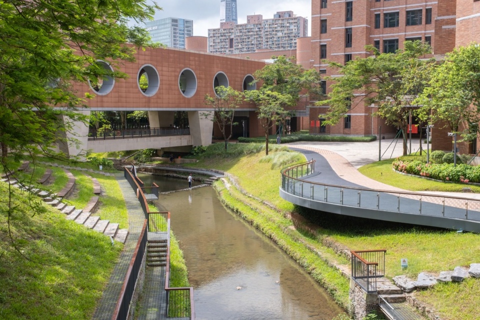
处于校园中轴线与河道景观的交汇处,设计结合校园主路径与跨河廊桥的空间关系,构建连续多样的停留场景。左岸放缓坡度,改造为阶梯坡,并局部拆除石笼,增设1.5米宽滨水步道,消解河道“深切难以接近”的感觉。作为深圳中学精神与文化象征的凤凰木种植于阶梯坡上,树下设置休息与观赏节点;对岸校园主路径交汇处设置270°弧形悬挑观景平台,两处节点隔河相望,形成空间上的对视与对话。
▼中游段剖面图(改造后),
Middle Watercourse Section— Section After Renovation © NODE
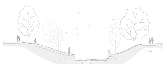
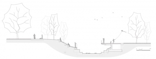
At the intersection of the campus axis and watercourse, the design connects the main campus path with the cross-river bridges to create varied spaces for gathering. On the left bank, the slope is softened into stepped terraces, with sections of gabion removed to add a 1.5-meter-wide waterside path, making the watercourse more accessible. A flame tree, a symbol of the school’s identity, stands on the stepped slope, with seating and viewing points beneath it. Opposite, a 270-degree cantilevered viewing platform marks the junction of campus paths. The two spaces face each other across the water, creating a visual dialogue.
▼观景平台与休憩节点隔岸相望,Viewing Platform and Resting Area Facing Each Other Across the Watercourse © 樊钊明 / Fan Zhaoming
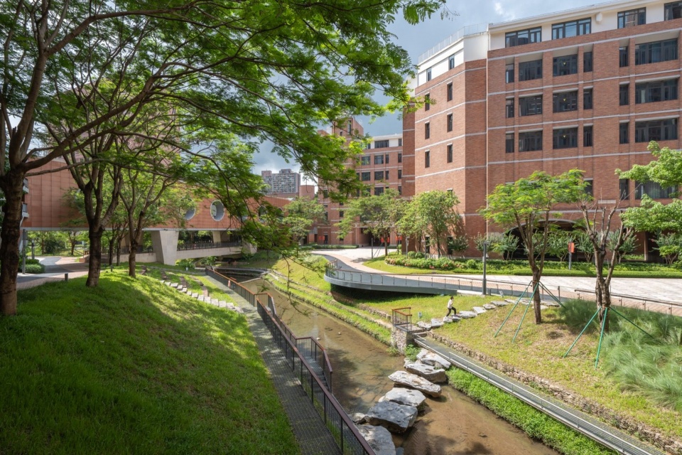
▼观景平台与休憩节点隔岸相望,Viewing Platform and Resting Area Facing Each Other Across the Watercourse © 樊钊明 / Fan Zhaoming
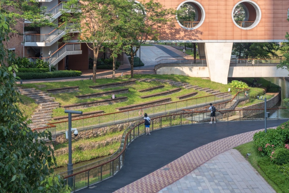
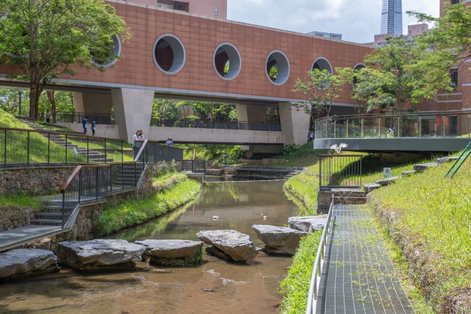
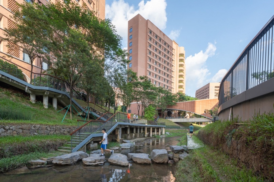
中游河段水流较急,且受两年一遇水位线控制,河道在此形成明显的高差界面,设计利用这一竖向变化,在保障行洪安全的基础上,将两处壅水堰转化为汀步系统。既减缓水流冲击,又丰富河道空间层次。非洪期间,师生可沿汀步跨越水面,触摸水汽、聆听虫鸣,让人的视线、脚步与河流产生更为亲近的联系。
The middle section has faster flows and is constrained by the 1-in-2-year water level. The design uses this level difference to transform two weirs into stepping-stone crossings, reducing water impact while enriching the spatial layers. In dry periods, students and teachers can cross the water, feel the moisture in the air, and listen to insects, bringing them closer to the watercourse through sight, sound, and movement.
▼汀步结合高差跌水,Stepping Stones Integrated with Cascading Water Levels © 樊钊明 / Fan Zhaoming
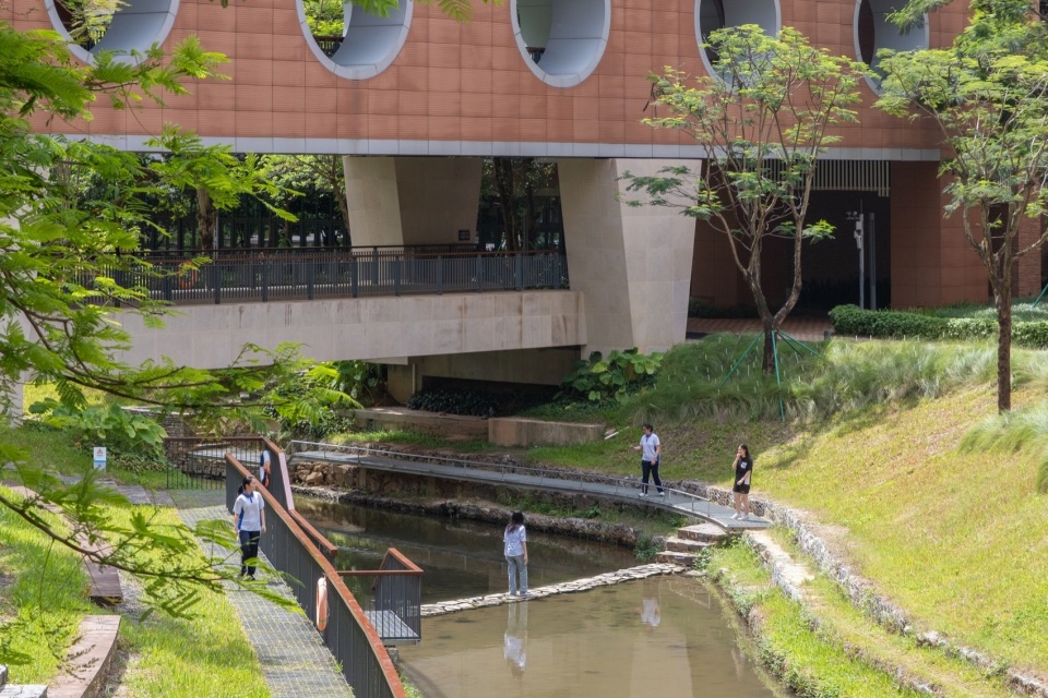
▼汀步结合高差跌水,Stepping Stones Integrated with Cascading Water Levels © 樊钊明 / Fan Zhaoming
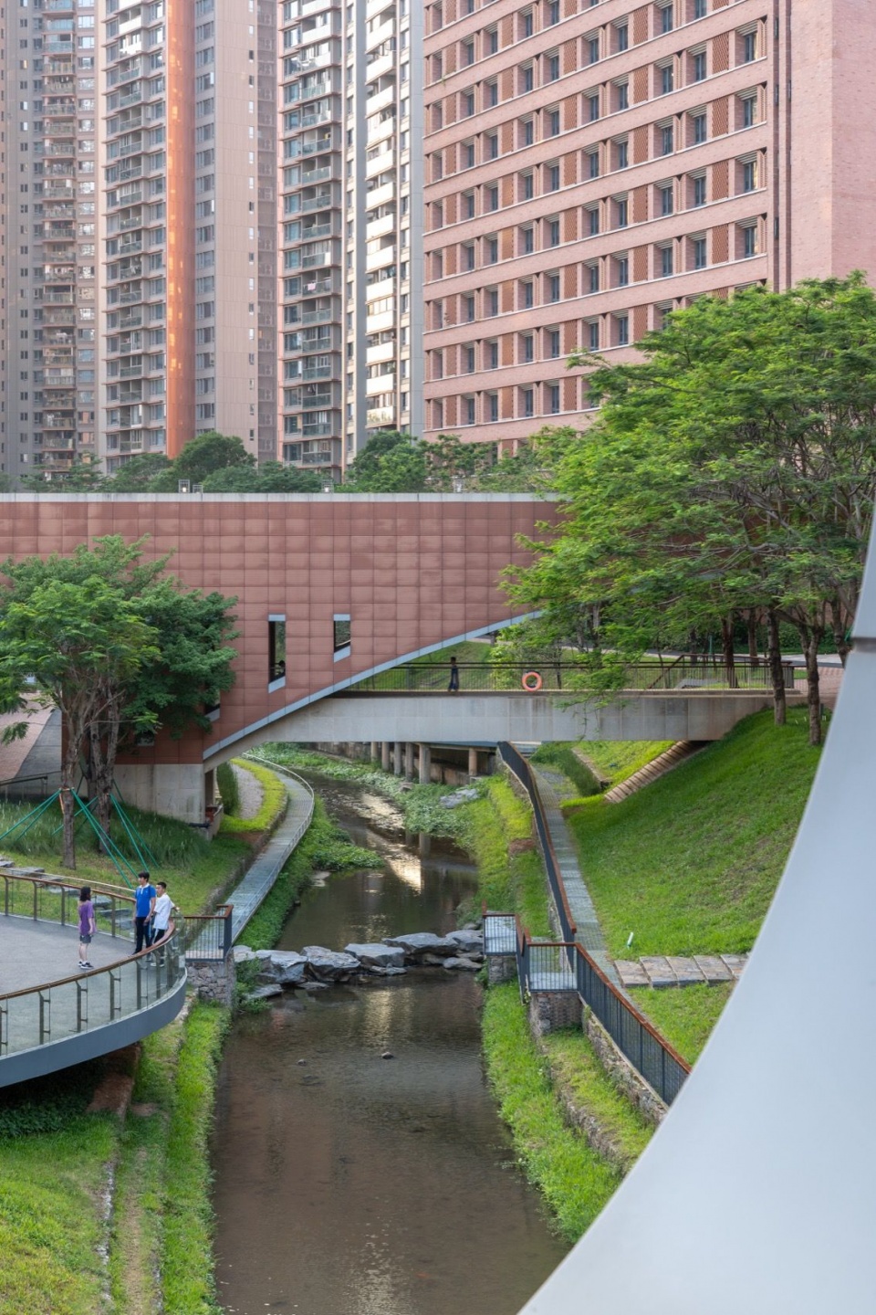
河段上的两座跨河廊桥在承担校园交通功能的同时,也成为观察自然的立体“取景器”。廊桥开口如同江南园林花窗的空间意境,师生在穿行过程中可俯瞰水岸变化。桥内与桥外互为景色,行走与停留彼此交织。
The two bridges across the watercourse serve both as campus links and elevated viewing frames for nature. Their openings evoke the framed views of traditional Jiangnan garden windows, allowing students and teachers to observe the changing waterfront as they pass. The bridge and its surroundings frame each other, blending movement with moments of pause.
▼从廊桥看向河道,View of the Watercourse from the Bridge © 樊钊明 / Fan Zhaoming
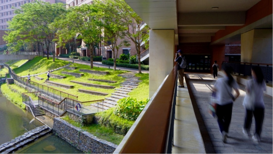
▼从廊桥看向河道,View of the Watercourse from the Bridge © 樊钊明 / Fan Zhaoming
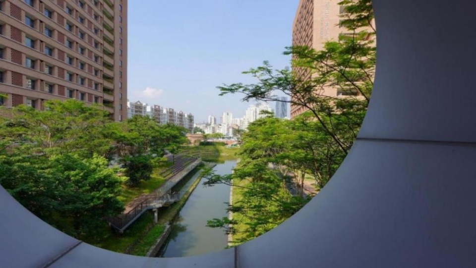
▼从廊桥看向河道,View of the Watercourse from the Bridge © 樊钊明
下游开放段 | 蓄水调蓄与开放水面
Lower Open Section | Water Storage and an Open Waterscape
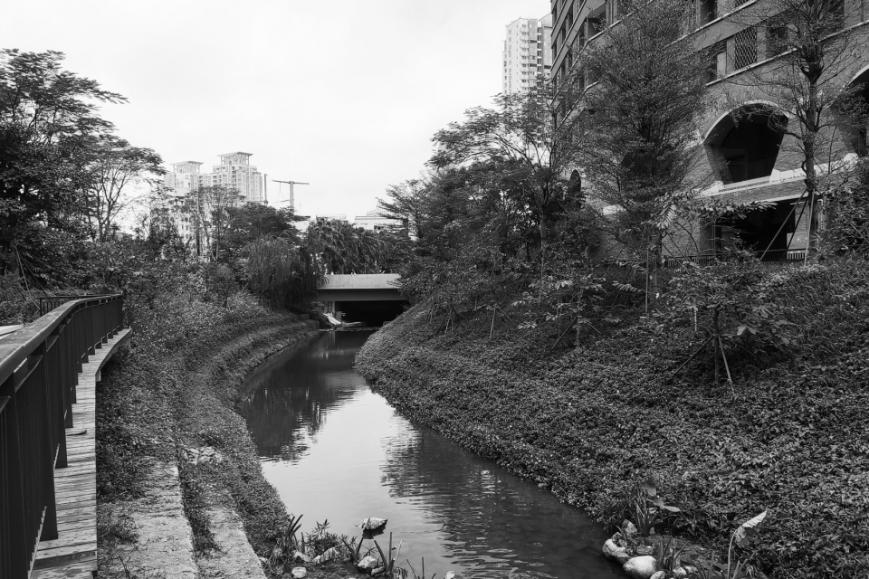
改造前的下游段延续上、中游河道的尺度,空间形态较为单一。一侧设有步道平台,另一侧坡面被自然疯长、已然肆虐侵入河岸边界的植物覆盖,依稀可见淹没在其中的闸门。水面尺度受限,人与水面之间存在一定距离,保持着场地原始而未被充分感知的状态。
Before renovation, the lower section retained the same narrow scale as the upper and middle reaches, with a relatively uniform spatial form. A walkway lined one bank, while overgrown vegetation engulfed the opposite slope and obscured a sluice gate. The limited water surface kept people at a distance, leaving the site’s original character largely unnoticed.
▼下游开放段改造前后,Lower open section before and after renovation © NODE & 樊钊明 / Fan Zhaoming
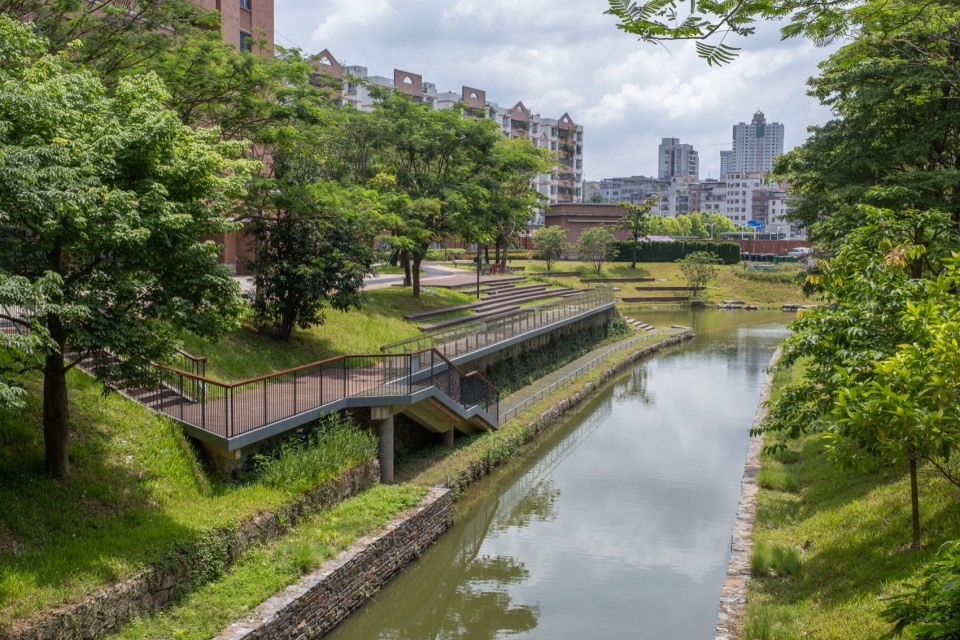
下游段以水利调蓄功能为改造重点,工程安全与景观水面形成统一结构,也让这里成为天然开放的科普课堂。在两年一遇水位线的控制下,河道东端设置壅水设施(水闸)调节水位,满足泄洪需求,并结合内循环泵与滤料池系统,维持水体自循环与水质稳定;局部拓宽左岸河道岸坡,造湖蓄水,弹性调控水体,并形成“从河道到湖面”的景观延展感。
▼下游段剖面图(改造后),Lower Watercourse Section
— Section After Renovation © NODE
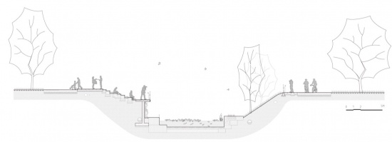
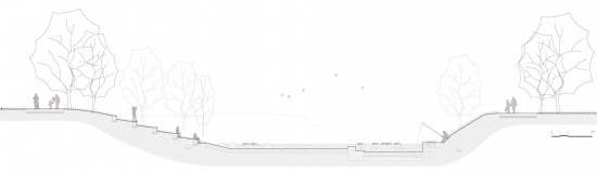
The lower section focuses on water storage and regulation, integrating flood safety with an open water landscape and an outdoor learning space. A sluice gate at the eastern end regulates water levels under the 1-in-2-year water level constraint, while a circulation pump and filter bed maintain water quality. Widening the left bank creates a pond for water storage and flexible level control, extending the landscape from a watercourse into an open water surface.
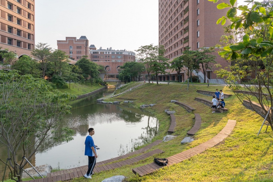
▼拓宽河道端部,形成“湖面空间”,Widening the Watercourse to Create a Lake-Like Space © 樊钊明 / Fan Zhaoming
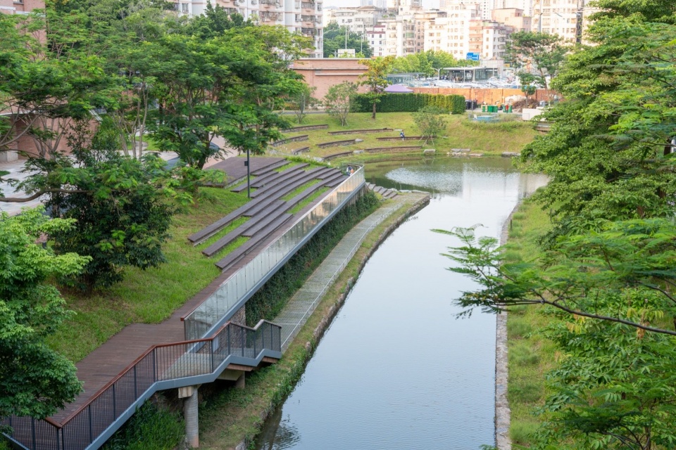
作为滨水廊道的终点,下游段以开阔水面展开视线,岸边的观鸟台阶与草坡广场由近及远延伸,使空间在行进末端豁然开朗,也为紧张的校园生活提供了一处停留与放松的场所,泛舟、交流、阅读,或片刻放空,日常活动在水岸边自然发生。 沿岸休憩平台集中种植白兰,常绿树冠与开放水面相互映衬,白兰稳定的开花节律为场地引入细微而可感的时间变化,花香、树影与水光共同营造出安静舒缓的氛围,自然生长与校园生活在此相遇。
As the endpoint of the waterfront corridor, the lower section opens onto a broad water surface, with birdwatching steps and a grassy plaza extending into the distance. The space offers a place to pause and unwind, where boating, conversation, and reading become part of daily campus life. White magnolias line the riverside platforms, their evergreen canopies framing the water. Seasonal blooms, fragrance, and shifting shadows bring subtle changes over time, creating a calm setting where nature and campus life meet.
▼拓宽河道端部,形成“湖面空间”,Widening the Watercourse to Create a Lake-Like Space © 樊钊明 / Fan Zhaoming
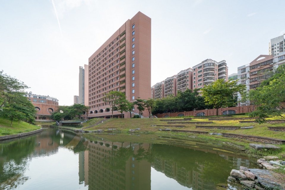
▼木兰树下、河湖景前,Beneath the Magnolia Trees, Overlooking the River © 樊钊明 / Fan Zhaoming
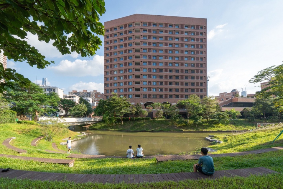
06 河道:校园内的“世外桃源”
The Watercourse: A Hidden Retreat Within the Campus
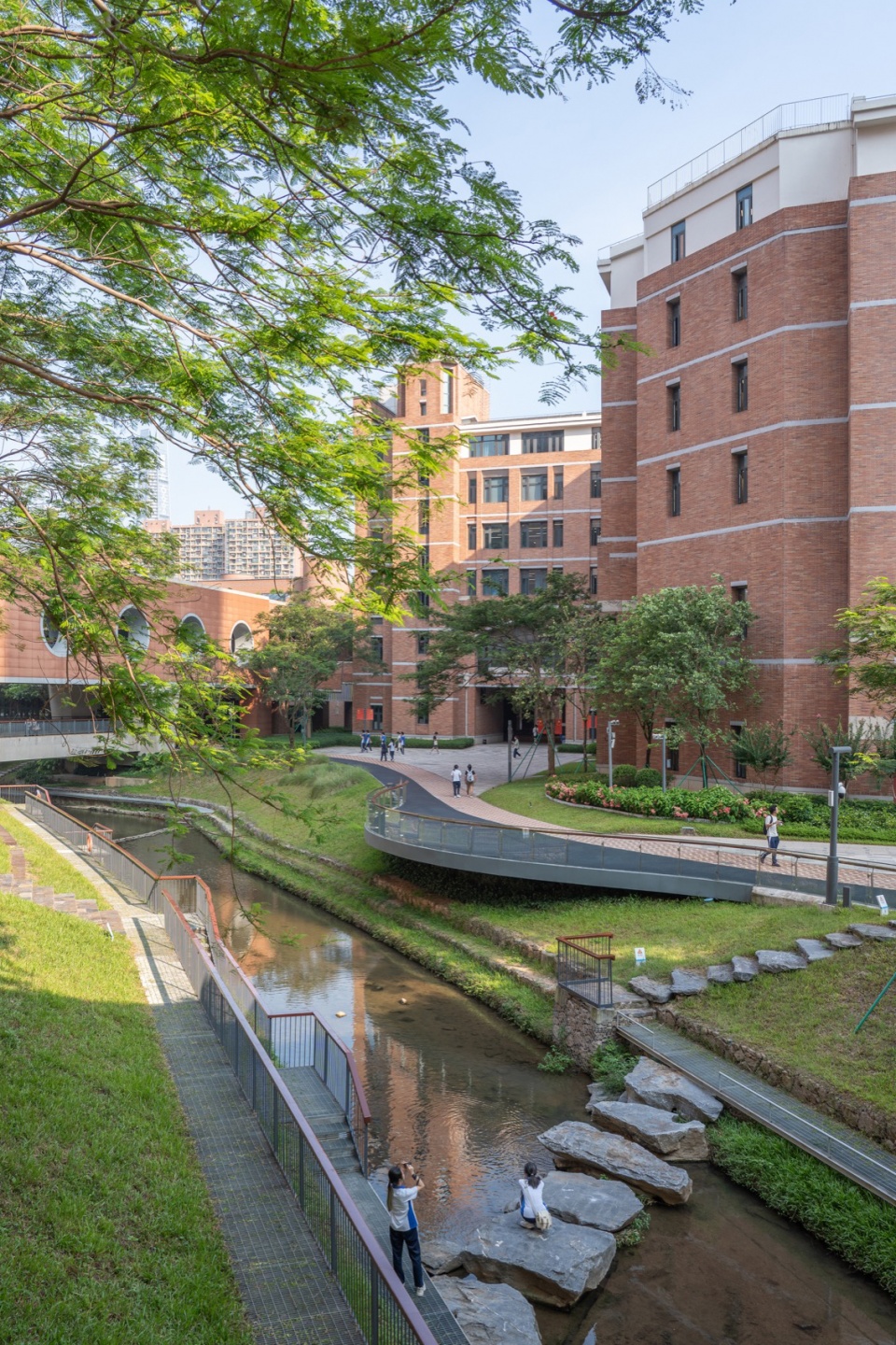
通过分段更新与整体统筹,笔架山河深圳中学(泥岗校区)段从单一行洪河道转变为融入校园日常的滨水空间系统,成为师生学习、交流、漫步与停留的公共场所。在满足防洪标准、提升行洪能力与生态条件的基础上,设计以克制细腻的方式营造近人尺度的滨水环境,让河流重新以开放、自然的方式融入校园生活。
Through phased renewal and integrated planning, the Bijia Shan River at Shenzhen Middle School’s Nigang Campus has been transformed from a floodway into a waterfront system woven into campus life. It provides spaces for learning, gathering, walking, and rest. While meeting flood protection standards and improving flow capacity and ecology, the design creates an inviting waterfront that reconnects the river with everyday campus life.
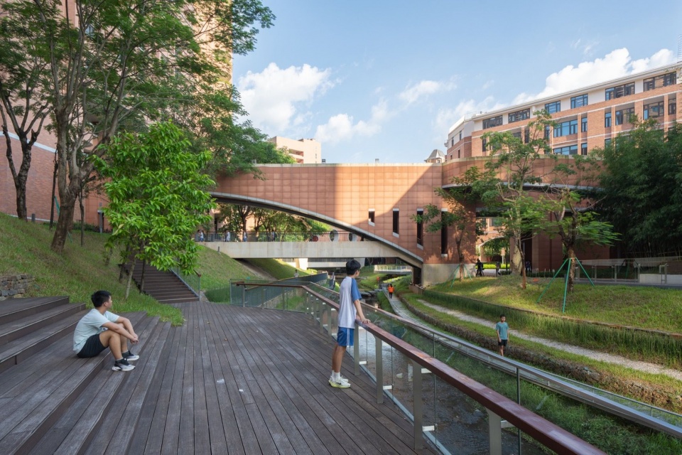
▼河道成为校园日常生活场景,The Watercourse as Part of Everyday Campus Life © 樊钊明 / Fan Zhaoming
深中段的这一次明渠活化试验,是一次关于工程河道公共价值的探索,尝试在工程安全、生态文明与公共开放之间寻求共生。此次改造并非单纯是景观环境提升,而是在保障水安全的基础上,探索曾经隐匿于城市运行背后的工程设施向生态环境、人文景观与城市公共空间融合转变的可能,即回应了一条水利河道的更新需求,也为城市暗渠复明提供了一次可验证的实践样本。
The daylighting of the Bijia Shan River at Shenzhen Middle School explores the public value of urban water infrastructure, seeking to reconcile flood safety, ecology, and public access. Beyond landscape improvement, the project integrates infrastructure into the campus environment and public realm, offering a practical model for urban watercourse daylighting.
▼河道成为校园日常生活场景,The Watercourse as Part of Everyday Campus Life © 樊钊明 / Fan Zhaoming
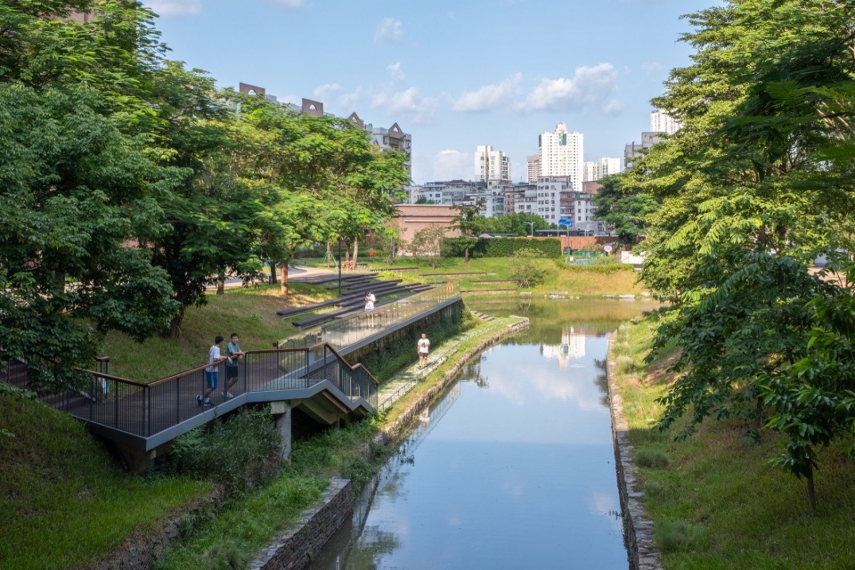
▼河道成为校园日常生活场景,The Watercourse as Part of Everyday Campus Life © 樊钊明 / Fan Zhaoming
① 笔架山河位于深圳市中心区,布吉河的一级支流,深圳河最大的二级支流,对深圳水质治理起到重要作用。笔架山河流经罗湖-福田两区高密度中心城区,其中福田区段1.08km,罗湖区段4.69km,与周边生活的居民没有直接联系。笔架山河属于“以排涝功能为主的河道”,规划内容主要为区域排涝和片区排水。
② 2020年,深圳水务局发布《深圳市碧道建设总体规划(2019-2035)》中提出,“将深圳碧道分为都市型、城镇型、郊野型三大类,并以“水产城共治”作为指导碧道建设的核心理念”。都市型河道,指发源或流经城市发展程度高的中心城区中自然式河道及人工式河道,河流暗渠暗涵比例高,上方往往建有住宅、商业、学校和配套设施等,河道两侧场地空间较为局促。
③ 都市型河道改造重点需要首先满足河道排洪滞洪的基本功能,尤其在南方城市夏季通常会有大暴雨情况发生,降水后如不能有效排放,容易造成汛期洪水或引起内涝问题。因此,行洪排涝问题需首先解决,优先发挥原有的河涌功能;在满足河道防洪排涝基本要求的基础上,以“面域”的角度进行景观设计。
① Bijia Shan River, located in central Shenzhen, is a primary tributary of the Buji River and the largest secondary tributary of the Shenzhen River. It plays an important role in water quality management. Flowing through the densely developed urban districts of Luohu and Futian, it extends 1.08 km in Futian and 4.69 km in Luohu, yet remains disconnected from surrounding communities. Classified primarily as a drainage watercourse, it is planned mainly for regional flood control and drainage.
② In 2020, the Shenzhen Water Affairs Bureau’s Overall Plan for Shenzhen Blueways (2019–2035) classified blueways into three types: urban, town, and suburban, guided by the principle of integrated governance of water, fisheries, and the city. Urban watercourses flow through highly developed central districts, often with extensive culverts and buildings above, including housing, commercial facilities, and schools. Space along their banks is typically limited.
③ Urban watercourse renewal must first ensure adequate flood conveyance and storage. In southern cities, intense summer rainfall can cause flooding and urban waterlogging if runoff is not discharged effectively. The existing drainage function should therefore take priority, with landscape design developed at the broader site scale once basic flood protection requirements are met.
项目名称:深圳中学泥岗校区河涌景观改造设计
项目类型:河道改造、景观设计
项目地点:深圳市罗湖区
建成状态:已建成
设计时间(起迄年月):2021年11月—2022年8月
建设时间(起迄年月):2022年5月—2025年1月
用地面积:18286 平方米
设计长度:约300米
设计牵头组织:深圳市水务规划设计院股份有限公司
初设团队:深圳市麓景园林景观设计有限公司
施工图设计单位:深圳市水务规划设计院股份有限公司
设计单位:南沙原创建筑设计工作室
主创建筑师:刘珩
设计团队:黄杰斌、黄赞宁、黄国良、刘雪
施工单位:广东省水利水电第三工程局有限公司
监理单位:深圳市深水兆业工程顾问有限公司
业主/建设单位:深圳河河湾流域管理中心
摄影:樊钊明
Project Name: Landscape Renewal of the Watercourse at Shenzhen Middle School, Nigang Campus
Project Type: Watercourse Renewal, Landscape Design
Project Location: Luohu District, Shenzhen, China
Project Status: Completed
Design Period: Nov 2021 – Aug 2022
Construction Period: May 2022 – Jan 2025
Site Area: 18,286 m²
Design Length: 300 m
Lead Design Organization: Shenzhen Water Planning & Design Institute Co., Ltd.
Preliminary Design Team: Shenzhen Lujing Landscape Design Co., Ltd.
Construction Drawing Design: Shenzhen Water Planning & Design Institute Co., Ltd.
Design Organization: NODE Architecture & Urbanism
Lead Architect: Doreen Heng Liu
Design Team: Huang Jiebing, Huang Zanning, Huang Guoliang, Liu Xue
Construction: Guangdong No. 3 Hydropower Engineering Bureau Co., Ltd.
Supervision: Shenzhen Shenshui Zhaoye Engineering Consulting Co., Ltd.
Clients: Shenzhen River Bay Basin Management Center
Photography: Fan Zhaoming
More:南沙原创建筑设计工作室。更多关于他们:NODE Architecture & Urbanism on gooood








河道景观做得很棒