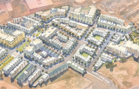
“This project went from macro to micro: from what we do at the city level to what we do on each doorstep. Solid urban design that used the typologies of housing, topography, and infrastructure, and ecology. A real urban vision. ”
—2011 Professional Awards Jury
“项目涉及范围从宏观到微观:城市尺度行为准则与家庭尺度行为准则。其强大的设计吸取住宅类型学,地形学,基础设施和生态学。是一个真正的都市景愿。”
2011年专业奖评审委员会
Hunters View Public Housing Neighborhood Redevelopment By GLS Landscape / Architecture and Daniel Solomon Design Partners, San Francisco
更多请至:GLS Landscape / Architecture on gooood, Daniel Solomon Design Partners, San Francisco on gooood
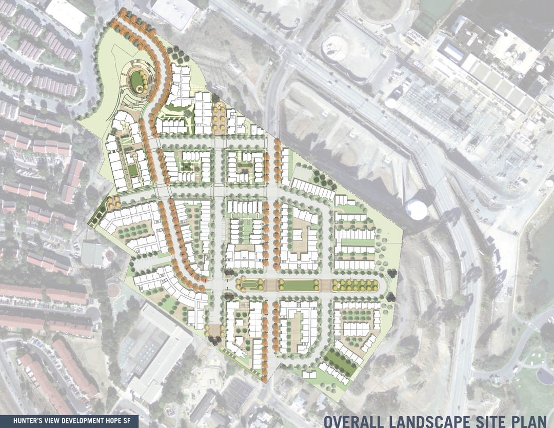
▲Overall Landscape Site Plan 总规
占地22英亩的Hunters View社会住房社区将成为旧金山最大的政府补贴社会住房公共社区。其全新的路网支持更高的密度和有趣的视野,和原有的低密度郊区规划相比,克服了与城市物理隔离的缺点,因此交通和服务将更为有效。这个项目获得了LEED社区银牌认证。旧金山没有比Hunters View社会住房社区更需要改观的社区了,项目用地在长期被忽略的城市东南角。它是Gavin Newsom市长率领的政府部门所制定的第一个重建项目,这个公私共同开发合伙项目替代了以前的方案。将原来267个条件不容乐观的住宅全部重建,并增添了250套商品房。
项目前身是1943建成的船厂工人临时住房,毫无设计原则,布局与外界缺乏联系。1954年,政府重新改建此地,加入街道,中间了部分住宅。重新的设计由于原有方案并体现了旧金山的特色。现有场地22英亩范围只有两个出入口,难以于警察和其它公共服务接壤,重建的主要目标是将孤立的场地与其它多个街区和人行道联系起来,沿着旧金山特有的陡峭地形进行布局,形成颇有冲击力的视
野。在主路的两端设置了两个主要的开放公园吸引邻里,新增的交通路线和人行道更深入将这个区域与周边联系。
附近各年龄段的居民都介入了这个规划,对开放公共空间,安全性和过程进行了参与。分期建设的房屋可以保证建设时不会有原有居民办理,场地更新是逐步进行的,最后完全完成。此外,按照旧金山的典型风格:不同收入和类型的公寓及社会性住房都是混合建设的。此外这个老年社区还包括社区设施和零售设施的规划。第一期(目前在建)包括3个街区的公共住宅和第一个椭圆形公园。 这个位于费尔法克斯主街上区的公园类似旧金山传统的棒球公园,拥有大型的草坪和荫凉的树影,地下还有大型的雨水收集箱,阶梯式景观上种植了可让社区儿童工作坊参与的果树和药材。尽管场地陡峭,阶梯式的设计和坡道圆满的解决了这个问题。
位于费尔法克斯主街南端最高点的狭长公园将在第二期和第三期建设,这个公园有着小小的圆形剧场,还可以直接欣赏到旧金山南湾的风景。这个公园遍布着一个个安全的内向型开放小空间,这些小空间相互的步行距离较短。街道设计拓展了旧金山街道优化准则,这个准则旨在让街道具有吸引力(促使人们步行到公共交通站点),并在多种范围内发挥作用:步行道,自行车道,树木,雨洪管
理,基础设施。基础设施的密度和地质情况影响树木布置,渗透性的路面收集雨水,最后将其排入到低位置的椭圆形公园储水箱,这些水将缓慢的释放进市政管网系统,以及用一部分为场地提供灌溉。
树木选择了适应地质土壤的寿命长低维护耐旱品种。不为行道树提供灌溉(加州地区都这样)。灌木和地被也是适应气候的本地植物。场地边界的植物恢复将使用到在场地清理时的植物现场贮备和种子贮备。街道和公园照明使用节能LED灯,项目获得了LEED ND银质认证。
Located on a 22 acre site, the Hunter’s View neighborhood will replace San Francisco’s worst public housing with new public housing subsidized by new streets, parks and market rate housing. A new street grid supporting higher densities and dramatic views will replace the low density suburban site plan, which has left the neighborhood socially isolated from San Francisco and physically isolated from transit and services. This project is certified LEED Neighborhood Development Silver.
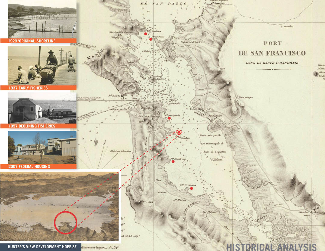
▲Historical Analysis 历史分析
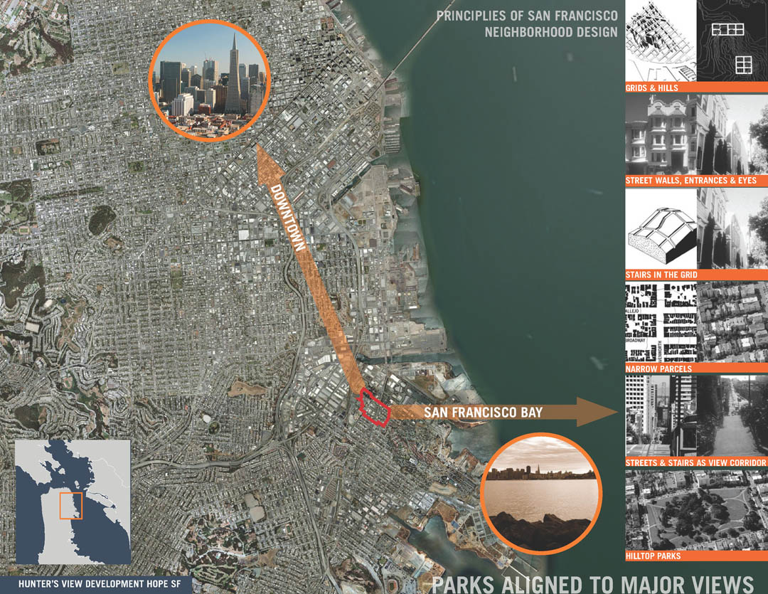
▲Parks Aligned to Major Views 两端公园的主要视野
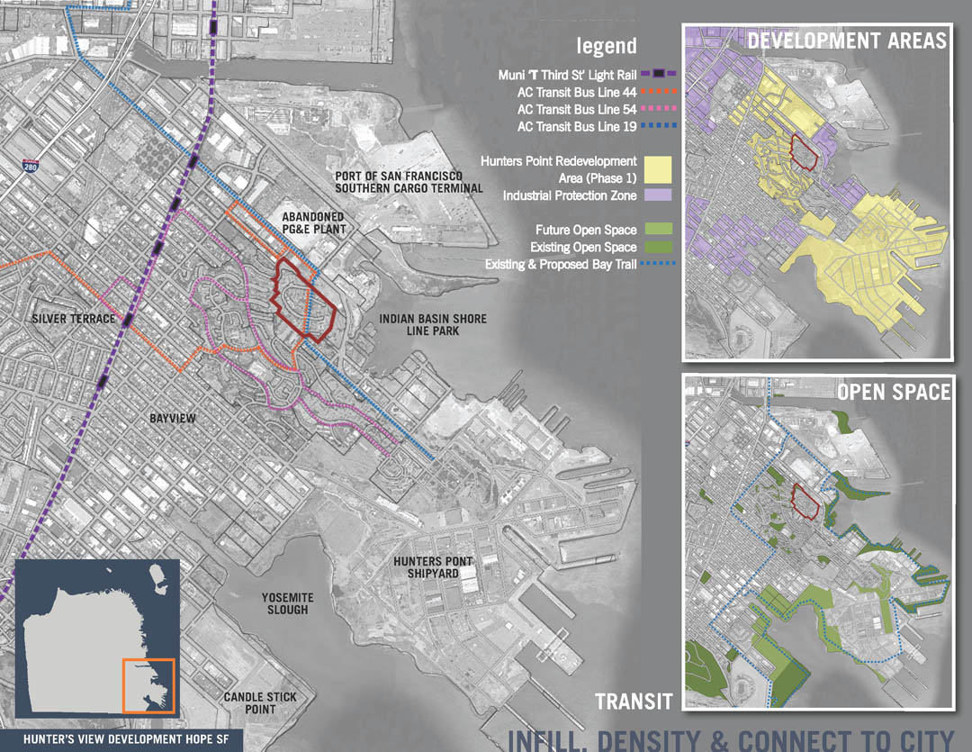
▲Infill, Density and Connect to City 内容,密度,与城市联系
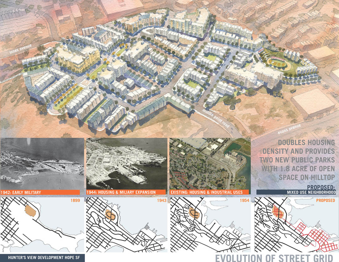
▲Evolution of Street Grid 路网演变
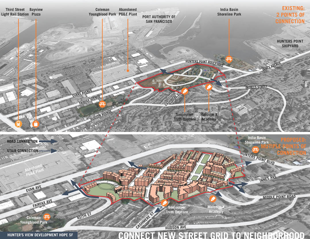
▲Connect New Street Grid to Neighborhood 与邻里路网联系
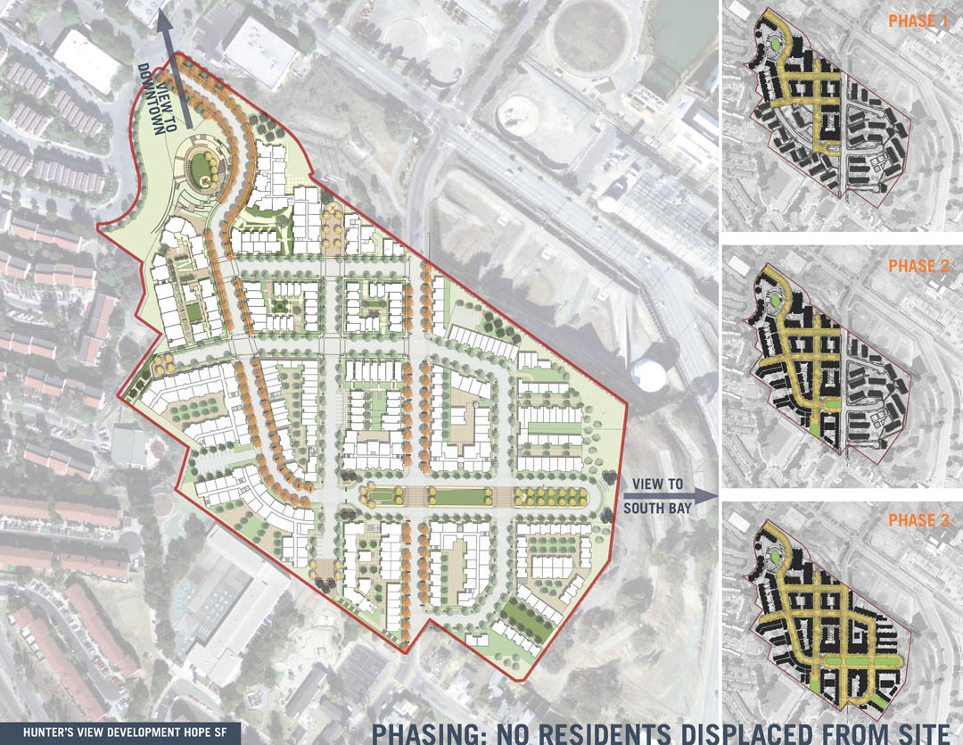
▲Phasing: No Residents Displaced From Site 分期建设

▲Open Space Plan & Serpentine Tolerant Planting 开放空间规划与种植设计
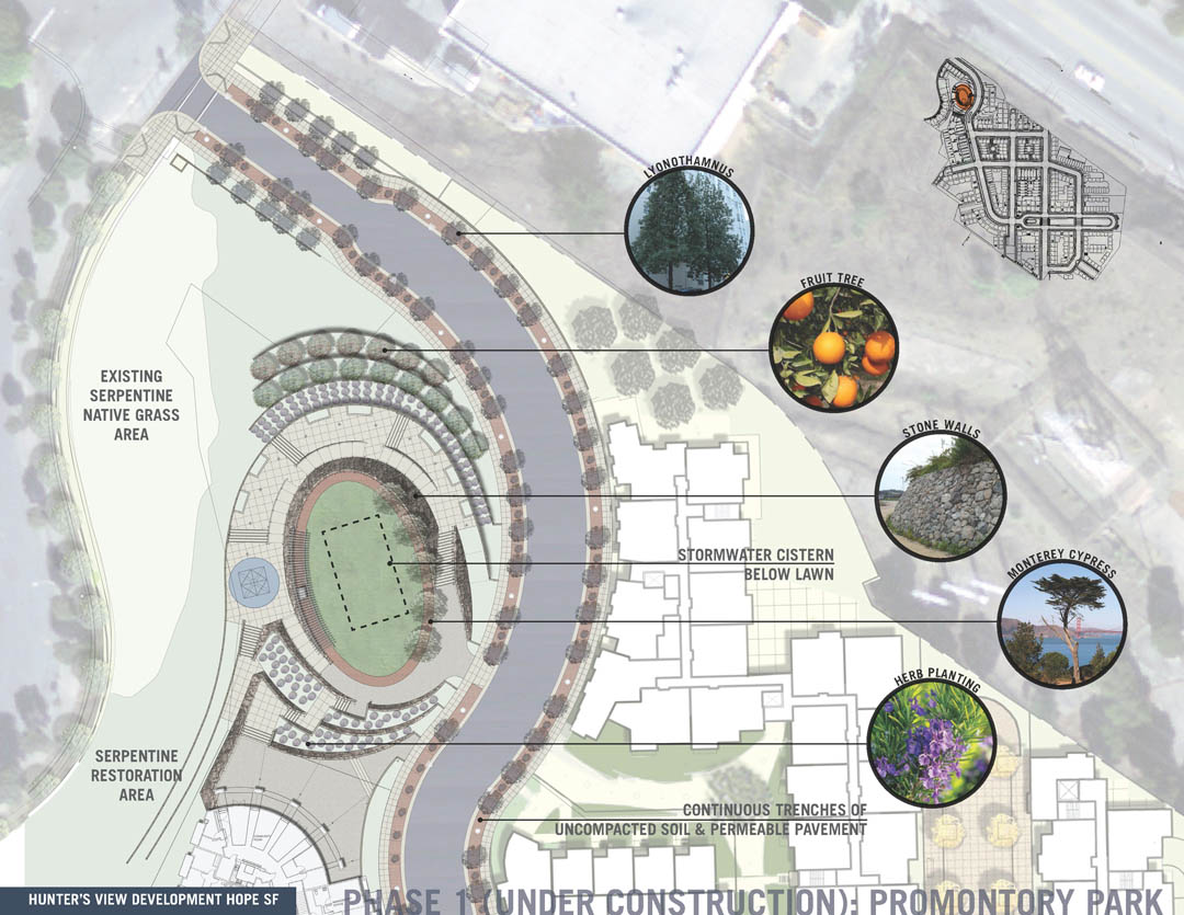
▲Phase 1 (Under Construction): Promontory Park 一期在建公园
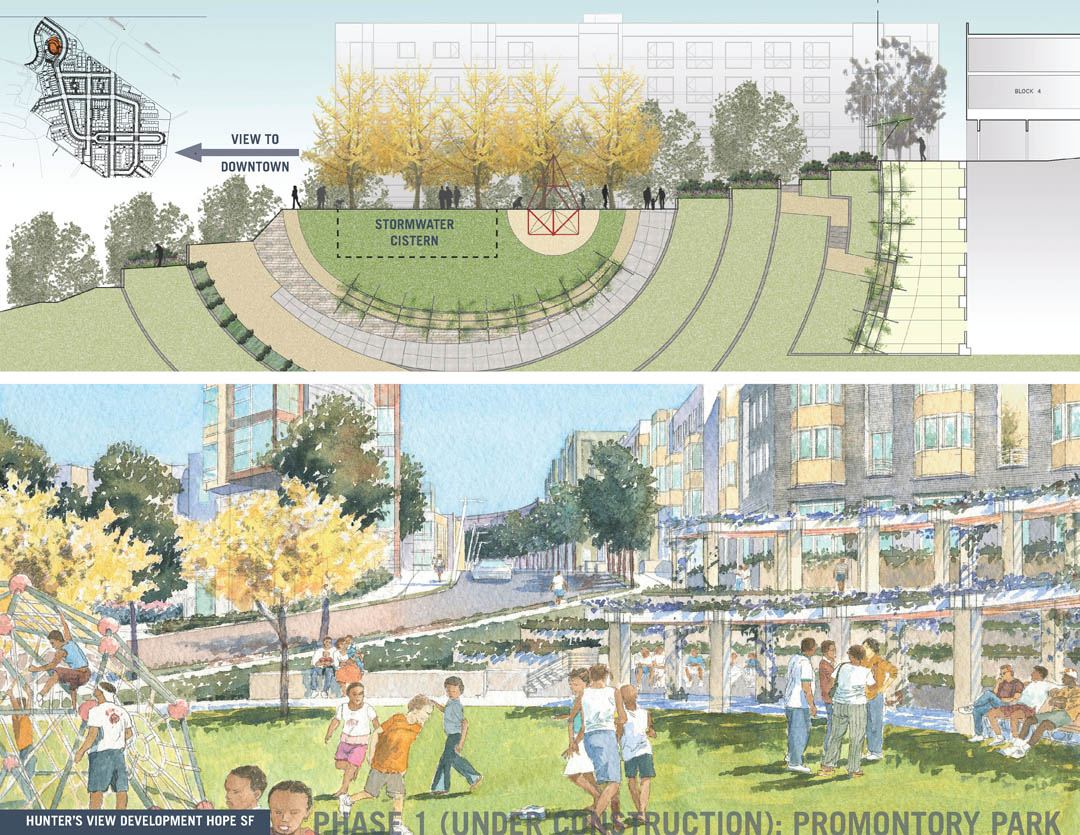
▲Phase 1 (Under Construction): Promontory Park一期在建公园
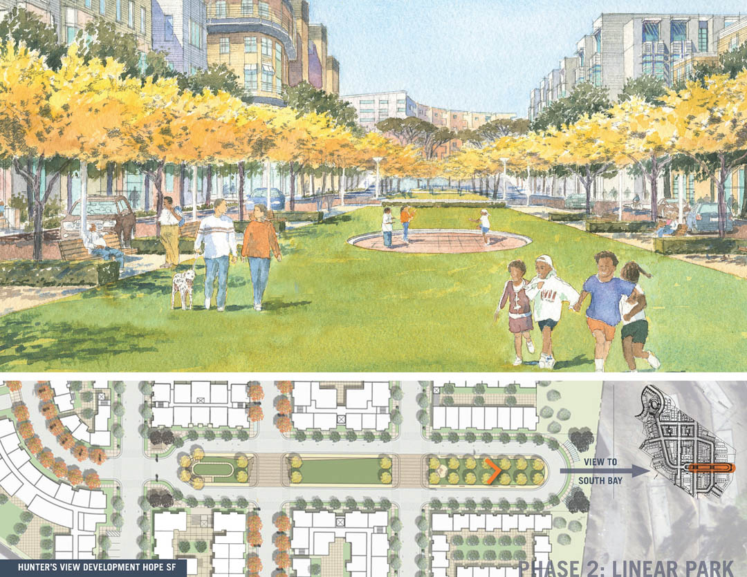
▲Phase 2 Linear Park 二期线性公园
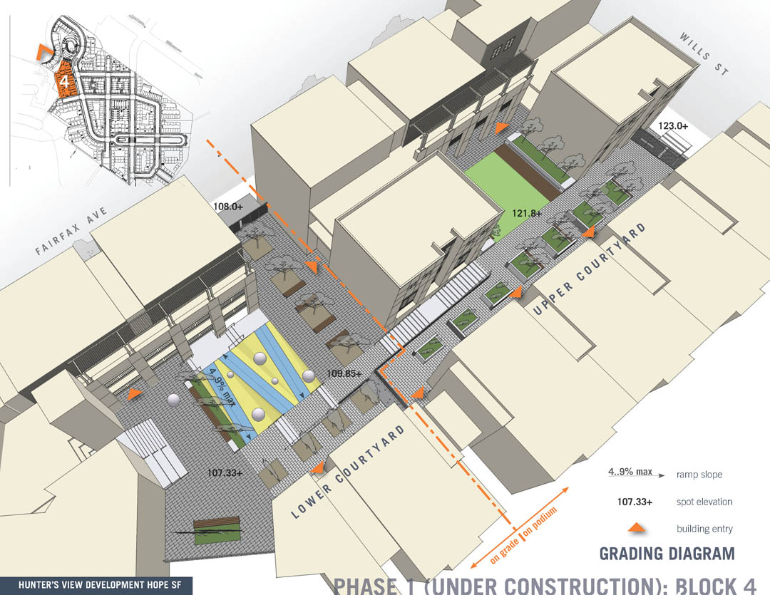
▲Phase 1 (Under Construction): Block 4 一期四区
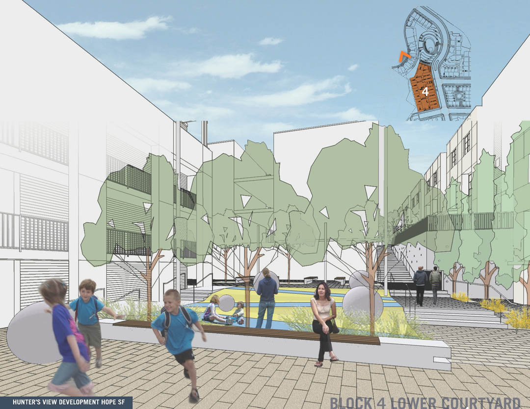
▲Block 4 Lower Courtyard 4区低地庭院
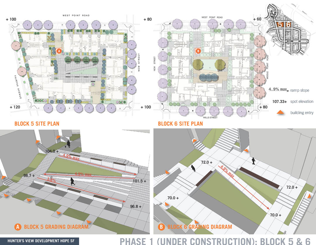
▲Phase 1 (Under Construction): Block 5 & 6 一期的五区和六区
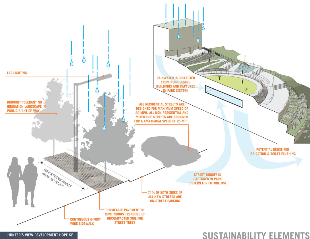
▲Sustainability Elements 可持续元素
Few neighborhoods in San Francisco are more in need of improvements and opportunities for its residents than the public housing project in Hunters View. Located on a hillside above the former Hunters Point Naval Shipyard in the City’s long neglected southeast corner, it was chosen by the Mayor Gavin Newsom’s Office of Housing, the San Francisco Housing Authority and the San Francisco Redevelopment Agency as the first reconstruction project to be undertaken by the City’s innovative HOPE SF Program. HOPE SF is a public/private partnership which combines city, state and federal funding with local developers to replace the abandoned federal HOPE IV program. The Hunters View Neighborhood project aims to replace 267 units of poorly maintained, partially abandoned and federally owned housing with new housing, which will be subsidized by an additional 250 units of market rate housing.
Originally built as part of the war effort in 1943 as temporary worker housing for nearby shipyards, the site was developed without attention to typical San Francisco design principals. Curving streets follow contours according to expediency resulting in few connections to the surrounding neighborhood. In 1954, the San Francisco Public Housing Authority converted the site to public housing, reusing the poorly designed streets and rebuilding some housing on many of the foundations intended to be temporary.
The redesign of the Hunters View site meets or exceeds the original HOPE VI guidelines, many of which are based upon traditional methods of planning that created San Francisco’s distinctive character. The current neighborhood has only two points of access for the 22 acres, making it unsafe, and difficult to police or service with public transit. A primary goal of the reconstruction is to reconnect the isolated site to the surrounding neighborhood with multiple street and pedestrian connections. A new grid of streets fronted by building entrances frequently stepping along the site’s steep slopes will extend the San Francisco urban pattern with surprising and dramatic views.
Two new hilltop parks are oriented to views; one on axis to downtown and the other to the south bay. Public stairs and pedestrian linkages will further connect the site to the surrounding neighborhood and provide access to existing transit options. Residents of all ages, as well as members of the surrounding community, have participated in workshops and tours of parks and neighborhoods throughout the design process, and have provided input on the open space design, security and the construction phasing. By carefully phasing construction, current residents will not be required to relocate offsite at anytime during the process. Abandoned units will be repaired for temporary occupation so that residents in the construction area can relocate to those units until new units are complete. In the end, a mix of condominium owners, market rate renters, and renters of SF Housing Authority units will occupy the site. The plan provides for a mix of income levels and unit types on every street as is found in typical neighborhoods of San Francisco. Housing for seniors as well as community facilities and neighborhood retail are planned.
The first phase (currently under construction) consists of three blocks of public housing and the first oval shaped park. Promontory Park is similar to a traditional San Francisco hilltop park. It is sited on axis with the main Fairfax Street and captures impressive downtown views from a large community lawn shaded with Monterey Cypress trees and a large stormwater storage tank below. Terraces are planted with fruit trees and herbs at the request of children attending community design workshops.
Despite the very steep slope, the majority of the developed site is accessible through the use of terraces and wide ramps. The linear Panhandle Park will be built in conjunction with the second and third phases of construction. Terminating Fairfax Avenue to the south at the highest point of the site, it has a tot lot and small amphitheater with views of the south bay. Every block has a secured but shared internal open space and several mews courts and smaller open spaces are distributed throughout the site, within short walking distance of every residence.
Street design furthers the recommendations of the San Francisco Better Streets Plan, which ensures that streets are inviting (so people will walk to public transit) and perform the multiple functions of accommodating pedestrians, bicycles, trees, stormwater management and infrastructure. Due to the density of infrastructure and the predominance of serpentine soils which have a dwarfing effect on trees, continuous trenches of specially site harvested and amended soils are provided in continuous uncompacted trenches and covered with pervious unit pavers. Stormwater from sidewalks drains to these pervious park strips between the sidewalk and the back of curb in the right of ways, while streets and housing blocks drain to a large cistern buried underneath Promontory Park. This water will be detained and slowly released to the City’s combined sewer system for treatment, and can be reused for irrigation in subsequent phases.
Trees have been selected for longevity, ease of maintenance, low water use and adaptability to existing serpentine soils. No irrigation (which is unheard of in California) will be provided in the right-of-ways. Shrub and ground cover plantings will be native and climate adapted Mediterranean plantings. Restoration plantings along the sites borders will be based on site inventory and seed collection prior to site grading. Street and park lighting are low energy LED fixtures and the project is Certified LEED ND Silver.
更多请至:GLS Landscape / Architecture on gooood, Daniel Solomon Design Partners, San Francisco on gooo
VIA:ASLA







水彩好好看
水彩渲染真的太漂亮了233
66
很喜欢那张效果图(水粉??)。不过细节太少了····不够看呀。
两张手绘画的漂亮~
[纠结]
实用主义
图形设计很好,直观、形象、细节分明
条理清晰,表达合理,值得学习