“利用无人机和地面摄影、即时的日志记录和实地测绘,定期进行细致的观察和取样。草甸计划旨在重新创造消失已久的栖息地,增加生物多样性,为南方传统的、整齐有序的景观审美提供一种相反的范例,同时增加该地区的生态与文化价值。”
– 2022年评审委员会“Careful observation and sampling occur regularly using drone and ground photography, active journaling, and field drawing. The meadows initiative aims to recreate long-lost habitat, increase biodiversity, and offer a counter example to the traditional manicured landscape aesthetic of the south, while providing ecological and cultural value to the region.”
– 2022 Awards Jury
来自 ASLA 对gooood的分享。
Alabama Meadows | Emily Knox + David Hill
项目陈述
Project Statement
阿拉巴马州草甸研究项目是一个基于实地环境的研究项目,旨在重新创造已经大面积消失的东南部草地景观类型。该项目利用扎根理论方法,指导了位于阿拉巴马州的Mary Olive Thomas示范林地中的五个草甸试验区的设置和维护。尽管一直处于被误解和低估的状态,被重新引入南部景观的草甸和草地将有可能为该地区带来惊人的生态和文化价值。通过长时间的实地作业、劳动和细致观察,该研究计划试图积累重新创建消失已久的栖息地的实地经验,增加生物多样性,并为南方整齐且静态的景观审美提出反例。
Alabama Meadows is a field-based research project that seeks to re-build knowledge about the largely eradicated southeastern meadow landscape typology. The project uses grounded theory to guide the installation and maintenance of five meadow test plots at the Mary Olive Thomas Demonstration Forest in Auburn, Alabama. Though historically misunderstood and under-valued, the re-introduction of meadows and grasslands to the southern landscape has the potential to provide incredible ecological and cultural value to the region. Through hours of field work, labor, and careful observation, this research initiative attempts to build on-the-ground experience in re-creating long-lost habitat, increasing biodiversity and providing a counter to the traditional manicured and static landscape aesthetic of the south.
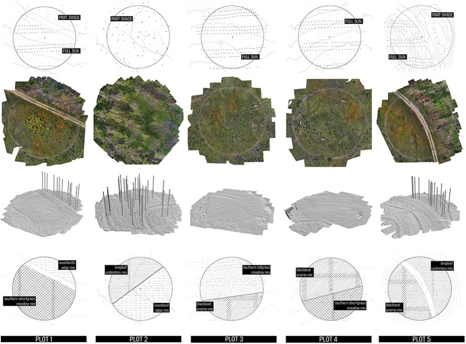
▲场地变量和地块微气候:每个150英尺的试验地块都具有特定的朝向、土壤条件、水流和风向。引入不同步的物种组合层和干扰项旨在提供一系列复杂的可观测值。SITE VARIABLES AND PLOT MICROCLIMATES. Each 150’ test plot was located to amplify a particular solar orientation, soil condition, hydrological flow, and wind exposure. Asynchronous layers of species mixes and disturbance regimes are introduced to provide a complex collection of observable intensities. © Emily Knox + David Hill
项目说明
Project Narrative
背景
草甸和草地曾经是阿拉巴马州最为欣欣向荣的景观类型。在历史上,这些以草和非禾本草本植物为主的景观曾为数以千计的本地物种和特殊物种提供栖息地,包括传粉者、昆虫和小型哺乳动物。在整个南方地区,为了给商业楼群和住宅等“高价值”的开发项目让步,原本广阔无垠的草坪大部分遭到了清除或者改造。这些景观赖以生存的自然火源受到了抑制,使现状变得更糟。根据“东南地区草原倡议”(SGI)中的数据,草甸和草地在整个地区中的占比已减少到从前的10%。这类重要栖息地的消失对于该地区的生物多样性造成了巨大的影响。草甸和草地是生态多样性的重要场域,即便是零碎的小块草地,也能为许多生物提供“种子库”和安全的避风港。
我们对东南地区草甸类型的关注和倡导并非只在于生态方面,它也源于我们对草甸作为一种文化遗产的迷恋。在典型的、郊区化无序扩张的环境下,成片的野花和高草为南方井然有序的草地景观提供了另一种选择。草甸能够为该区域带来罕见的光泽与质感。在以受到管控的商业林地和农业用地为主的景观中,草地所营造的沉浸感及其独有的特征能够引发人们无限的遐想。
虽然人们对于草地和草甸的兴趣正在逐渐恢复,但由于相关知识的普遍缺乏,重新引入草地和草甸的工作依然进展缓慢且困难重重。关于如何适当种植草地或对其进行长期管理的文献极为不足,因而人们对草地的种植和维护往往还是采取传统且粗放的方法,例如土壤强化、灌溉和施肥等,这通常会导致不适宜的物种或入侵物种的繁殖,使真正被需要的草甸植物无法充分发挥其生长潜力。若要成功地引入这种景观类型,就必须测试并开发出合适的种植和维护策略。
扎根理论
阿拉巴马州草甸研究借鉴了“扎根理论”(Grounded Theory)的丰富方法。扎根理论由 Glaser和Strauss于1967年首次提出,其宗旨是让研究人员充分暴露在数据中,使其“扎根”于环境和具体的情况,从内部挖掘出研究发现。在多年之后,这种方法产生出了多种形式,但在本次研究中,该方法被真正地空间化。试验地块的设计并不是为了在种植之前证明或反驳某种特定的假设,而是为了让研究人员(和来访者)完全地沉浸在草地正在实时的第一手“数据”当中。随着时间的推移,通过对各种变量的现场分层和测试,这种“沉浸”的过程也将逐步实现。在整个项目中,对场地条件(太阳能、水文、土壤等)、物种选择、种植技术和管理制度进行不同的分层配置,使我们能够生成、观察和收集大量的数据集并从中学习。
2020年春季,项目团队在Mary Olive Thomas示范森林设置了五个试验地块。每个地块的设计都是为了产生一系列的梯度和分层条件,从而可以随着时间变化进行操作和观察。每个地块(一个直径为150英尺的圆)都位于示范森林内,以展示特定的太阳方位、土壤条件、水文流和/或风向。例如,4号地块位于完全暴露的南向斜坡上,而2号地块则位于火炬松林的斑驳树荫下。每种独特的小气候和场地条件都得到了细分,并混合播种了至少两种种子。五个地块总共播种了来自三个不同经销商的六种种子。在过去的两个生长季,每个地块都采取了不同的干扰机制,包括人工除草、过量播种、移植、割草和计划性的焚烧。举一个具体例子:3号地块被划分为多个区域,每个区域都接受了播种、清理、除草、移植、焚烧和割草等标准化的处理。这些操作在每个地块的每个区域累积形成了独一无二的条件。每一次人为的介入都是对既有的生长或衰退、物种组成和表现的回应。经过一段时间之后,这些持续的介入将构建出一个在空间和生态上不断变化的区域,项目团队可以在此基础上继续开展工作。
观察与测绘
众所周知,景观媒介通常难以捕捉并准确地呈现。该学科在很大程度上依赖于地点的静态表现,往往忽略了景观的丰富性和细微差别——它们是处于不断变化之中的。复杂的景观,如草甸和草地,往往被迫通过技术统治者的视角来简化并规范其组成部分和它们之间的相互作用。原型化的施工图纸产生了静态的施工对象;它们并不适合捕捉项目中那些瞬时性的情形,如草的季节性萌发、物种竞争和干湿交替等。阿拉巴马州草甸研究项目试图努力应对这些挑战并扩展学科工具,以便更好地记录和表现时间、程序和操作方式造成的变化,从而拥抱我们不断创造的景观的复杂性。
在不同的试验地块中定期进行细致的观察和取样。无人机摄影、地面摄影、实时日志和实地测绘等技术使研究人员不仅能够看到场地的变化,还能分析因为时间而被掩盖的各种关系。照片拍摄采用了固定的观察点和统一的框架。通过这些工具,研究人员可以比较在时间上相隔较远的事件,如高温火灾对下一季生长模式和物种构成的影响,或本地草种与入侵杂草之间的关系。一系列照片、图纸和人工文物既提供了解草地的工具,同时也是一种挑战传统景观表现方法的机制。这项计划的研究范围远远超出了从实际种植和维护草地中吸取的经验。这些地块同时也是探索收集实地信息的新技术、提供第一手观察机会以及测试景观动态和时间变化的新策略的场所。
未来展望
在撰写本文时,阿拉巴马州草甸研究项目已进入第三个生长季节,春天的迹象已经初现。仅在这最开始的几年间,研究人员已经对场地准备策略、种植技术以及对大量草类和非禾本草本植物的特性和习性取得了深入的了解。这项工作和方法论还将持续三年或更久——虽然现在每块草地都已种植完成,但观察的重点将越来越多地集中在长期管理动态及其对物种分布和密度的影响上。随着每块草地的生长和发展,预期的研究还将扩展至对草地空间和美学品质的观察与传播。与草地的设置、随时间产生的变化以及空间质量相关的信息将继续服务于这一学科,并形成一套知识体系,帮助该地区的设计者与客户更容易地将草地和草原类型重新引入景观。
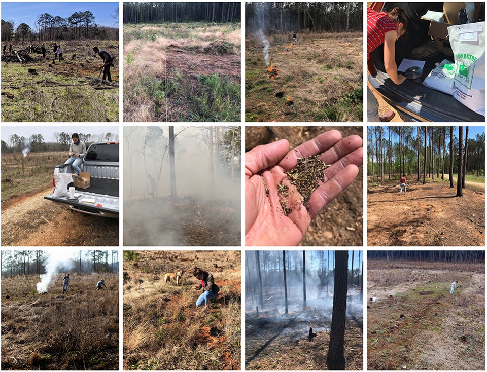
▲第一手观察:阿拉巴马州草甸研究项目借鉴了“扎根理论”(Grounded Theory),即完全地沉浸于景观“数据”之中。照片中,研究人员亲身在现场观察变化。 FIRST-HAND OBSERVATION. Borrowing from Grounded Theory, the Alabama Grasslands Research is about full-body immersion within the ‘data’ of the landscape. Researchers observe change on their hands and knees. © Emily Knox + David Hill
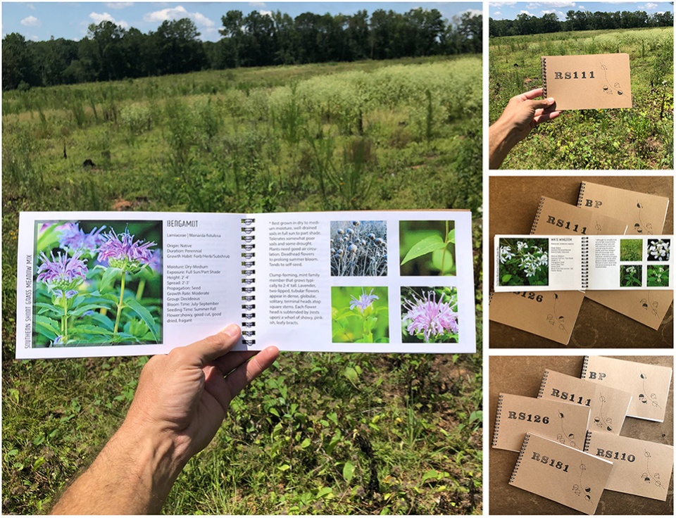
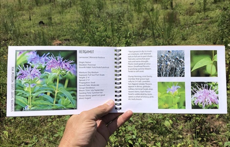
▲混合的物种:设计团队制作了图鉴笔记本,以识别不同生长阶段的物种。每种植物都会随着草地的变化而变化——随着时间的推移,它们会成为观察物种的出现、关系以及密度的实地记录。SPECIES MIXES. The design team created identification notebooks so that species could be identified at various stages of growth. Each evolves with the meadows – serving as a field record of observations about species emergence, relationships and density over time. © Emily Knox + David Hill
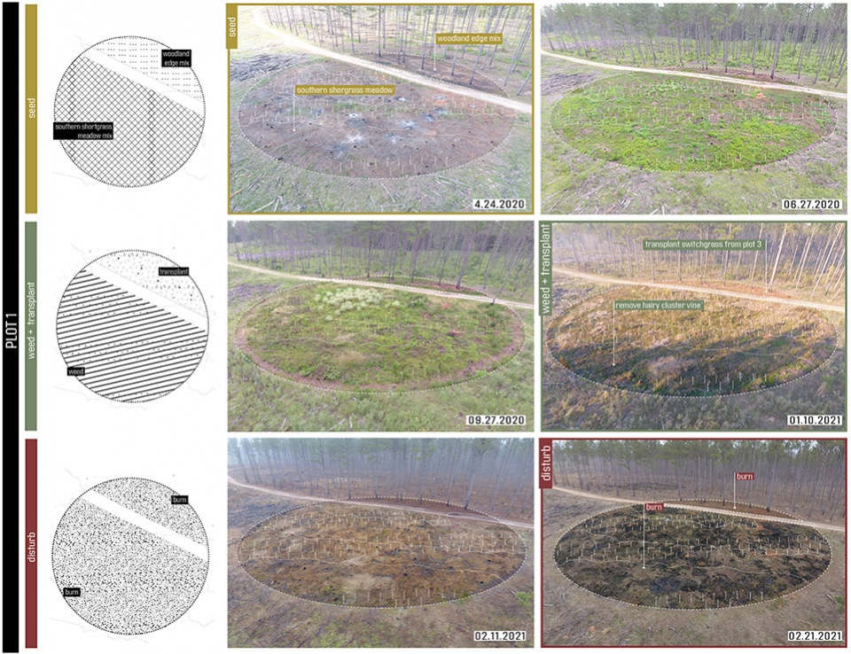
▲养护制度:在小区内进行了除草、移植、割草和焚烧等试验。研究小组不仅会观察地块内的关系变化,还会观察每个地块附近的种子移动情况。MAINTENANCE REGIMES. Experiments of weeding, transplanting, mowing, and burning were employed in zones within the plots. The team is not only watching for relationships that evolve within the plots, but also for seed movement adjacent to each plot. © Emily Knox + David Hill
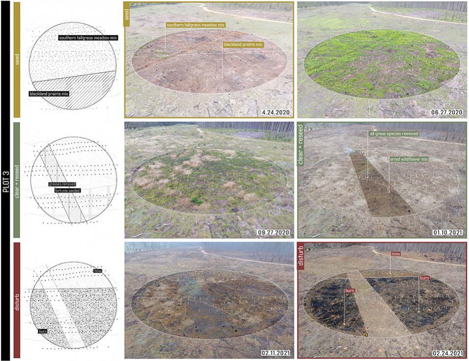
▲养护制度:在小区内进行了除草、移植、割草和焚烧等试验。研究小组不仅会观察地块内的关系变化,还会观察每个地块附近的种子移动情况。MAINTENANCE REGIMES. Experiments of weeding, transplanting, mowing, and burning were employed in zones within the plots. The team is not only watching for relationships that evolve within the plots, but also for seed movement adjacent to each plot. © Emily Knox + David Hill
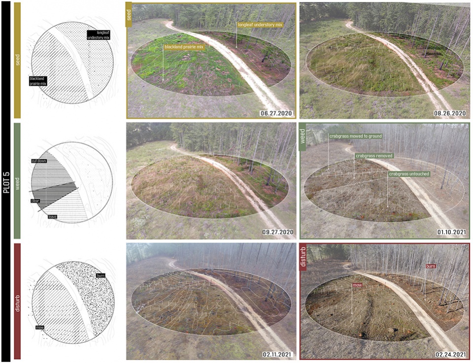
▲养护制度:在小区内进行了除草、移植、割草和焚烧等试验。研究小组不仅会观察地块内的关系变化,还会观察每个地块附近的种子移动情况。MAINTENANCE REGIMES. Experiments of weeding, transplanting, mowing, and burning were employed in zones within the plots. The team is not only watching for relationships that evolve within the plots, but also for seed movement adjacent to each plot. © Emily Knox + David Hill
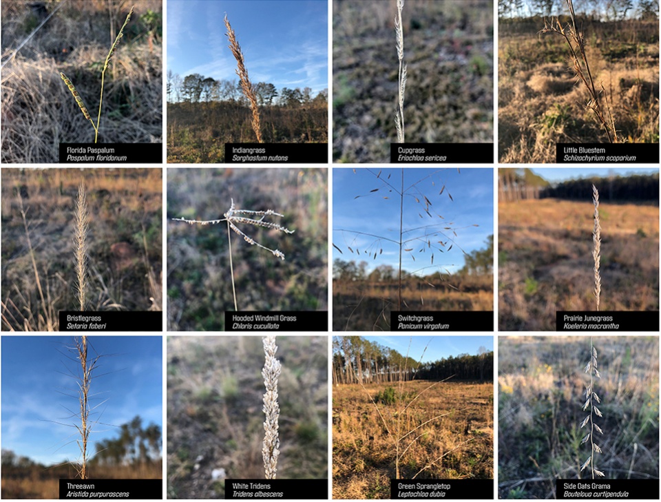
▲2020年11月24日的种头清单。在休眠期,禾本科植物和非禾本草本植物的种头提供了多种多样的纹理特征。 SEEDHEAD INVENTORY of 24 November 2020. At dormancy, grass and forb seedheads provide a diverse range of textural character. © Emily Knox + David Hill
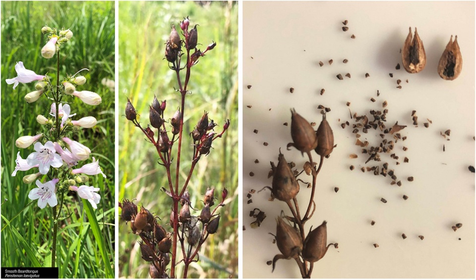
▲季节性的变化。记录单个物种从最初生到休眠的过程,捕捉独特的空间和纹理特征。SEASONAL SHIFTS. Individual species are documented from initial growth to dormancy, capturing distinct spatial and textural qualities. © Emily Knox + David Hill
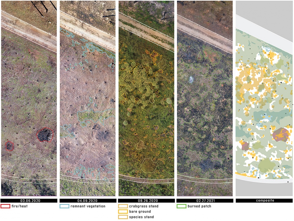
▲发掘历史的层次:利用无人机摄影和分析绘图,研究人员得以揭示出场地上被时间掩盖的关系。例如,1号地块中的追踪图像揭示了高温火灾、残余植被和新兴物种之间的动态关系。LAYERS OF HISTORY UNEARTHED. Using drone photography and analytical drawing, the researchers are able to reveal relationships obscured by time. As an example, the traced images within plot 1 interrogate the relationship between high temperature fires, remnant vegetation and emerging species dynamics. © Emily Knox + David Hill
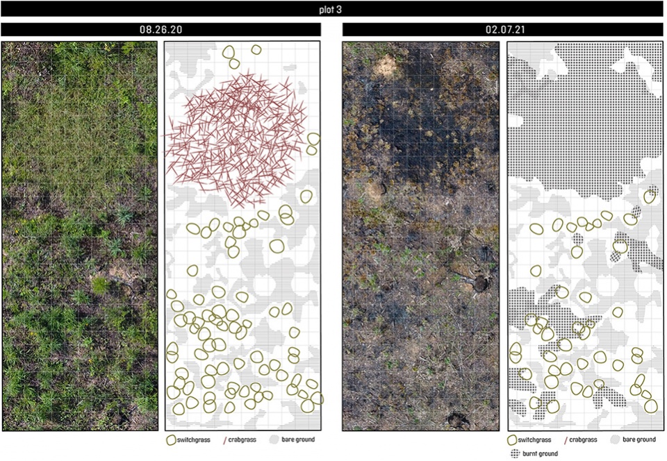
▲演变的层次:类似的技术也用于捕捉和揭示本地草种(柳枝稷)、访客物种(马唐草)和干扰机制(火)之间不断演变的关系。EVOLVING LAYERS. Similar techniques are used to capture and reveal the evolving relationships between a native grass species (Switchgrass), a visitors species (Crabgrass) and a disturbance regime (fire). © Emily Knox + David Hill
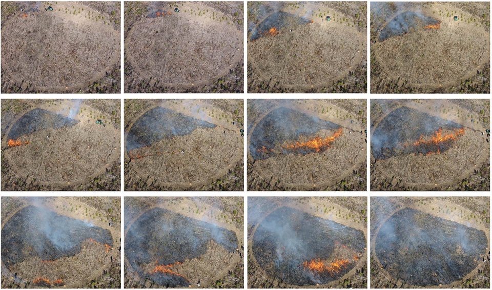
▲干扰机制:在每个地块引入不同的干扰机制,将对现有的植物密度做出反应,同时也会影响其未来的生长轨迹。DISTURBANCE REGIMES. Distinct disturbance regimes are introduced to each plot, both responding to the existing plant density and impacting future trajectories of growth. © Emily Knox + David Hill
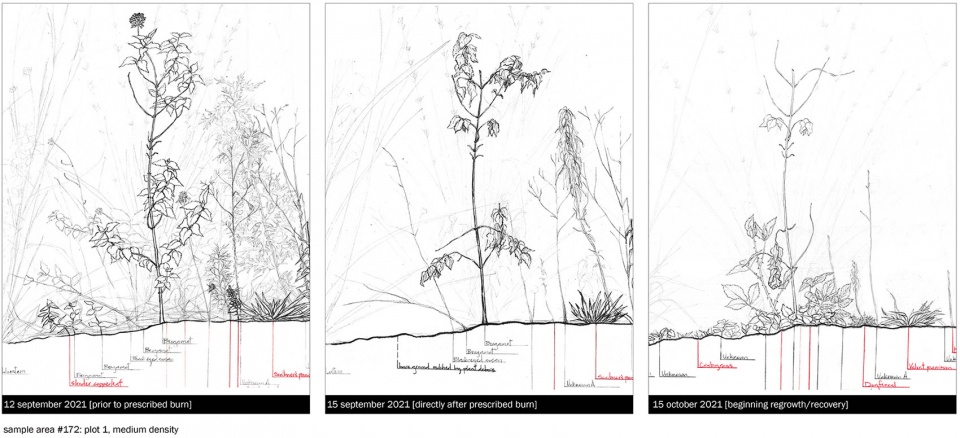
▲实地绘图:实地绘制试验地块的图纸,记录并分析植物密度、物种组成和不同干扰机制之间的关系——在本案例中,干扰机制是夏季有计划的焚烧。FIELD DRAWINGS. Field drawings of sample plots document and analyze the relationships between plant density, species compositions and distinct disturbance regimes – in this case, a summer prescribed burn. © Emily Knox + David Hill
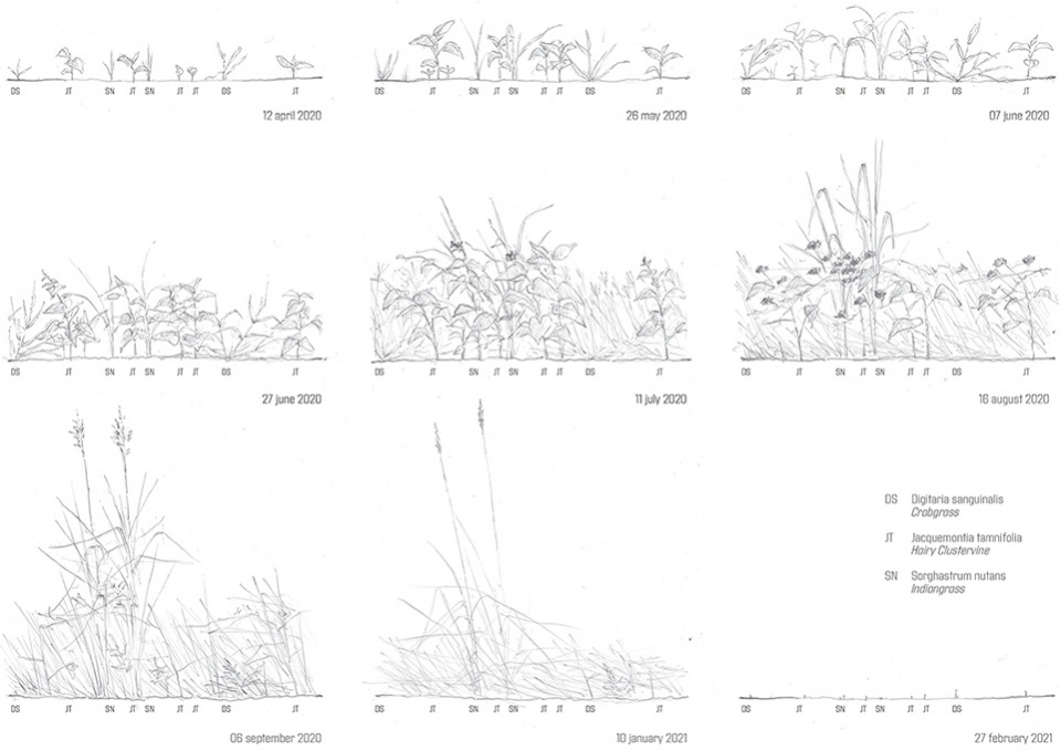
▲实地绘图。图片捕捉到了马唐草和毛丛生禾本科植物在裸露土壤中的定植情况,它们在第一年迅速生长,但在引入的混合种子的遮荫下并不具备竞争力。FIELD DRAWINGS. Field drawings capture crabgrass and hairy clustervine colonizing the bare soil, quickly advancing in the first year, but unable to compete in the shade of the introduced seed mixes. © Emily Knox + David Hill
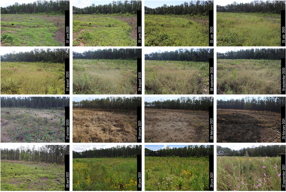
▲物候学研究:研究团队定期对每个地块进行定点拍摄,以捕捉新出现的植物生长和干扰机制所导致的空间和植物种类变化。PHENOLOGICAL STUDIES. Each plot is photographed from fixed stationpoints on a regular interval to capture the spatial and textural changes that result from the emerging plant growth and disturbance regimes. © Emily Knox + David Hill
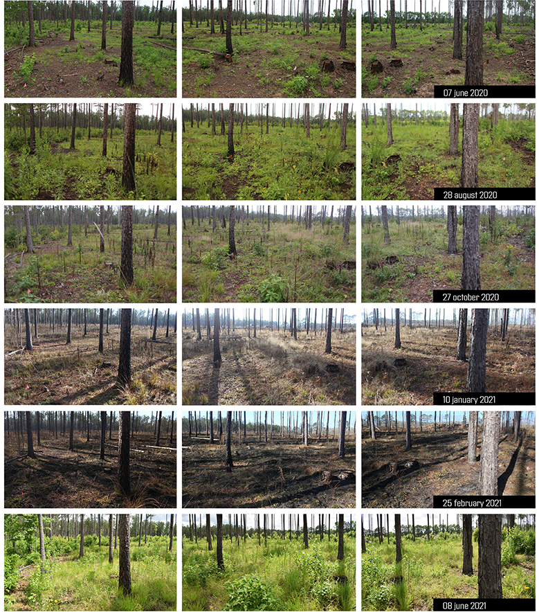
▲物候学研究:研究团队定期对每个地块进行定点拍摄,以捕捉新出现的植物生长和干扰机制所导致的空间和植物种类变化。PHENOLOGICAL STUDIES. Each plot is photographed from fixed stationpoints on a regular interval to capture the spatial and textural changes that result from the emerging plant growth and disturbance regimes. © Emily Knox + David Hill
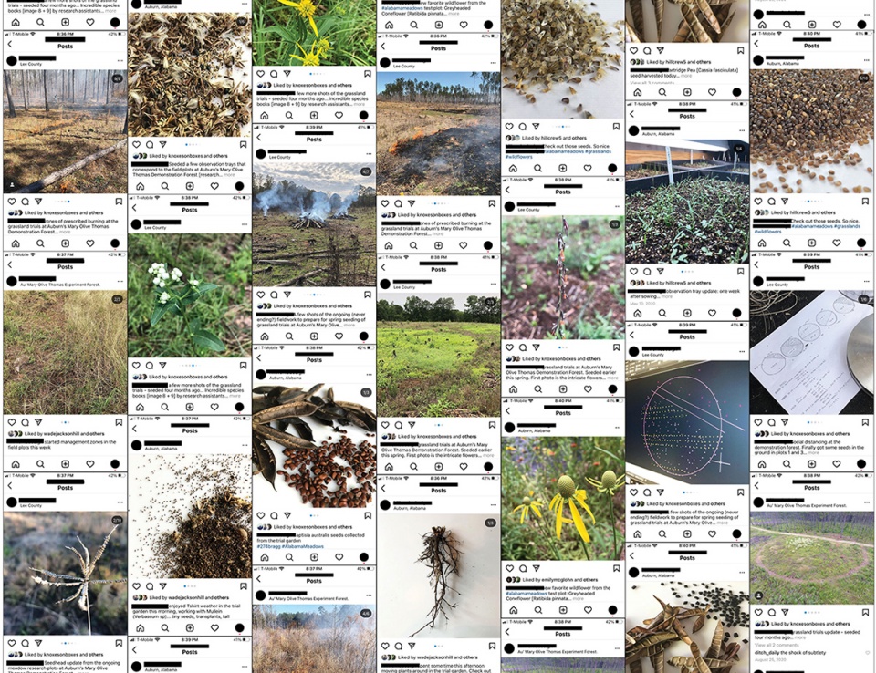
▲分享发现:通过社交媒体向任何对研究主题感兴趣的人分享每日的活动和发现。SHARING THE FINDINGS. Daily events and discoveries are shared through social media to anyone interested in the topic. © Emily Knox + David Hill
Project Narrative
BACKGROUND
Meadows and grasslands were once a thriving landscape typology in the state of Alabama. Historically, these grass and forb dominated landscapes were host to thousands of native and endemic species including pollinators, insects, and small mammals. Across the South, these once expansive landscapes have largely been converted or removed to make way for other “high value” uses like commercial forests and residential development. The suppression of natural fire, on which these landscapes depend, has only made matters worse. According to Southeastern Grasslands Initiative (SGI), meadows and grasslands occupy just 10% of their historic range in the across the region. The removal of this critical habitat has had an immense impact on regional biodiversity. Meadows and grasslands are critical hotspots for ecological diversity where even small, fragmented patches serve as a seedbank and safe haven for many species.
Our advocacy for and interest in the southeastern meadow typology is not purely ecological – it also lies in a fascination with meadows as a cultural artifact. Amidst the typical sprawling condition of suburbanization, patches of wildflowers and tall grasses offer an alternative to the static, controlled turf grass that permeates the south. Meadows provide richness in light and texture rarely witnessed in the region. In a landscape otherwise dominated by regimented commercial forestry and agriculture, grasslands provide immersion and otherness that have the capacity to captivate the imagination.
Though slowly re-gaining interest, a general lack of knowledge has made the re-introduction of grasslands and meadows slow and difficult. There is little documentation about appropriate installation methods or long term management, and thus, all too often meadows are installed and maintained like lawn or a field crop. Traditional, heavy-handed management, like soil enhancement, irrigation, and fertilization typically lead to the colonization of non-desirable and invasive species, which keep the intended meadow plants from reaching their full potential. If this typology is to be successfully re-introduced, appropriate installation and maintenance strategies must be tested and developed.
GROUNDED THEORY
The Alabama Meadows research borrows from the rich methodology of Grounded Theory. First described by Glaser and Strauss in 1967, Grounded Theory seeks to immerse the researcher within the data, “grounding” them within context and specificity, allowing research discoveries to be unearthed from within. This methodology has taken many forms through the years, but the Alabama Meadows initiative has truly spatialized this approach to research. The test plots were designed not to prove or disprove specific hypotheses prior to installation, but rather to fully immerse the researchers (and visitors) within the ongoing, first-hand ‘data’ of the meadow. Immersion occurs through the on-the-ground layering and testing of a diverse collection of variables over time. Layering different configurations of site conditions (solar, hydrological, soil, etc.), species selection, installation techniques, and management regimes across the project allow us to produce, observe and collect the large dataset from which our learning emerges.
Five test plots were installed at the Mary Olive Thomas Demonstration Forest in the spring of 2020. Each was designed to generate a collection of gradients and layered conditions that can be manipulated and observed through time. Each test plot (composed of one 150’ diameter circle) is sited within the Demonstration Forest to offer a particular solar orientation, soil condition, hydrological flow, and/or wind exposure. For instance, Plot 4 lies on a fully exposed south facing slope, while Plot 2 is embedded within the dappled shade of a Loblolly Pine stand. Each of these unique microclimates and site conditions were subdivided and seeded with at least two seed mixes. Six seed mixes sourced from three different distributors were seeded across the five plots. Over the last two growing seasons, each plot was layered with distinct disturbance regimes, including hand weeding, over-seeding, transplanting, mowing, and prescribed burning. As a specific example, Plot 3 has been divided into zones, each receiving calibrated treatments of seeding, clearing, weeding, transplanting, burning, and mowing. Those operations have cumulatively constructed the unique condition within each zone of each plot. Each interaction we have is responsive to existing growth or decay, species composition and performance. Over time, these on-going interactions will construct a spatially and ecologically shifting field upon which we can continuously build our work.
OBSERVATIONS AND DRAWINGS
The medium of landscape is notoriously difficult to capture and represent faithfully. The discipline relies heavily on static representations of place, omitting the richness and nuance of the landscape, which is constantly in flux. Complex landscapes, like meadows and grasslands, are too often forced through a technocratic lens in order to simplify and regularize their components and interactions. Prototypical construction drawings beget static objects for construction; they are not suited to capture the highly temporal conditions of the project, like the seasonal emergence of grasses, species competition or spells of wet and dry. The Alabama Meadows Research grapples with those challenges, extending the disciplinary tools to better record and represent change through time, process and operation – embracing the complexity of the landscape we are continuously generating.
Careful observation and sampling occurs regularly throughout the plots. Techniques of drone photography, ground photography, active journaling, and field drawing allow the researchers to not only see the changes but give them tools to analyze relationships that are obscured by time. Photographs employ fixed station points and consistent frames. These tools allow the researchers to compare events that were separated by time, such as the effects of high temperature fires on the next season’s growth patterns and species makeups, or the relationship between a native grass species and a weedy colonizer. The collection of photographs, drawings, and artifacts serve both as a tool to learn about the grasslands, but also as a mechanism to challenge traditional methods of landscape representation. Research within this initiative extends well beyond the lessons learned from the physical installation and maintenance of the grassland. These plots simultaneously serve as a means to explore new techniques in gathering field information, provide first hand opportunities for observation, and ground for testing new strategies for representation of landscape dynamics and change through time.
LOOKING FORWARD
At the writing of this text, the Alabama Grasslands Project is entering its third growing season, with signs of spring just barely emerging. These early years have already offered researchers invaluable insights into site preparation strategies, installation techniques, and intimate knowledge of the character and habit of a large number of grass and forb species. The work and methodology will continue into year three and beyond – though now that each meadow is established, observations will focus increasingly on long-term management dynamics and their impact on species distribution and densities. As each plot continues to evolve, the intended research will also expand to include the observation and dissemination of the spatial and aesthetic qualities of the plots. This combination of insights, from meadow installation, change over time and spatial quality, will continue to serve the discipline by generating a body of knowledge, making the re-introduction of meadow and grassland typologies back into landscapes more approachable for designers and clients throughout this region.
More:ASLA;Emily Knox + David Hill










这个工作真不错。每块区域都有它独特的形式,并且大多是不可复制的,为了细致入微,我们需要在各个区域进行自然生态的模拟。PS:赚钱就是这么容易,坏笑.jpg
哈哈哈
小而有意义的研究
再接再厉,去夏威夷调研,下届奖还给你们