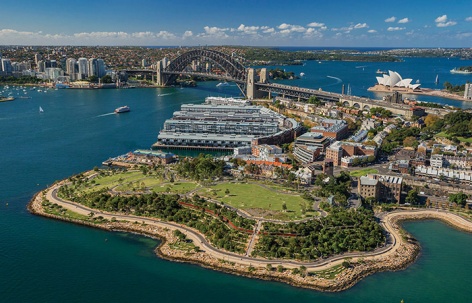
“Barangaroo保护区项目以令人惊叹的方式复兴了悉尼港历史悠久的岬角地带,重新建立了该地区与殖民前时期失去已久的联系,同时创造了一个充满活力的、展现自然主义且对环境友好的公民空间,同时造福于陆上的居民和水中生物。岬角的重建方案包括用现场开采的1万块砂岩打造壮观的前滩景观,以一种优雅而戏剧性的方式回溯了对原住民文化具有重要意义的地貌形态,展现了“同一个星球”计划(One Planet Living)所提倡的原则。人行步道、草坪、地下公共空间以及当地树木和灌木的复杂种植方案,共同将退化的工业用地转变为一个具有高度文化敏感性和可持续性的市民空间。”
– 2019年评审委员会“Barangaroo Reserve is a stunning revival of Sydney Harbor’s historic headland that rebuilds a long-lost connection to the pre-colonial past while creating an active, naturalistic, environmentally sensitive civic space, serving both people and animals, on the land and in the water. The design of the headland includes a dramatic foreshore of 10,000 sandstone blocks excavated directly from the site, an elegant and dramatic way of bringing back a landform important to the original Aboriginal culture and a major element in the project’s compliance with One Planet Living principles. Pathways, lawns, an underground public space, and complex plantings of native trees and shrubs, turn what was once a degraded industrial site into model of civic space, cultural sensitivity, and sustainability.”
– 2019 Awards Jury
来自 ASLA 对gooood的分享。
Barangaroo Reserve | PWP Landscape Architecture
项目概述
PROJECT STATEMENT
占地22公顷的Barangaroo滨水区改造项目重新定义了悉尼港,对全球而言也有着重要的意义。Barangaroo的名称来源于悉尼的一位颇有影响力的女性原住民,该项目是悉尼三区总体规划的第一阶段:原本布满集装箱的混凝土港口被改造为一个种植着超过7万5千株本地植物的公园,由此塑造出一个全新的“岬角俱乐部”。设计方案以历史地图和绘画为依据,用从场地中直接开采而来的1万多块砂岩建造出前滩,同时以象征着殖民前期原始海岸线的“1836墙”为界,打造了新的人行道和自行车道。作为“同一个星球”计划(One Planet Living)的项目之一,Barangaroo保护区回收并重新利用了场地中既有的材料资源。新的岬角下方是一个被称为“Cutaway”的、在挖掘砂岩后形成的巨大空隙,可以用作艺术展览和表演场地,或打造未来的原住民文化中心。Barangaroo保护区将巨大而空阔的混凝土场地转变为了一个可供陆地上的居民和水中生物共同利用的空间,为工业用地向现代场所转变提供了切实的案例。
Named for an influential Aboriginal woman of pre-colonial Sydney, Barangaroo is a globally-significant, 22-hectare waterfront renewal project that redefines Sydney Harbor. Barangaroo Reserve was the first phase in a 3-district master plan. The project re-created a “Club Cape” headland by transforming a concrete container port into a park with over 75,000 plantings native to the region. Guided by historical maps and paintings, the design of the headland includes a foreshore of 10,000 sandstone blocks excavated directly from the site. Walking and bicycle pathways separated by the “1836 Wall” symbolically mark the original precolonial shoreline. A “One Planet Living” project, Barangaroo Reserve reused and recycled all existing materials onsite for the headland. Hidden beneath the new headland, the Cutaway is a massive void formed through sandstone excavation to host art exhibits, performances, or a future Aboriginal Cultural Center. Barangaroo Reserve transforms a huge expanse of empty concrete into usable space for both people and animals on land and in water, marking the transformation of an industrial site into a modern reinvention of its more sustainable past.
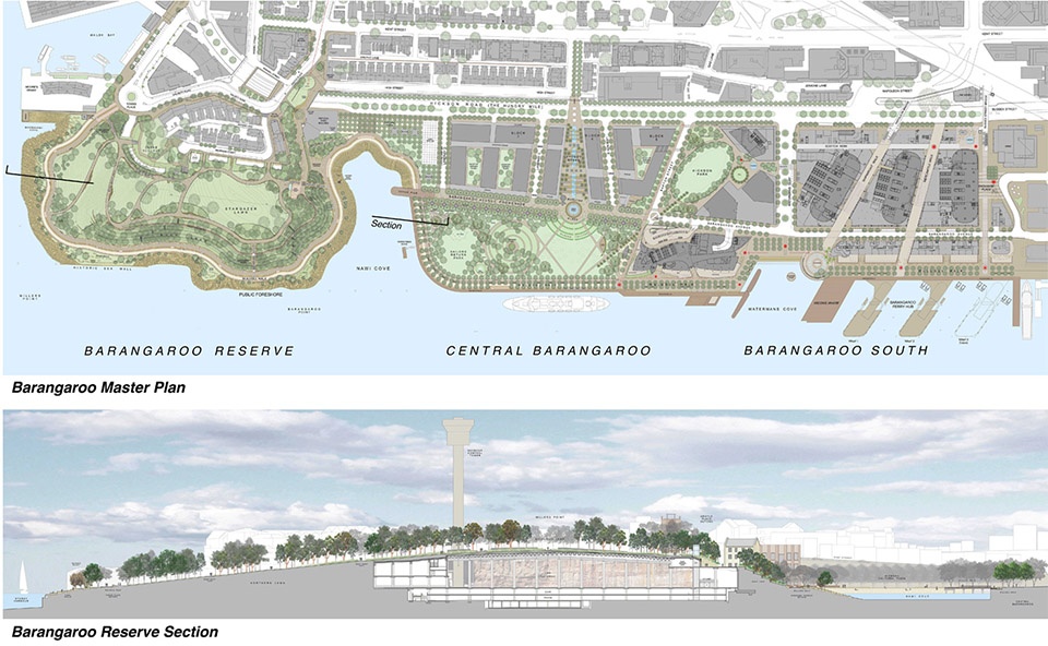
▲悉尼Barangaroo保护区。Barangaroo区域规划平面图和剖面图,后者显示了“Cutaway” 空间和位于地下的双层停车场。Barangaroo Reserve, Sydney. Barangaroo Precinct site plan with section cut through Barangaroo Reserve showing the “Cutaway” and 2-level car park below.
项目说明
PROJECT NARRATIVE
占地22公顷的Barangaroo滨水区改造项目重新定义了悉尼港,对全球而言也有着重要的意义。Barangaroo的名称来源于悉尼的一位颇有影响力的女性原住民,该项目是悉尼三区总体规划的第一阶段:原本布满集装箱的混凝土港口被改造为一个种植着超过7万5千株本地植物的公园,由此塑造出一个全新的“岬角俱乐部”。设计方案以历史地图和绘画为依据,用从场地中直接开采而来的1万多块砂岩建造出前滩,同时以象征着殖民前期原始海岸线的“1836墙”为界,打造了新的人行道和自行车道。
从19世纪中期开始,悉尼港的前滩区域开始被填埋以顺应沿海工业化进程的需要。 Barangaroo地处悉尼中央商务区和岩石区的正西侧,由3个区域构成:占地7.5公顷的南区,主要分布着办公楼和住宅楼;占地5.7公顷的中心区,以多功能开放空间为主;占地6公顷的保护区,坐落着历史悠久的岬角,在该项目中得到了重新改造。Barangaroo保护区完善了悉尼的北部区域,许多著名景点均位于此处,包括皇家植物园、便利朗角和悉尼歌剧院、道斯角以及悉尼海港大桥,此外还修复了欧洲殖民者登陆时Eora Nation原住民所赖以生存的岛屿和海岬。
由景观设计团队提出的设计方案明确了公共空间的主导地位及其与悉尼中央商务区和其它数个相邻历史街区的联系,使原本功能各异的三个区域彼此融合。人行道路线、专用自行车道、新的轮渡码头以及新的地铁站将使这些区域和城市其他地区的交通变得更加便捷。悉尼港的边缘新建了由砂岩和木板构成的Wulugul步道,并设有户外家具和树下荫蔽空间。这条步道将完善总长14公里的悉尼海港步道,形成一条从乌鲁姆鲁到安萨桥的不间断路径,途经皇家植物园、悉尼歌剧院、海港大桥、沃尔什湾、达令港、安萨桥和铁湾大桥等一系列著名景点。
景观团队与来自等各领域的专家(包括当地石匠、土壤科学家、工程师和园艺师)紧密合作,以包括1817年悉尼全景图在内的历史图纸和文献资料为依据,在Barangaroo保护区构建了新的“岬角俱乐部”。首席石匠负责了现场的采石工作,凭借精湛的技艺用1万块从场地中心挖掘的大型砂岩石(这也是构成悉尼港的基础)打造出新的前滩景观。为了实现复杂的设计,团队采用了定制的建模软件和GPS技术,为这一自然主义的建造树立了全球范围的新标准;借助手机应用程序,可以对每一个从古老岩石上切下的石块进行编码和跟踪。在开采以及重建港口和Nawi湾的过程中,从场地中挖走的材料在碾碎后被重新用于地基填补和岬角的塑造。土壤科学家从经过碾压和清洗的石材中开发了土壤混合配方,可以最大程度地促进原生灌木的种植和生长。这些植物均是生长于悉尼本土,早在2年前便在市区以北2小时车程的红树林山(Mangrove Mountain)进行了预先种植。
人行道和自行车道沿着岬角的边缘延伸,并通过象征着殖民前期原始海岸线的矮墙进行分隔。“1836墙”以质朴的石材砌筑,使人联想起悉尼殖民时期的第一座砂岩建筑——类似的材质和饰面在整个城市中随处可见。主人行道从Wulugul步道沿着缓坡向北延伸,最终到达位于岬角顶端的观星草坪(Stargazer Lawn),茂盛的莫顿湾无花果树和桉树为草地带来阴凉。灌木丛掩藏着通往地下空间的电梯,该空间四面以砂岩围合,容纳了300个车位的停车场、Cutaway广场以及一个面积为50mx150m的大型社区活动场地(也是未来的文化中心),使人联想到原住民曾经用作居所的洞穴。
将巨大而空阔的混凝土场地转变为一个可供陆地上的居民和水中生物共同利用的空间,生态性的设计是实现这一目标的关键所在。灌木丛是在公园中建立的最为复杂的生态系统,由3个种植层级构成,包括1)地表植被,如香蕉草和紫哈登柏豆,高度在0.5米至2米之间;2)林下植被,如金合欢、树蕨等,高度在5米内,能够为Barangaroo赋予类似于悉尼岬角的独特形态;3)冠层树木,如体型高大的樟树和桉树等,高度在10米至20米之间,可在灌木层的上方形成具有神圣感的空间。朝向悉尼港的灌木植物选择了更耐晒的品种,区别于南向较为喜阴的温带植物。
为了实现成为全球第一个“气候积极”(climate positive)辖区的目标,Barangaroo的三个区域的规划和设计均遵循了可持续原则。Barangaroo现已被评选为全球17个参与克林顿气候倡议发展计划(Clinton Climate Initiative Development Program)的区域之一,该计划旨在支持将现场二氧化碳排放量降至零的大规模城市项目。Barangaroo项目践行了“同一个星球”计划的可持续原则,具体表现为零碳排放、零浪费、可持续运输、可持续材料、可持续本地食物、可持续用水、可持续土地利用、保护野生动物、促进文化和社区发展、促进公平与地方经济以及改善健康和幸福度等。具体案例如:前滩的建造使用了从场地中开采的约1万块砂岩,使可以装满数千辆卡车的物料无须经过城市交通运至现场;其他的材料也是从本地采购;近1万株本地植物在当地预先种植;前滩区域旨在为鱼类和其他海洋生物提供栖息地;公园本身也直接吸引了大量本地鸟类的迁徙。
恢复象征性的地理环境是重建岬角的目的之一,它使人回想起欧洲人登陆前悉尼古老的原住民时代。在欧洲殖民时期,山羊岛(Goat Island)为Barangaroo和她的丈夫Bennelong所占有,该岛位于呈同心圆分布的原住民区的中央,这些原住民区包括今天的巴拉斯特角、鲍尔斯头、麦克马洪斯角、米勒斯角以及巴尔曼区的最东角。Barangaroo保护区的更新带来了丰富的体育娱乐活动机会,由此也进一步实现了悉尼港前滩管理局在2005年提出的广泛展现土著文化的目标。
Barangaroo保护区结合了对自然进程的重视与文化参照,举例来说,贯穿场地的砂岩与旧时的悉尼有着密不可分的联系,如今被广泛用作建筑材料。另一个例子是由Barangaroo交付管理局执行的公园命名过程,该过程涉及与各方主要利益相关者的密切合作,包括悉尼市政府、大都会地方原住民土地委员会、拉佩鲁斯地方原住民土地委员会、联盛集团以及新南威尔士地名委员会等。Barangaroo的名称反映了原住民的文化、悉尼居民的特质以及该区域的本土历史——这些也是在2006年举办的公共竞赛中最受关注的几个主题。
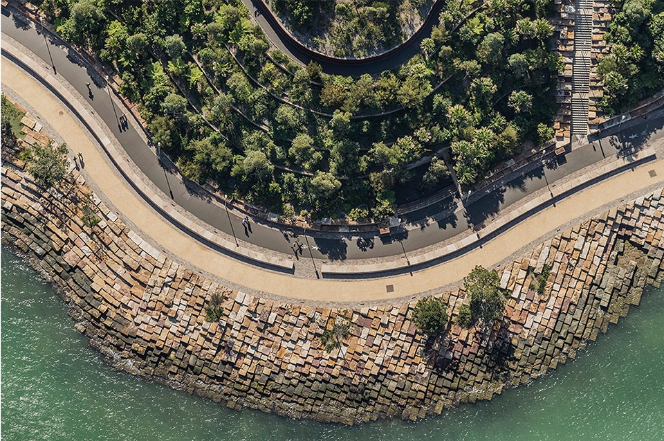
▲悉尼港转向角鸟瞰,地表镶嵌着砂岩块。Barangaroo Reserve, Sydney: Tessellated sandstone blocks placed on Sydney geologic strike angle
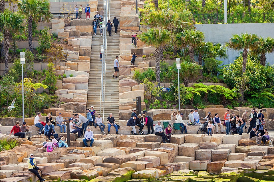
▲布满岩石块的前滩区域,Girra Girra楼梯穿越灌木丛向上延伸。Barangaroo Reserve, Sydney: Foreshore blocks flanking “Girra Girra Steps” up through the bush
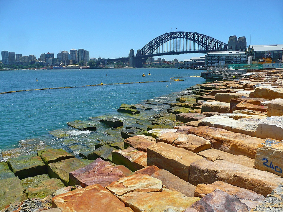
▲Barangaroo保护区位于悉尼港的一个标志性的位置。Barangaroo Reserve, Sydney: Barangaroo Reserve’s iconic location on the Sydney Harbour
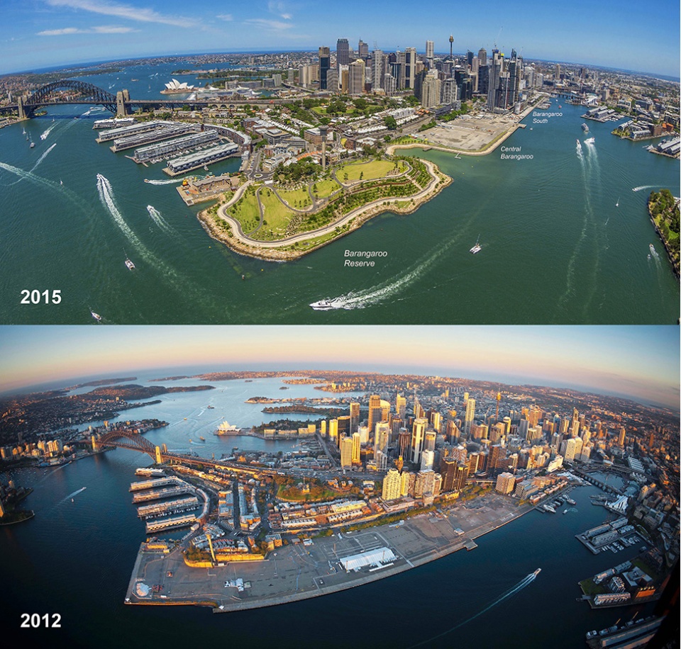
▲Barangaroo保护区重建前后对比。Barangaroo Reserve, Sydney:Before and After photos
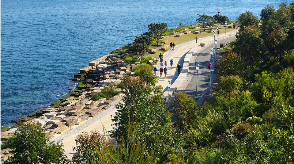
▲前滩公共步道,沿线遍布着本地灌木景观。Barangaroo Reserve, Sydney: Public foreshore promenade with native bush landscape
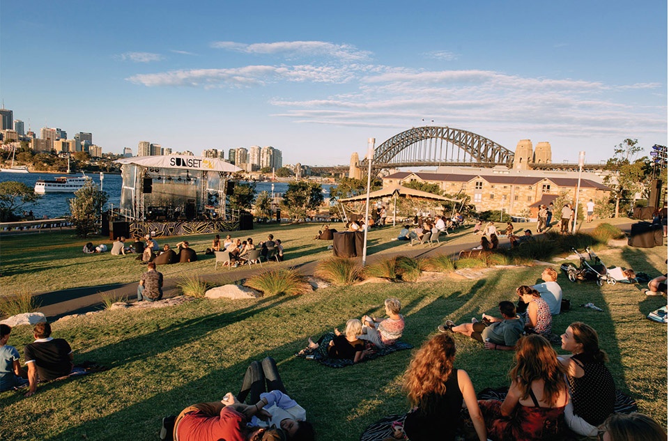
▲休闲与集会空间。Barangaroo Reserve, Sydney: Recreation and gathering
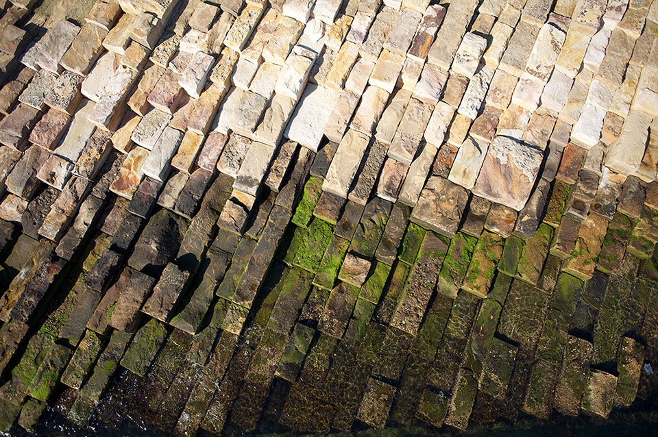
▲砂岩块在海港的铺设方式。Barangaroo Reserve, Sydney: Placement of sandstone blocks in the harbor
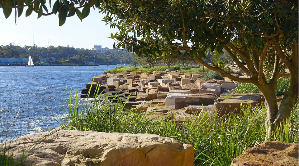
▲重建后的前滩区种植着当地植物。Barangaroo Reserve, Sydney: Native planting at the re-created foreshore
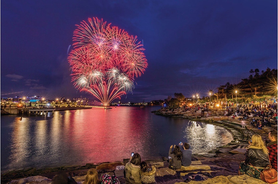
▲海港的壮观美景。Barangaroo Reserve, Sydney: Spectacular views of the harbor
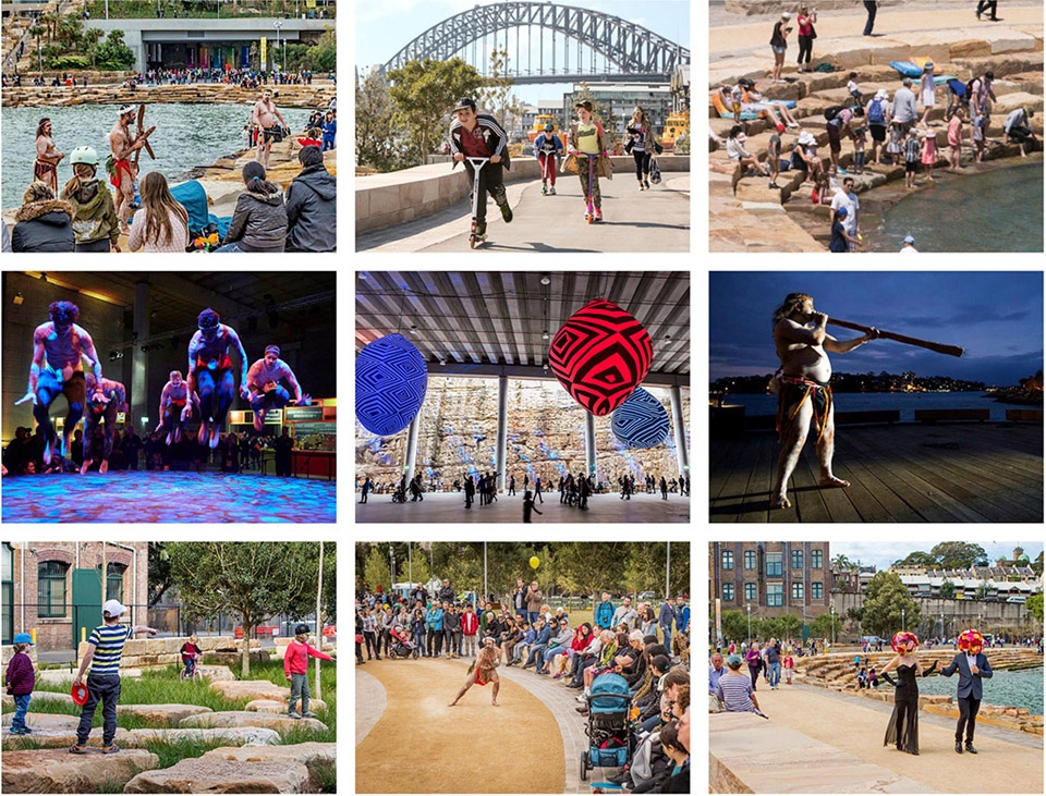
▲功能丰富的活动空间。Barangaroo Reserve, Sydney: Multiple uses and activities
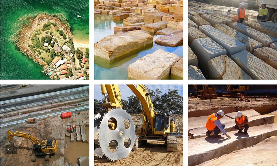
▲从当地采集的砂岩块。Barangaroo Reserve, Sydney: Locally harvested sandstone blocks
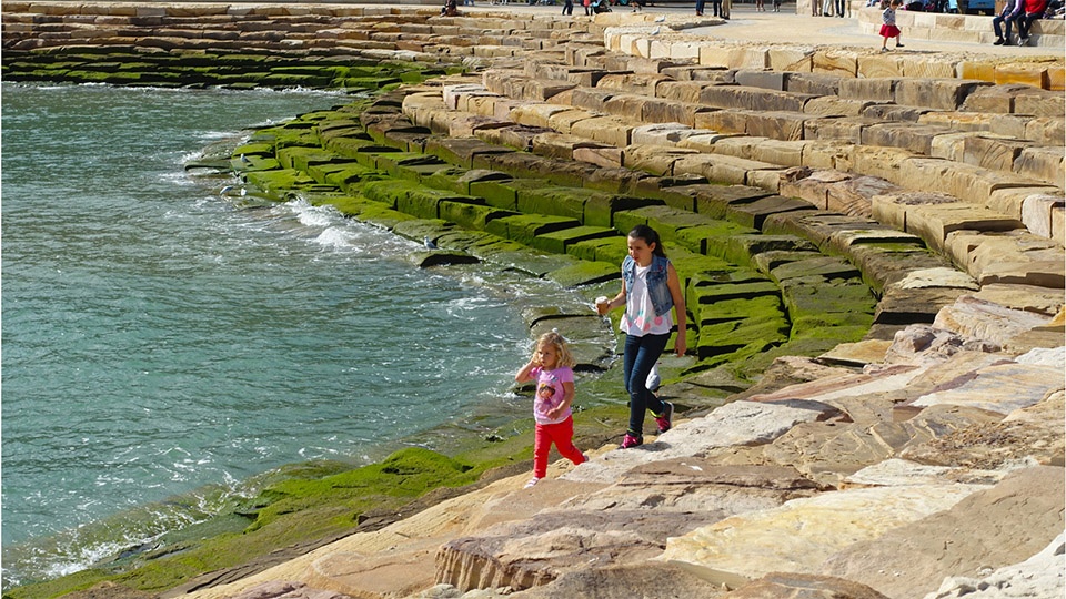
▲在经过近100年的工业活动之后,如今的前滩成为了为公众服务的空间。Barangaroo Reserve, Sydney: After nearly 100 years of industrial activity, the foreshore is now publicly accessible.
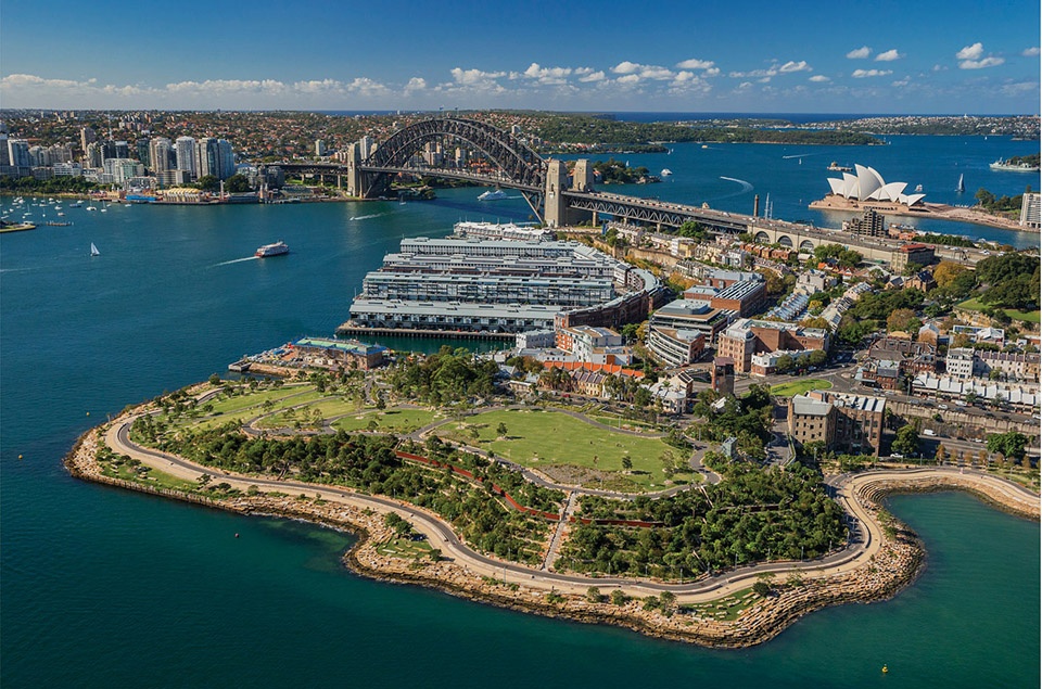
▲Barangaroo保护区鸟瞰。Barangaroo Reserve, Sydney: Aerial view of Barangaroo Reserve
PROJECT NARRATIVE
Named for an influential Aboriginal woman of pre-colonial Sydney, Barangaroo is a globally-significant, 22-hectare waterfront renewal project that redefines Sydney Harbor. Barangaroo Reserve was the first phase in a 3-district waterfront master plan. The project re-created a “Club Cape” headland by transforming a concrete container port into a park with over 75,000 plantings native to the region. Guided by historical maps and paintings, the design of the headland includes a foreshore of 10,000 sandstone blocks excavated directly from the site. Walking and bicycle pathways separated by the “1836 Wall” symbolically mark the original precolonial shoreline.
Beginning in the mid-nineteenth century much of the Sydney Harbour’s foreshore was filled in to create space for maritime industrialization. Lying directly west of the Central Business District and The Rocks (Sydney’s oldest neighborhood), Barangaroo is made up of three areas: Barangaroo South, a 7.5-hectare mix of office and residential development; Barangaroo Central, a 5.7-hectare mixed-use/open space; and Barangaroo Reserve, a 6-hectare re-creation of a historic headland. Barangaroo Reserve completes the northern face of Sydney, a stunning landscape of points including the Royal Botanic Gardens, Bennelong Point and the Sydney Opera House, Dawes Point and the Sydney Harbour Bridge. Barangaroo also restores the visual and symbolic geography of the islands and headlands that were home to the indigenous people of the Eora Nation at the time of European arrival.
Design guidelines completed by the landscape architect define the vocabulary for the public domain and its connections to Sydney’s CBD and several adjacent historic neighborhoods. This shared vocabulary serves to unite three areas with very different programs. Pedestrian routes, dedicated bicycle paths, a new ferry terminal, and a new metro station will increase accessibility between the areas and to other parts of the city. At the edge of Sydney Harbour, Wulugul Walk—developed with a unified vocabulary of sandstone, timber boardwalks, site furniture, and tree canopies—will complete the 14-kilometer Sydney Harbour Walk, an uninterrupted path from Woolloomooloo to the Anzac Bridge passing by landmarks such as the Botanic Garden, the Opera House, the Harbour Bridge, Walsh Bay, Darling Harbour, and the ANZAC and Iron Cove bridges.
At Barangaroo Reserve a “Club Cape” headland was conceived and realized through close collaboration of specialists working with the lead designers, including a local stone mason, soils scientist, engineer, and horticulturalist, each cherished in his field. The design team was guided by geomorphologic studies as well as historical maps and early depictions including Major Taylor’s 1817 panoramic views of Sydney. The chief stone mason was in charge of an on-site quarry operation, creating the foreshore with the artful installation of 10,000 large sandstone blocks—the foundation of Sydney Harbour—excavated from the middle of the site. The complicated design required a customized software modeling program and GPS technology, setting a new global benchmark for naturalistic construction; cut from the ancient rock, each block was barcoded and tracked using a smartphone application. The materials removed from the existing site during the quarry operations and the reshaping of the container port and Nawi Cove were ground up for base-fill layers and creation of the headland. The soils scientist developed a blended soil recipe from the crushed and washed stone waste that maximized the growth of a native bush planting scheme. The plantings are native, not just to Australia but specifically to the Sydney area. Plant material was pre-grown for 2 years on Mangrove Mountain, two hours north of Sydney.
Pedestrian and bicycle pathways wind along the headland, separated by a low, sandstone wall that is a symbolic marker of the original pre-colonial shoreline. The rusticated stone masonry of the “1836 Wall” evokes the first colonial sandstone constructions of Sydney – a material and finish that is ubiquitous throughout the city. An accessible main walkway moves gently up the north slope from Wulugul Walk, terminating at the Stargazer Lawn, the highest point of the headland, which is shaded by large Morton Bay fig trees and eucalyptus. Bush planting discretely conceals the elevator that serves the underground spaces created by the excavation of the sandstone blocks: a 300-car garage and the Cutaway, a large community room—50 by 150 meters—that recalls indigenous cave dwellings and serves as an event space and future cultural center.
Ecological methods were key in restoring this huge expanse of empty concrete into humane, naturalistic, usable space for both people and animals, on land and in the water. The most complex ecological system established as part of the park is the bush, which consists of three planting layers: 1) a ground-plane of plants such as Lomandra and Hardenbergia violacea, which are .5m-2m tall; 2) an understory of plants such as Acacia longifolia, and tree ferns that are up to 5m tall and give Barangaroo the distinctive shape of existing Sydney headlands; and 3) a canopy of trees such as Angophora costata, Eucalyptus pilularis, and Eucalyptus saligna, that are 10m-20m tall and create cathedral-like spaces above the bush planting layers. The plant palette in the bush facing Sydney Harbour receives greater sun exposure and differs from the more shaded and temperate portions facing south.
In order to achieve the goal of becoming the first climate positive precinct of its size in the world, all three districts of Barangaroo have followed sustainable principles in the planning and design process. Barangaroo has been selected as one of 17 developments worldwide to participate in the Clinton Climate Initiative Development Program, which supports large-scale urban projects that reduce on-site CO2 emissions to zero. The project exemplifies the ten One Planet Living principles that provide guidelines for sustainable development: Zero Carbon, Zero Waste, Sustainable Transport, Sustainable Materials, Local and Sustainable Foods, Sustainable Water, Land Use and Wildlife, Cultural and Community, Equity and Local Economy, and Health and Happiness. For example, the 10,000 blocks of sandstone that make up the foreshore edge were excavated from the site, thereby eliminating the transport of thousands of truck-loads of materials through the city. Other materials were locally sourced, and nearly 10,000 native plants were pre-grown locally. The foreshore was designed to create habitat for fish and other marine life and the park has been an immediate attractor for several native bird species.
One purpose for reconstructing the headland was to reestablish the symbolic geography that reminds us of Sydney’s long pre-European indigenous past. At the time of European settlement Goat Island was occupied and owned by Barangaroo and her husband, Bennelong. The island lay at the center of a concentric ring of other Aboriginal locales including what is now called Ballast Point, Balls Head, McMahons Point, Millers Point, and the eastern tip of Balmain. The physical re-creation offered by Barangaroo Reserve fulfills a goal adopted in 2005 by the Sydney Harbour Foreshore Authority as part of a larger plan to showcase Aboriginal culture.
Barangaroo Reserve unites its concern for natural processes with cultural references. For example, the sandstone abundant in the project makes a historical reference to old Sydney, which developed on top of the stone and used it extensively as building material. Another example is the naming process for the park that was conducted by the Barangaroo Delivery Authority, working closely with key stakeholders including the City of Sydney, the Metropolitan Local Aboriginal Land Council, the La Perouse Local Aboriginal Land Council, Lend Lease, and the New South Wales Geographical Names Board. Names reflect Aboriginal culture, prominent Sydneysiders, and the history of the local area, themes that were also popular in the 2006 public competition that produced the name “Barangaroo.”





这大石头看着很有安全感
这个项目牛逼呀
swa 创始人 彼得沃克作品
真棒
剩下的交给时间来塑造