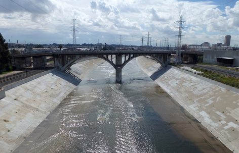
“该项目的可喜之处是其在定性和定量研究间的轻松转换。”
-2017年评审委员会
“What I liked about this project was the ease with which it toggled between qualitative and quantitative procedures.”
– 2017 Awards Jury
来自 ASLA 对gooood的分享。
Abstracting Morphology by 606 Studio Cal Poly Pomona,更多请至:606 Studio Cal Poly Pomona on gooood
Appreciation towards 606 Studio Cal Poly Pomona for providing the following description:
项目陈述
PROJECT STATEMENT
洛杉矶的众多街道阻断了一个相互连接的支流系统,使雨水难以被过滤并输送至该地区的主干河流——洛杉矶河。主干河流雨水系统绿色通道(GRASS)研究项目试图通过自然和人工通道来恢复支流向主干河流的汇入。它建立了一个动态的规划流程,将“自上而下”的政策指令与“自下而上”的解决方案联系起来。各方合作商、学者以及当地专家共同组成了多个工作小组(专家研讨会议),旨在恢复遍布整个城市的街道路面的自然功能。研究的最终结果与地理信息系统(GIS)在迭代循环中实现了整合,最终使GRASS系统得到改进和增强。
研究结果将地理学供水、使用数据及针对当地的特定数据与场地特征及设计创新进行了结合。固定的运输设施、开放空间和交叉路口共同提供了物理节点,带来更多蓄水的机会,同时强调了区域的公平性:与再水化(re-hydrated)相关的项目往往能够使社区变得宜居且富有活力。
Los Angeles’ streets interrupted an interconnected tributary system that collected and delivered filtered water to the regional mainstem: the LA River. The GRASS analysis began as an attempt to restore some of the benefits of the natural tributary system of built and natural corridors. It builds a dynamic planning process that connects “top down” policy directives with “bottom up” solutions. Agency collaborators, academics and local professionals formed multiple working groups or “charrettes” that aimed to restore natural functions to the paved street corridors that traverse the city. The insights that resulted were integrated with GIS in iterative cycles to refine and enhance the GRASS system and tools.
The result connects geographic water supply and use data and local project-specific data with site-specific characteristics and opportunities for design innovation. Fixed transit elements, open spaces, and intersections offer physical nodes that are storage opportunities and part of a regional system that can address equity as re-hydrated projects provide more livable and viable communities.
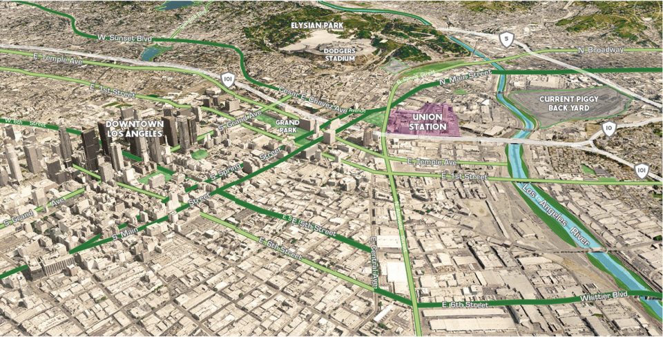
▲项目位置示意,project location
项目说明
PROJECT NARRATIVE
研究问题
大洛杉矶地区的水质已受到来自洛杉矶县内超过44个城市的径流污染。由于目前的工程防洪措施汇聚了大多数不可渗透区域的水流,阻碍了水源的天然自净过程,最终导致径流的水质受损。与此同时,日益渠道化的洛杉矶河、巴洛纳湾以及多明格斯海峡包围了冲击平原,使水质问题变得更加严重(Gumprecht 1999)。
虽然渠道化能够有效限制洪流,却加大了当地河道在暴雨期间的水流速度(USACE 2007)。与每秒输送3万立方英尺水量的科罗拉多河相比,铺砌面积为80%的洛杉矶河的运水量可以达到14万6千立方英尺每秒(Curtiss 1995)。
城市排水系统中复杂的混凝土管道网能够起到管理雨水的作用,以减轻与洪水有关的不利风险,但它同时浪费了原本能够供干旱地区使用的宝贵的潜在水资源(Brown 2005)。在暴雨期间,大量含有垃圾、碳氢化合物以及病原体的污水径流严重破坏了当地海洋以及河岸栖息地的生态完整性。由于违反了联邦政府“清洁水法”(CWA)中规定的负荷总量规定,洛杉矶市最终遭到了罚款(Craig 2005)。
GRASS II项目的目标是开发一种工具,使设计师和工程师能够对大洛杉矶地区的雨水排放和流域规模进行更加完善的管理,从而尽可能地发挥该地区的社会、经济和环境效益。在此目标下,项目还致力于降低城市对于进口水的依赖,同时通过处理径流以减少植被与河岸栖息地的污染负荷。南加州可持续供水系统的有效性最终将决定专家提出的绿色基础设施(GI)、气候变化、调节运输系统以及雨水处理项目能否得到实施。
方法
GRASS I项目利用地理信息系统(GIS)来确定现有街道的分类,包括走道、自行车道、公交车道和既有的水渠等。GRASS I根据最新的数据和建模方法制定了细致的地理设计解决方案,能够识别出理想的、资源丰富且具有连接性的“支流”路径,使其服务于多个社区和建筑。以纯粹的GIS为基础,GRASS I为洛杉矶基础设施的定量分析提供了一种严谨且无偏差的技术方法。
不过,GRASS I的技术方法未能对人性化的优先次序、政治机会以及综合决策等实际情况进行有效的整合。GRASS II就此诞生。借助设计专家的专业知识以及基于地理信息系统的建模和地面实验,GRASS II提供了一种迭代式的研究和分析方法。收集自专业人士的生物物理和社会文化数据为地理信息系统模型的创建提供了信息资料。随着当地从业者的实践和再设计,该系统模型将日趋完善。研究和分析过程最终以实地调查收尾,以进行查漏补缺。评估的标准包括0.5英里长的调整缓冲区、路径通达性、公众影响度以及绿色基础设施适应性等几部分内容。整个过程最终形成了由四条基础雨水绿色通道(SWG)构成的系统,以一套次级雨水绿色网络。
结果
GRASS雨水绿色通道的长度为184.5英里,不及洛杉矶水道的一半。该通道由多个相互连接的部分组成,能够通过自然的程序来完成雨水的捕获、过滤和渗透。除了能够管理雨水供人使用,绿色通道还能将高度城市化的社区和服务水平低下的社区通过自然环境进行连接,从而实现地区界线的重塑。
四条基础雨水绿色通道起始于洛杉矶河上游丘陵的高生态价值地区,确切的源头分别位于卡特岩屑盆地(Carter Debris Basin)、伊顿峡谷自然区(Eaton Canyon Natural Area)、汉森水坝游乐场及骑马中心(Hansen Dam Recreation Area and Equestrian Center)以及布朗溪流公园(Brown’s Creek Park);终点分别位于巴罗纳湿地(Ballona Wetlands)、雷东多海滩港口(Redondo Beach Harbor)、洛杉矶港(Los Angeles Harbor)以及太平洋水族馆(Aquarium of the Pacific)。相比位于人口稠密的城市化地区的终点,绿色通道的起点主要位于具有高度生态价值和休闲价值的自然区域,这种选择主要以该地对于公众的潜在教育价值及其可见度和知名度为依据。
这些通道穿越了公园匮乏的不发达地区,通过连接并扩展既有的自行车、轻轨和地铁线路,使关键性的机会区域和公共开放空间相互贯通,并将雨水设施连接为一个综合的系统,最终促成了整体性的多模式联运。
场地设计与落实
绿色通道在水质方面的挑战之一是,虽然渗透性雨水的数量和质量能够通过透水面和植被条件的改善而改善,但洛杉矶的干旱状况需要将灌溉区域和草坪进行移除,这已然对土壤和城市绿荫形成了冲击。
GRASS项目为雨水的捕获、重新利用、循环使用以及更繁密的绿荫描绘了一幅蓝图,同时还将继续减少和限制城市的用水量。该方法能够促进植被的增加,尤其是在绿色通道经过的区域,并以此改善公园匮乏的状况,提供更多绿化区域以及可供野生动物栖息的区域。
GRASS II更采用了具有优先次序的实施方法,在使用者多为儿童、老年人或其他特殊人群的地区,植被的质量和覆盖密度会有相应的提高。这一标准也适用于高度使用区域、商业或旅游区域以及重要街道干线的十字路口或节点区域。
影响
与每秒输送3万立方英尺水量的科罗拉多河相比,该项目的基础雨水绿色通道每年将至少为基础网络捕获1万3千英亩英尺的水量,并能够为叠加的一级和二级网络每年提供至少5万9千英亩英尺的水量(相当于科罗拉多河年径流量的千分之一)。
项目还通过影响分析对基础雨水绿色通道的性能进行了评估。在基础雨水绿色通道经过的地带,预计将有298英亩的硬性景观被替换为植被,而被树荫覆盖的景观面积将增加一倍。以人均享有3英亩的公园面积为目标,该区域最终将为10万人提供服务。GRASS系统使135万人的生活环境形成了连接,并为居住在公园匮乏区域的85万人口提供了优质的公园通道。该方案还将连接洛杉矶联合学区内的285所学校以及98座公园,以促进校园运输、体育活动以及多种交通工具的使用。
结论
GRASS报告将被用于即将进行的总体规划修正案中,以确定下一代洛杉矶居民的基础设施建设以及资金来源。
GRASS提供了一种非常有用的设计工具和方法,可以更加有效地对城市景观中的雨水进行管理。它为本地化的监管改革和政策调整提供了实用的备选方案,同时还带来了独特且有影响力的场地设计,实现了具有策略性的、层级分明的安置和实施计划。
GRASS雨水绿色通道的长度为184.5英里,不及洛杉矶水道的一半。该通道由多个相互连接的部分组成,能够通过自然的程序来完成雨水的捕获、过滤和渗透。除了能够管理雨水供人使用,绿色通道还能将高度城市化的社区和服务水平低下的社区通过自然环境进行连接,从而实现地区界线的重塑。
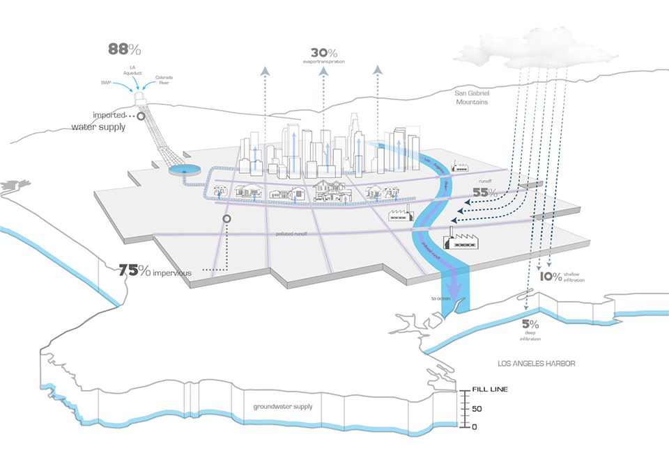
▲洛杉矶水系统的88%依赖于进口水源。Los Angeles’ water system depends on 88% imported water.
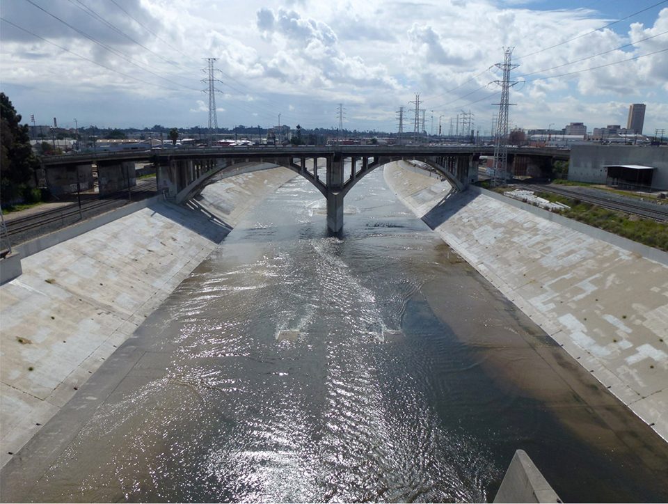
▲南加州可持续供水系统的有效性最终将决定专家提出的一系列项目能否得到实施。The availability of a sustainable water supply in Southern California will determine the viability of projects proposed by design professionals.
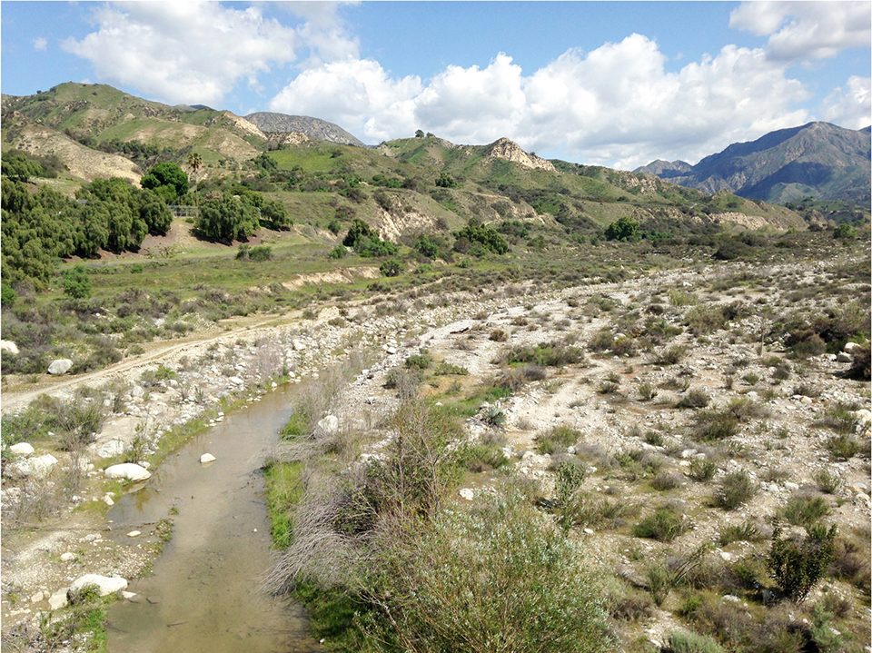
▲GRASS为设计者提供了更加完善的雨水管理工具,同时能够带来显著的社会、经济和环境效益。GRASS is a tool developed to help designers better manage stormwater at a watershed scale in a way that also maximizes social, economic, and environmental benefits.
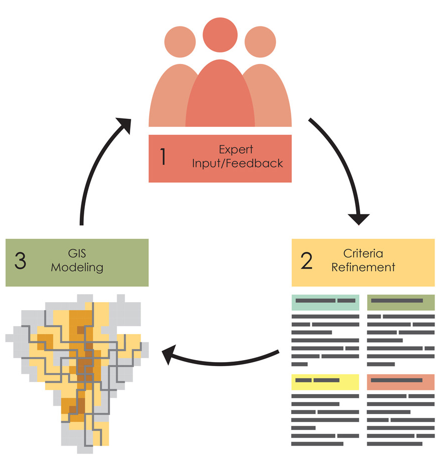
▲借助设计专家的专业知识以及基于地理信息系统的建模和地面实验,GRASS II提供了一种迭代式的研究和分析方法。GRASS employed an iterative approach using charrettes with design professionals. GIS-based modeling and ground-truthing.
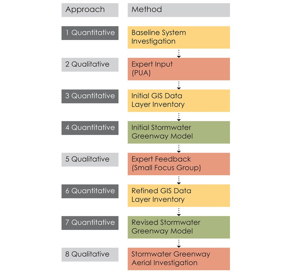
▲迭代式的研究方法在定性和定量的分析之间不断循环。The iterative approach cycled through qualitative insights and quantitative analysis.
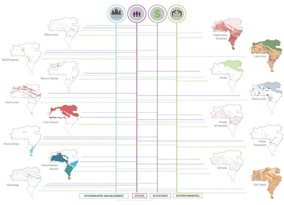
▲在计算机的评估基础上,各方设计者和专家对社会、经济和环境等要素进行了更加人性化的评价。The design professionals and other experts introduced human judgment to the computer-based assessment of social, economic and environmental factors.
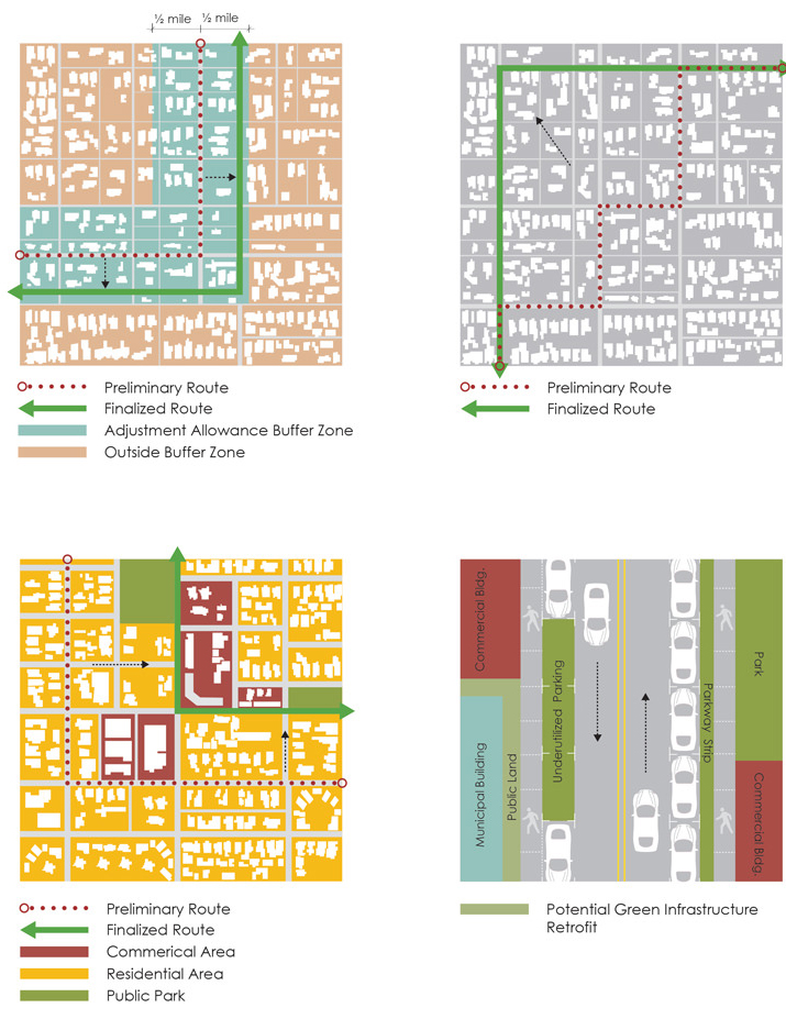
▲研究和分析过程最终以航拍等具体的实地调查收尾,以进行查漏补缺。评估的标准包括0.5英里长的调整缓冲区、路径通达性、公众影响度以及绿色基础设施适应性等几部分内容。The Stormwater Greenways were reviewed in detail using aerial photography and field research to identify missed opportunities. Evaluation criteria included performance improvement within a ½ mill adjustment buffer, public impact, route directness, and areas with high suitability for green infrastructure.
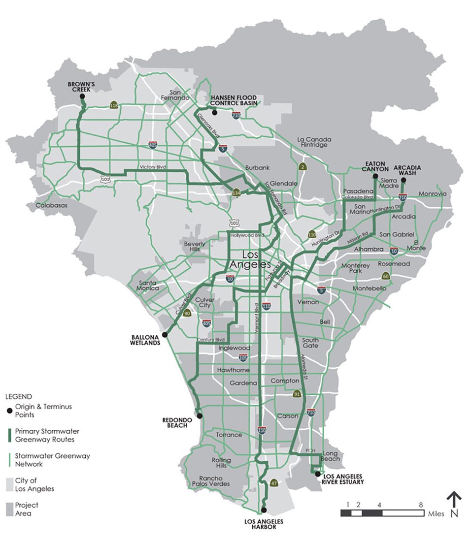
▲GRASS雨水绿色通道的长度为184.5英里,由多个相互连接的部分组成,能够通过自然的程序来完成雨水的捕获、过滤和渗透。The GRASS Stormwater Greenways comprise 184.5 miles of contiguous and interconnected BMPs that capture, filter, and infiltrate stormwater through natural processes.
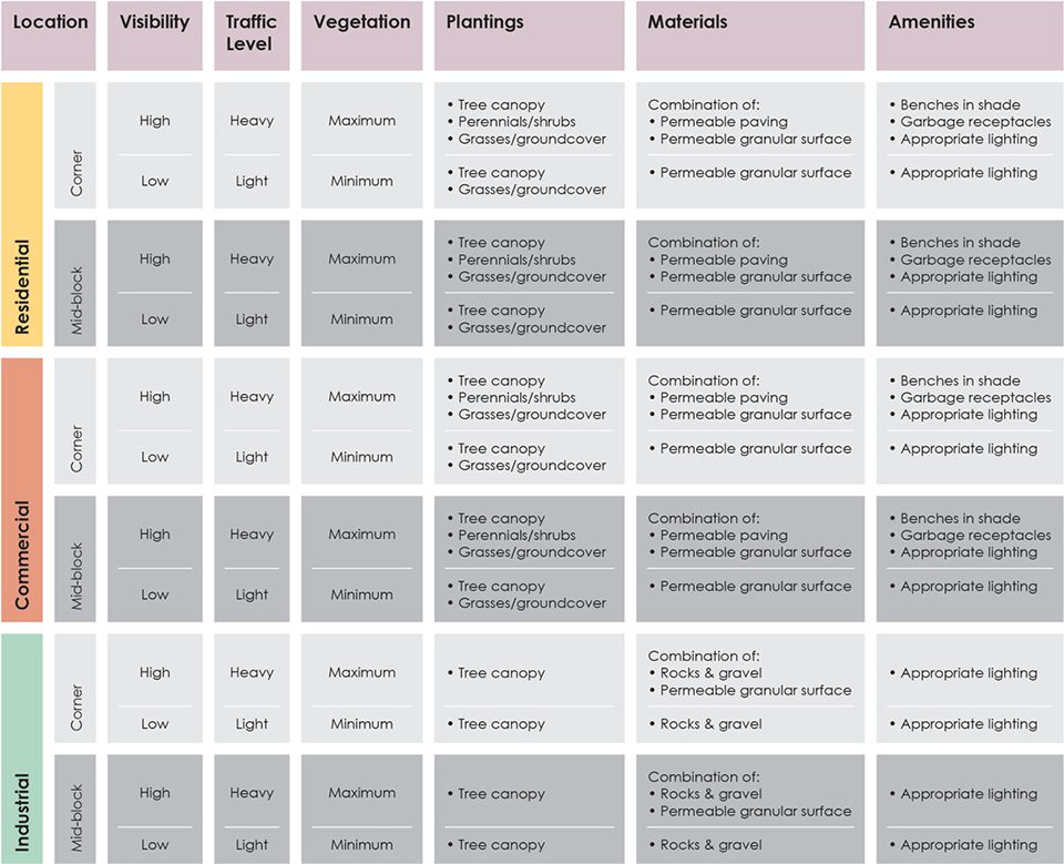
▲GRASS 更采用了具有优先次序的实施方法,GRASS assumes a hierarchy of implementation approaches.
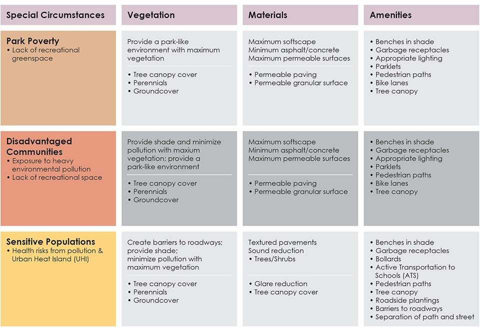
▲在使用者多为儿童、老年人或其他特殊人群的地区,植被的质量和覆盖密度会有相应的提高。Where SWGs will be used by large numbers of children, seniors, or other special populations, a higher standard of vegetative density and cover is proposed.
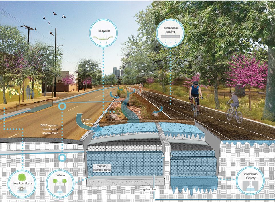
▲该项目开发的设计工具箱能够将规划原则转化为具体的设计。A design toolbox was developed to assist in translating planning principles to design.
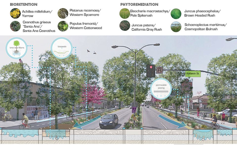
▲该项目开发的设计工具箱能够将规划原则转化为具体的设计。A design toolbox was developed to assist in translating planning principles to design.
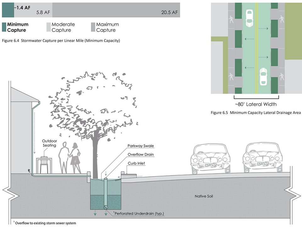
▲捕水场景的模拟阐明了各种干预措施带来的影响和预计水量。Capture scenarios were modeled to illustrate the impact of various levels of intervention and estimate water volumes.
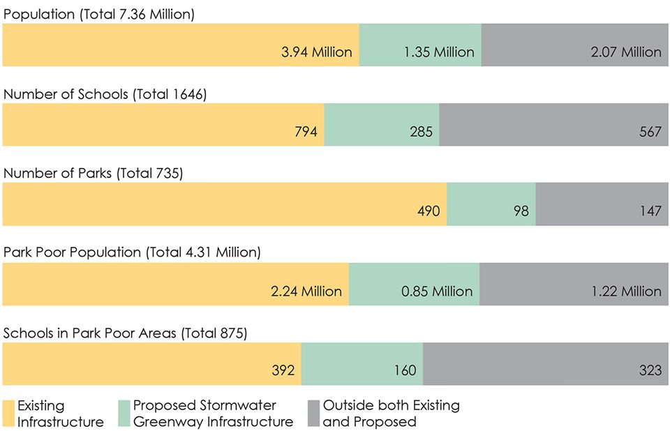
▲从社会文化影响的模拟数据可以看出居民数量的增加,以及拥有优质绿色空间的学校和公园的数量。Socio-cultural impacts were modeled to illustrate the increased number of residents and the number of schools and parks with improved access to green space.
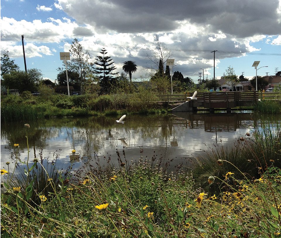
▲GRASS的184.5英里的雨水绿色通道由多个相互连接的部分组成,能够通过自然的程序来完成雨水的捕获、过滤和渗透。除了能够管理雨水供人使用,绿色通道还能将高度城市化的社区和服务水平低下的社区通过自然环境进行连接,从而实现地区界线的重塑。GRASS’s 184.5 miles of contiguous and interconnected BMPs capture, filter, and infiltrate stormwater trhough natural processes. They will also reshape the region’s physical identity by connecting highly urbanized communities with the natural environment.
PROJECT NARRATIVE
RESEARCH PROBLEM
Water quality in the Los Angeles metropolitan area is affected by contaminated urban runoff from over 44 municipalities within Los Angeles County. The quality of runoff is impaired because the current engineered flood control approach concentrates flows from mostly impermeable areas that compromise the natural processes that filter and infiltrate polluted water. Exacerbating this problem, flood plain benefits are circumvented by the predominantly channelized Los Angeles River, Ballona Creek, and Dominguez Channel (Gumprecht 1999).
While effective at limiting flooding, the channelization of the region’s waterways substantially increases the velocity of flows during storm events (USACE 2007). In comparison with the Colorado River, which transports 30,000 cubic feet of water every second, the 80% paved Los Angeles River has the capacity to move 146,000 cubic feet of water per second (Curtiss 1995).
The complex network of urban drainage concrete conduits, which primarily manage stormwater to alleviate the adverse risks associated with flooding, wastes a potentially valuable water resource in a location plagued by drought (Brown 2005). During storm events, higher volumes of discharged polluted runoff containing trash, hydrocarbons, and pathogens severely diminish the ecological integrity of marine and estuarine riparian habitats in the region. This results in fines for the City of Los Angeles due to violations of TMDLs mandated by the federal Clean Water Act (CWA) (Craig 2005).
The project goal of GRASS II was to develop a tool to help designers and engineers to better manage stormwater from the watershed scale within the Los Angeles metropolitan area to the site scale to maximize social, economic, and environmental benefits for the region. Within that goal, objectives needed to be met with parallel challenges to limit the city’s dependence on imported water. The GRASS program also needed to treat runoff to minimize the loading of pollutants in vegetated and riparian habitats.
The availability of a sustainable water supply in Southern California will ultimately determine the viability of proposed green infrastructure (GI), climate change, and coordinated transportation/stormwater projects by design professionals.
METHOD
GRASS I used GIS to identify existing street classifications with wide corridors, bike routes, bus routes, and existing storm drains. GRASS I produced an elegant geo-designed solution based on the most current data and a modeling approach developed to identify ideal SWGs as resource-rich and connective “tributary” locations that could serve multiple communities and projects. It offered both rigor and an unbiased technical approach based on a purely GIS-based quantitative analysis of Los Angeles’ infrastructure.
The technical approach of GRASS I failed to integrate the realities of human priorities, political opportunities, and integrative decision making. GRASS II was born. Its research and analysis employed an iterative approach using insights from design professionals, GIS-based modeling, and ground-truthing. Biophysical and socio-cultural data layers gathered as a result of expert input served to inform the creation of a GIS model that was refined and finalized through subsequent rounds design by local practitioners. The research and analysis process concluded with a ground-truthing investigation and field research to identify missed opportunities. Evaluation criteria included performance improvement within a ½ mile adjustment buffer, route directness, public impact and areas with high suitability for green infrastructure.
This process resulted in the generation of four Primary Stormwater Greenways (SWGs) and a Secondary Stormwater Green Network.
RESULTS
Less than half the length of the Los Angeles Aqueduct, the GRASS Stormwater Greenways are a combined 184.5 miles of contiguous and interconnected BMPs that capture, filter, and infiltrate stormwater through natural processes. Besides managing stormwater for human use, the Stormwater Greenways reshape the region’s physical identity by connecting highly urbanized and under-served communities with the natural environment.
The four SWGs originate in the foothills of the Upper LA River Watershed in areas characterized by high ecological value. The specific origins include the Carter Debris Basin, Eaton Canyon Natural Area, the Hansen Dam Recreation Area and Equestrian Center, and Brown’s Creek Park. The terminus points include the Ballona Wetlands, Redondo Beach Harbor, Los Angeles Harbor, and the Aquarium of the Pacific. Unlike the terminus points that are located in densely-populated urbanized areas, the stormwater greenway origins are primarily located in naturalistic areas that have high ecological and recreational value. These points were primarily selected based on their potential educational value to the public and high visibility and exposure.
They traverse disadvantaged areas of high park poverty, encourage comprehensive multi-modal transit by linking and extending existing bike routes, light rail, and subway lines, connect key opportunity areas and public open space, and connect stormwater projects into one integrative system.
SITE DESIGN AND IMPLEMENTATION
One of the challenges of the green infrastructure approach to water quality is that while the quantity and quality of infiltrated stormwater are improved with pervious surfaces and vegetation, the drought in Los Angeles has called for the removal of irrigation and turf grass areas, which has impacted soils and the urban tree canopy.
GRASS offers a blueprint for supporting re-use of captured storm water, recycled water, and greater tree canopy while continuing to reduce or manage water consumption. This approach supports increased vegetation, especially in areas where the Stormwater Greenways are intended to ameliorate park poverty or provide urban greening or wildlife habitat functions.
As such, GRASS II assumes a hierarchy of implementation approaches. Where SWGs will be used by large numbers of children, seniors, or other special populations, a higher standard of vegetative density and cover is proposed. This standard is also applied in high use areas, in commercial or tourist areas, in park poor areas, and at the intersections or “nodes” formed by significant street arterials.
IMPACTS
In comparison with the Colorado River, which transports 30,000 cubic feet of water every second, the completed SWG system proposed by this project would capture a minimum of 13,000 acre feet per year (AFY) for the primary network, and a minimum of 59,000 AFY for the combined primary and secondary networks (1/1000 of the annual volume of the Colorado River).
The impact analysis was executed to assess the performance of the SWG system. Along the Primary SWGs, an estimated 298 acres of existing hardscape will be replaced by vegetation, while the acreage of hardscape currently shaded by tree canopy cover will double. At the target of three acres park-space per thousand residents, this area would serve 100,000 people. The GRASS system connects 1.35 million people to trails, and improves park access for 850,000 people living in park poverty conditions. The proposal also connects 285 Los Angeles Unified School District schools and 98 parks to the trail system, supporting active transportation to school, physical activity and the increased used of alternative modes of transportation.
CONCLUSION
The GRASS report will be used in upcoming amendments to the General Plan, to determine infrastructure priorities and funding for the next generation of Los Angeles residents.
It offers a much needed design tool and approach that can be utilized to manage stormwater in urban landscapes more effectively. It provides pragmatic alternatives that support localized regulatory reform, political coordination and compromise, unique and impactful site designs, and implementation with strategic benchmarking, sequencing, and placement.
Less than half the length of the Los Angeles Aqueduct, the GRASS SWGs comprise 184.5 miles of contiguous and interconnected BMPs that capture, filter, and infiltrate stormwater through natural processes. Besides managing stormwater for human use, the SWGs will reshape the region’s physical identity by connecting highly urbanized communities with the natural environment.
More: ASLA,更多请至:606 Studio Cal Poly Pomona on gooood






在GTA5里学风景园林
GTA V 哈哈哈(滑稽)
在那个河道里逃过警察追捕
我也觉得我看第一眼就想起来了飞机训练
河道,铁轨,桥梁,不远处就是莱斯特的服装厂(HJ)
海绵案例还挺不错的