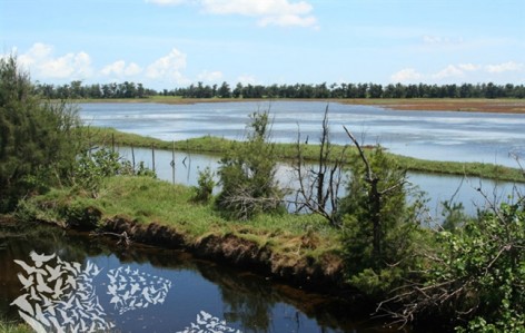
“Among the best water initiatives we saw. It’s interesting that they took the approach that a previously reclaimed shoreline should go back to the natural–what a radical move. The scale was amazing, instead of just looking at the landscape, they looked at global flyways. A really clear presentation that resonates.” —2011 Professional Awards Jury
“在我们所看到的那些优秀的应对水的措施中,这个方案有趣的将填海地区的海岸线回归成自然状态,这是多么激进而彻底的举动。尺度惊人,不仅可以观赏风景,也成为鸟类全球迁徙路程的一部分,这里上演着真正的自然,引起人们的共鸣。”—2011年专业奖评审委员会
By National Sun Yat-sen University, Kaohsiung, Taiwan。更多请至:National Sun Yat-sen University, Kaohsiung on gooood
纪录片《迁徙的鸟》开篇第一句话是:“鸟的迁徙是一个关于承诺的故事。”电影导演也表示“飞翔对鸟来说不是人们想象的什么乐趣,而是为了生存而拼搏。它们要穿越云层、迎着暴风雨,许多困难不是我们能够想象的。”
候鸟是脆弱的,容易受到伤害的,但是候鸟也是极度敏锐的,在这个自然环境日益恶劣的地球,他们总能在第一时间发现适合避难的新天堂。它们的选择和行为,就是大自然最直白的评价。真正的自然,无需人类任何褒奖,获得动物们的认可足以。
———————————–
项目概况:
项目占地1600公顷并位于亚洲鸟类迁徙路线之上。湿地的基础是以前填海的土地。原来的土地不能继续使用是因为该区地表下陷和农耕停止。项目立足于人类发展的可再生居住策略,顺应场地自然系统的演进过程,并发挥其环境教育和生态旅游的意义。
项目内容:
在过去的几十年中,平坦宽敞的题海用地具有各种用途与发展。但其与自然保护之间的争论冲突一直在全球各地上演。这个位于台湾西南部的鳌鼓湿地森林公园,经历了各种阶段的发展最终演变成为自然湿地。1964年以前,这里还是典型的潮汐泥湿地。后来由于农耕和畜牧业的发展到此这个地方建设了C型海塘,占用了超过1,000公顷的湿地。但原本打算用来种植甘蔗、养猪和养鱼的这片地方,在地表下沉和几次洪水之后,土壤盐分变多而不能生产甘蔗。最终在2001年, 这里被用作造林区。过去的四十年中,该地区发生了显著的演变,目前这里有自然湿地也有人工森林的结合。鳌鼓湿地森林公园是在此基础上发展产生。这个森林公园是自然生态系统进程中的演示性区域。恢复成海滨湿地后, 意外的成为了迁徙候鸟和其他野生动物的避难所。该项目以人为本,保护自然,并强调自然系统、环境教育、生态旅游和文化延续的可持续性和关联性。
项目挑战:
季节性洪水和干旱,以及土地沉降。因为C型海棠的封闭,台风季节每月将于在300—500毫米,而干旱地区这里的淡水严重不足。水污染。以前养猪场的规模达到3万头猪,虽然猪场废水经过简单处理,但是养鱼场和其它区域的水污染一直未得到解决。造林项目。因为经济原因,最开始都是单一林区,具备很低的多样化性,同时人工林和自然林的交替过渡也存在问题。因为候鸟数量增多,引发了有人增多,无节制的旅游活动需要被管理。在总规划中希望用最小的影响来解决环境问题以及恢复自然栖息地。概念就是“依返,保护,建立环境和教育价值。”
分析和规划过程:
面临着复杂的水文和自然环境系统:1 确定文化设施;2 识别和保护重要栖息地;3 被淹没的房子保留;4 尊重种植物和自然植物;5处理污水;6为旅游留出区域。
战略
根据环境敏感性制定保护策略。西不是核心保护区。中部是缓冲区,为游客和村民提供旅游和种植服务。东部是环境敏感性低的入口区,承担教育和示范作用。项目力求回复不同栖息地和各种生态系统。湿地,红树林,滩涂,林地,草地,野生场地,钓鱼区等等都被整合到湿地公园。
水文策略
这里淡水稀缺,暴雨季节又泛洪。因此各类湿地被设计成为最大化利用淡水资源。中心公园有0.3万立方米的洪水泄洪池。湿地在净化这里的雨水,可作为农业生产用水,发挥重要作用。
种植策略
盐湿地导致植物生长不好,种类少。通轻微改变地形,增大种植面积,进行引种和补种。1 ,调查多达百种植物;2,创建微地形,补充本土植物达到生物多样性;3,引发自然演替;4,将景观和活动整合。
分区策略
为了保证环境多样性,从东到西,环境保护准则越来越高。西侧拥有最高的生物多样性,享受核心保护。开挖的一些人工渠道成为新兴的多样化生物栖息地。中部公园有300人的小村,村民继续打渔,同时设置排涝泵保护这里不旱不涝。东侧的入口区域靠近著名的寺庙。公园开放了水上区域,允许游客中深度潜入公园,体会自然环境,接受景观环境教育,东部区域也拥有商业和基本服务区域。
实施策略
开发过程中保持了公众的高度参与,各专家帮忙协商。列出最重要的问题,实施淘汰战略。组件可持续性管理框架。组织政府以及非政府部门,保证和维持公园运作。
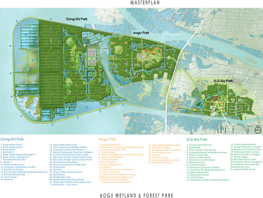
▲总平面
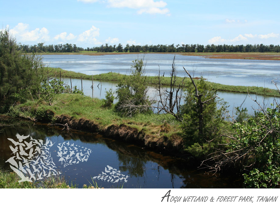
▲公园一景
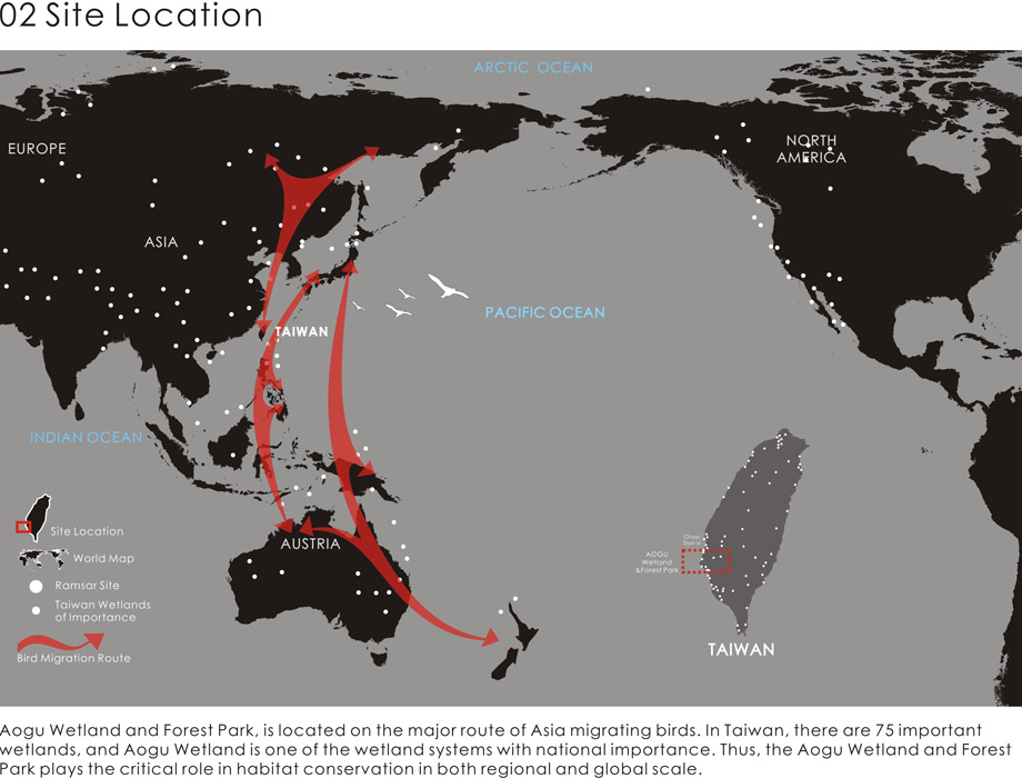
▲场地位置
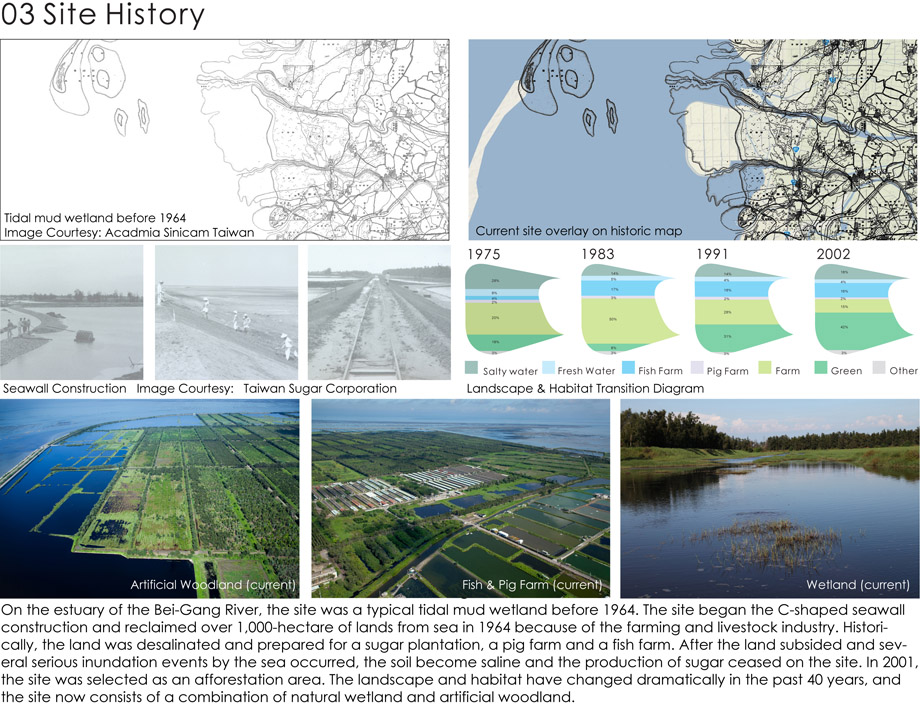
▲场地历史
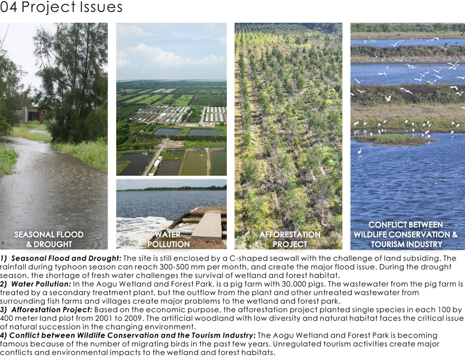
▲项目问题
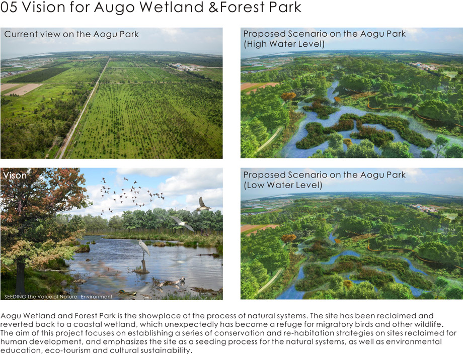
▲未来景观展望
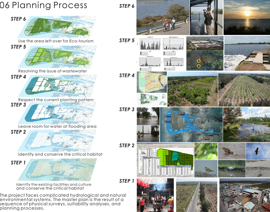
▲项目演进
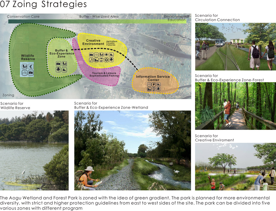
▲分区策略
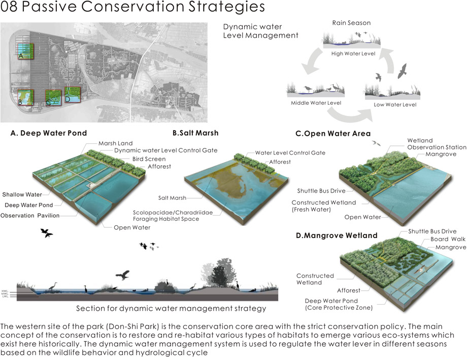
▲被动保护策略
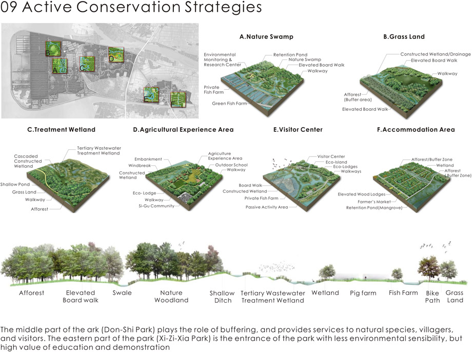
▲积极保护策略
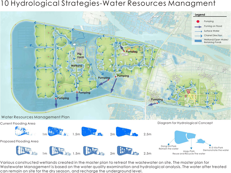
▲水文战略—水资源管理
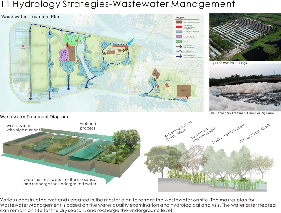
▲水文战略—废水管理
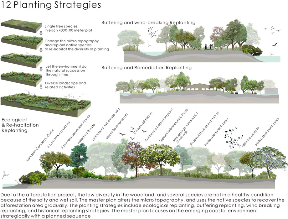
▲种植策略
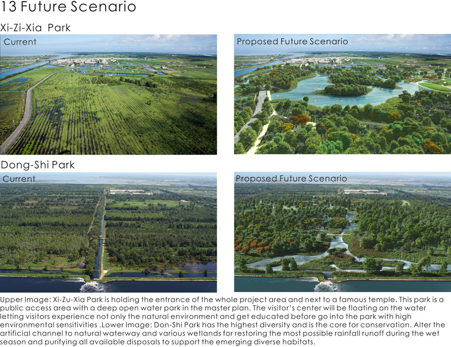
▲未来景愿
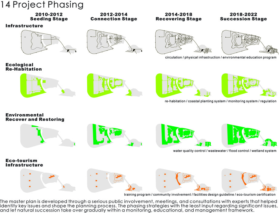
▲项目演进
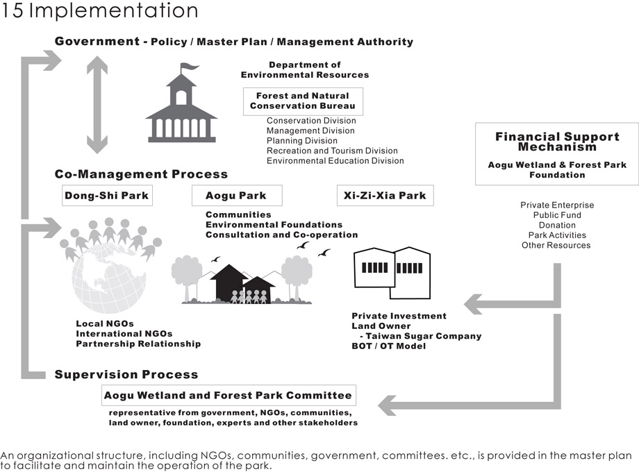
▲实施
An Emerging Natural Paradise — Aogu Wetland Forest Park Master Plan
Project Statement
Aogu is a 1,600-hectare site located on the route of Asian migrating birds. The site has been reclaimed from the sea and unexpectedly reverted to a coastal wetland because of land subsiding and the cessation of farming in the area. The project focuses on establishing a series of re-habitation strategies on site that is reclaimed for human development, and emphasizes the site as a seeding process for the natural systems, as well as environmental education and eco-tourism.
Project Narrative
Over the past decades, flat and spacious coastal areas have been seen various usages and development. The contention and conflict between human development and natural conservation along the coastal area occur all around the world. The project, Aogu Wetland and Forest Park, is located in the southwest area of Taiwan, and has experienced different stages of development before it eventually reverted to natural wetland. On the estuary of the Bei-Gang River, the site was a typical tidal mud wetland before 1964. The site began the C-shaped seawall construction and reclaimed over 1,000-hectare of lands from sea in 1964 because of the farming and livestock industry. Historically, the land was desalinated and prepared for a sugar plantation, a pig farm and a fish farm. After the land subsided and several serious inundation events by the sea occurred, the soil become saline and the production of sugar ceased on the site. In 2001, the site was selected as an afforestation area. The landscape and habitat have changed dramatically in the past 40 years, and the site now consists of a combination of natural wetland and artificial woodland. The Aogu Wetland and Forest Park comes from this changing process of environment.
Aogu Wetland and Forest Park is the showplace of the process of natural systems. The site has been reclaimed and reverted back to a coastal wetland, which unexpectedly has become a refuge for migratory birds and other wildlife. The aim of this project focuses on establishing a series of conservation and re-habitation strategies on sites reclaimed for human development, and emphasizes the site as a seeding process for the natural systems, as well as environmental education, eco- tourism and cultural sustainability.
Project Issues
Seasonal Flood and Drought: The site is still enclosed by a C-shaped seawall with the challenge of land subsiding. The rainfall during typhoon season can reach 300- 500 mm per month, and create the major flood issue. During the drought season, the shortage of fresh water challenges the survival of wetland and forest habitat.
Water Pollution: In the Aogu Wetland and Forest Park, is a pig farm with 30,000 pigs. The wastewater from the pig farm is treated by a secondary treatment plant, but the outflow from the plant and other untreated wastewater from surrounding fish farms and villages create major problems to the wetland and forest park. Afforestation Project: Based on the economic purpose, the afforestation project planted single species in each 100 by 400 meter land plot from 2001 to 2009. The artificial woodland with low diversity and natural habitat faces the critical issue of natural succession in the changing environment.
Conflict between Wildlife Conservation and the Tourism Industry: The Aogu Wetland and Forest Park is becoming famous because of the number of migrating birds in the past few years. Unregulated tourism activities create major conflicts and environmental impacts to the wetland and forest habitats.
The Aogu Wetland and Forest Park master plan aims to use methods with the least impact to resolve the environmental problems and restore the natural habitats for various types of waterfowl and wildlife. The main concept for this project is returning, keeping, and recreating this site to its environmental and educational values.
Analysis and Planning ProcessThe Aogu Wetland and Forest Park faces complicated hydrological and natural environmental systems. The master plan is the result of a sequence of physical surveys, suitability analyses, and planning processes describing the following: 1) identify the existing facilities and culture; 2) identify and conserve the critical habitat; 3) leave room for water at flooding area; 4) respect the planting and natural pattern; 5) resolve the issue of wastewater; and 6) use the area left over for eco-tourism.
Conservational Strategies
The conservation strategies are designed based on environmental sensibility in various areas. The western site of the park (Don-Shi Park) is the conservation core area with strict conservation policies. The middle part of the park (Don-Shi Park) plays the buffering role and provides services to natural species, villagers, and visitors. The eastern part of the park (Xi-Zi-Xia Park) is the entrance of the park with less environmental sensibility, but of high value in regard to education and demonstration. The main concept of the conservation is to restore and re-populate various types of habitats to recreate various eco-systems that existed here historically. In the master plan, marsh, mangrove, mud flat, open water, salt mud, ditches, woodland, grass land, wild farm, fishing ponds, etc., are merged into the wetland and forest park.
Hydrological Strategies
Freshwater is scarce at the site. Therefore, keeping all available fresh water on site has been the guideline for the hydrological strategies, except the storm rainfall intensity is higher than design standard. Since the rain is unevenly distributed over the year, various types of wetlands have been designed for maximizing utilization of the available freshwater sources. A flood-detention pond at the center of the Don-shi Park, which is capable of storing the 0.3 million cubic meters of storm rainfall runoff that comes only once or twice a year. Domestic discharges and farm disposals are collected through drainage ditches, purified through a set of constructed wetlands, and stored in the detention pond during the dry season. This will play the most important role in keeping the proposal green and viable.
Planting Strategies
Due to the afforestation project, the low diversity of the woodlands, and several species are not in a healthy condition because of the salty and wet soil. The master plan alters the micro-topography, and uses the native species to recover the afforestation area gradually. The planting strategies include ecological replanting, buffering replanting, wind-breaking replanting, and historical- replanting strategies. The master plan focuses on the emerging coastal environment strategically with the following sequence: 1) get detailed surveys of the tree species in each 100 by 400 meter land plot; 2) create micro-topography changes and replant native species to re-habitat the diversity of planting; 3) allow the environment return to the natural succession through time; and 4) merge diverse landscape and related activities.
Zoning Strategies
The Aogu Wetland and Forest Park is zoned with the idea of green gradient. The park is planned for more environmental diversity, with strict and higher protection guidelines from east to west sides of the site. The park can be divided into three major parks. From west to east are Don-Shi Park, Don-Shi Park and Xi- Zi-Xia Park sequentially. Don-Shi Park has the highest diversity and is the core for conservation. The plan is to alter the artificial channel to natural waterways and various wetlands for restoring the most possible rainfall runoff during the wet season and purifying all available disposals to support the emerging diverse habitats. Aogu Park has a small village (300 people) in its center. This park acts as a Wise Use Area in the master plan. People living in this area can practice their fishing farm in a sustainable way, and use this area as a center for outdoor education. A ring-wetland system will be connected through created waterways around the village to protect it from flooding and treating the domestic disposals. Water will be circulated within the ring by using the flood drainage pumps to maintain creativities and biodiversity during the dry season. Xi-Zu-Xia Park is holding the entrance of the whole project area and is next to a famous temple. This park is a public access area with a deep open water park in the master plan. The visitor’s center will be floating on the water, letting visitors experience the natural environment and become educated before going into the park with high environmental sensitivities. Basic services and facilities can be provided to the public. Local people can use this area to set up their commercial development and services to the whole project area eventually.
Implemental Strategies
The master plan is developed through a serious public involvement, meetings, and consultations with experts that helped identity key issues and shape the planning process. The master plan includes phasing strategies with the least input regarding significant issues, and let natural succession take over gradually within a monitoring, educational, and management framework. An organizational structure, including NGOs, communities, government, committees. etc., is provided in the master plan to facilitate and maintain the operation of the park.
All images © National Sun Yat-sen University, Yannlin Photo, Forestry Bureau
More: National Sun Yat-sen University, Kaohsiung, Taiwan,更多请至:National Sun Yat-sen University, Kaohsiung on gooood






还是比较希望能有个翻译出来的讲解
图纸做的好棒,就是英文看着很费力
种植策略值得借鉴,大多数的项目都是依靠修复或者置入复杂的生态系统,让自然自己提高多样性。
可参考
分析图质量好高,内容全面,棒
分析图质量好高,内容全面,棒!
挺好。
非常好的范本
非常喜欢这些分析图
分析图甚赞甚赞
很好啊
这些分析图是什么软件做的?
应该是PS,还有AI