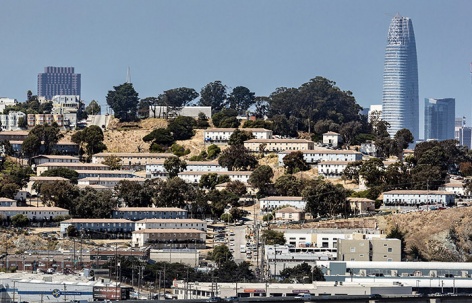
“占地38英亩的社区将拥有一个独特的开放空间网络,包括露台、坡地公园、社区服务设施和街道,并通过Potrero Hill南面山坡上的景观阶梯连接在一起。此外,社区中还将增加1000套市场价格的住宅以及福利住房,配备日托中心、幼儿园、社区中心、娱乐休闲设施、社区商店和开放空间等。评审团称赞该设计方案为:“巧妙地将经济适用房结合至密集地形,定义了公共空间的新层次”。
– 2022年评审委员会The 38-acre neighborhood will have a unique open space network of terraces, sloping parks, community services, and streets linked together by landscaped staircases carved from the south-facing slopes of Potrero Hill. Also being added are 1000 units of market rate and affordable homes, day care, pre-school, community center, recreational facilities, neighborhood serving retail, and open space amenities. The jury praised the urban design as a “masterful integration of affordable housing into intense topography that defines new hierarchies of public space.”
– 2022 Awards Jury
来自 ASLA 对gooood的分享。
HOPE SF: Rebuild Potrero | GLS Landscape | Architecture
项目陈述
PROJECT STATEMENT
在快速密集化的旧金山,Potrero重建项目坐落于景色壮丽然而地形异常陡峭的场地上,试图在重塑公共住房的同时为弱势公民提供庇护,使其免于流离失所。原本的606套旧公共住房被更加密集且多样化的住房类型所取代。占地38英亩的社区将拥有一个独特的开放空间网络,包括露台、坡地公园、社区服务设施和街道,并通过Potrero Hill南面山坡上的景观阶梯连接在一起。重新连接起来的街道网格将支撑密度更高且更加独特的景观,并将取代低密度的郊区规划,从社会和物理层面上,改变附近历史悠久的工人阶级社区和交通服务设施相互隔绝的现状。
对社区的维护是该项目的一个重要组成部分。得益于细致谨慎的分期建设,现住的居民在整个建造过程中都无须搬离场地。住宅项目的第一阶段已经完成,并于2019年春天开放入住。
In rapidly densifying San Francisco, on an extraordinarily steep site with dramatic views, Rebuild Potrero is reinventing public housing while providing vulnerable citizens a refuge from displacement. 606 units of aging public housing are being replaced by a denser and more diverse mix of housing types. The 38-acre neighborhood will have a unique open space network of terraces, sloping parks, community services and streets linked together by landscaped staircases carved from the south-facing serpentine slopes of Potrero Hill. A reconnected street grid supporting higher densities and dramatic views will replace the low density suburban plan, which has left the neighborhood socially and physically isolated from the adjacent historic working class neighborhood, transit and services.
A crucial component of the project is the commitment to maintain community. By carefully phasing construction, current residents will not be relocated off site at any time during the process. The first phase of housing has been built, and was occupied in Spring 2019.
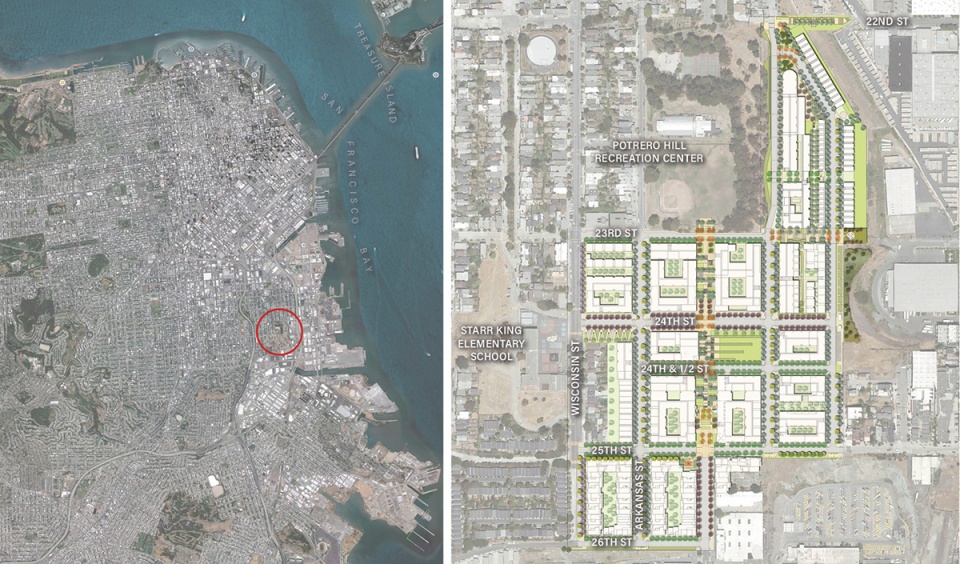
▲38英亩的总体规划:在旧金山快速密集化的背景下,Potrero重建项目位于一处极其陡峭的地块上,同时拥有开阔的视野。在重塑公共住房的同时,该项目也为弱势居民提供了庇护所,使其免于陷入流离失所的境地。38 Acre Master Plan. In rapidly densifying San Francisco, on an extraordinarily steep site with dramatic views, Rebuild Potrero is reinventing public housing while providing vulnerable citizens with a refuge from displacement. © GLS Landscape | Architecture
项目说明
PROJECT NARRATIVE
Potrero排屋和附属建筑位于旧金山的一处位置显著的山顶上,容纳了大约1200位居民,其所在场地的下方曾经是Mission Bay的铁路站场。这处老旧的公共住宅区最初是为造船厂的工人建造,现作为HOPE SF开发项目的一部分进行改造和激活,由当地市政府、州政府、联邦政府以及当地开发商共同出资,是一个公共和私营的合作项目。特殊的湾边场地位于Potrero Hill公园下方,是旧金山独特的城市形态所造就的天然山顶公园之一。如今,该地块被笼罩在新建的Salesforce摩天楼的阴影之下,后者反映了旧金山经济发展的两面性,以及高昂房价给居民造成的压力。基于以上背景,本次规划的核心是通过细致谨慎的分段式设计和建造,避免让任何居民陷入流离失所的境地。
Potrero Terrace住宅建成于1941年战争期间,附属建筑出现于1954年。场地中的街道顺着陡峭的地形轮廓修建,导致房屋的密度受到严重限制。低密度的郊区规划使该社区与附近历史悠久的工人相互隔绝,并脱离于当地的交通和服务设施,仿佛已经不是旧金山的一部分。社区的重新设计及其与旧金山的重新连接,是基于广泛的、经过多年审批和社区外联行动而得以实现。该过程调整了传统的城市设计策略:在起伏明显的地形上设置一个无差别的垂直网络——这种模式曾塑造了旧金山的显著特征。除了创造以性能为驱动的基础设施,以及在数量和质量上远超于传统标准的开放空间网络,新的网格还包含了一个由公园、阶梯和一系列狭窄街道组成的大尺度步行网络,使行人与车辆同等优先,步行环境更加安全便捷,同时更加开放于社区、公共交通和其他城市服务。在对旧金山传统进行重新诠释的过程中,三条倾斜率超过18%的陡峭街道被改造为公共楼梯,并被设计为多功能的元素,不仅为行人提供了连接路径,还通过雨水处理和由宽敞的交通动线及景观平台带来的户外空间,大幅地提高了景观的性能和实用性。
新街道网格的平均倾斜率超过15%,将为更高密度和景观更加独特的住房类型集群提供支撑。在20年的时间里,既有的606套旧公共住房单元将被取代,并将增加1000套市场价格的住宅以及福利住房,配备日托中心、幼儿园、社区中心、娱乐休闲设施、社区商店和开放空间等。一期基础设施于2018年完工,一期住房于2019年春季开放入住。目前项目已投入二期基础设施及住房的设计和建造。
规划的核心是一个十字形的开放空间,它提供了一条从新社区中心通往现有社区公共设施(Potrero Hill 公园和休闲中心以及Starr King小学)的人行通道。社区中心被特意沿着场地内最为平坦的街道布置。第24街将作为巨大的南向社区平台,连接占地3/4英亩的公园、社区建筑(占据一整个街区,带有社区服务设施)、零售服务、老年公寓和另处绿色连接带(Squiggle公园),其中Squiggle公园包含数个三角形花园,其边缘的无障碍路径通往场外区域以及附近的小学。占地3/4英亩的中央公园位于社区中心和老年公寓之间,包含一个“Dolores公园”式的斜坡草坪,享有朝向南湾的全景视野。极端的地形为空间的多样性和创造性提供了无限的机会。参照旧金山在街区空隙中置入楼梯的传统,毗邻公园的大楼梯为街区之间提供了必要的步行连接,同时带来宽敞的阶梯式观景台以及现代化的雨水处理系统。
第22街设有三座人行楼梯,最北端的一座专用于连接居民与附近的Caltrain车站,该车站是当地区域交通的连接站。地势最平坦的几条街道上设置了专用的自行车道,并确定了关键的公交站点,以最大限度地利用公交系统。社区花园(未来计划扩建至1英亩)设置在平台上,可以眺望东海湾,并有机会与下方的旧金山食品银行开展联合项目。街道设计进一步推进了旧金山“Better Streets Plan”规划方案中的提议,旨在确保街道在满足步行、骑行、树木绿化、雨水管理和基础设施等多种功能的同时,成为亲切且受欢迎的场所。人行道上的雨水将被排放至人行道与路缘之间的公园透水带。树木的选择以耐受度、低维护、低用水量和对既有蛇纹岩土壤的适应力为原则。道路本身不提供灌溉系统,灌木和地被植物将选种能够适应本地气候的原生亚热带沙漠植物。
在调整场地高差之前,项目团队根据能够适应蛇纹岩土壤的本地物种清单和采种情况,沿着场地边界进行了恢复性的种植。由于场地中大部分是断裂的蛇纹岩,在不干扰邻近地带的前提下实现雨水渗透的机会十分有限。为此,项目采用的策略是将雨水收集到介于街区之间的蓄水池中,并在现场进行雨水的再利用,同时选择将雨水缓慢地排放至旧金山市的联合污水处理系统中。雨水不仅可以用于补充灌溉,还可用于未来街区的厕所冲洗。雨水花园和植被沼泽将用于减缓雨水流入蓄水池的速度。平行泊车区采用透水铺装,也可以缓冲和减少径流。项目的设计符合LEED ND金级认证和当地绿点评级系统对可持续发展的要求,以及旧金山公用事业委员会严格的雨水处理限制(雨水必须得到储存,以应对旧金山不断老化的污水和雨水处理系统)。街道和公园使用低能耗的LED灯作为照明设施。
该规划将为该社区未来20年的发展和建设提供指导。
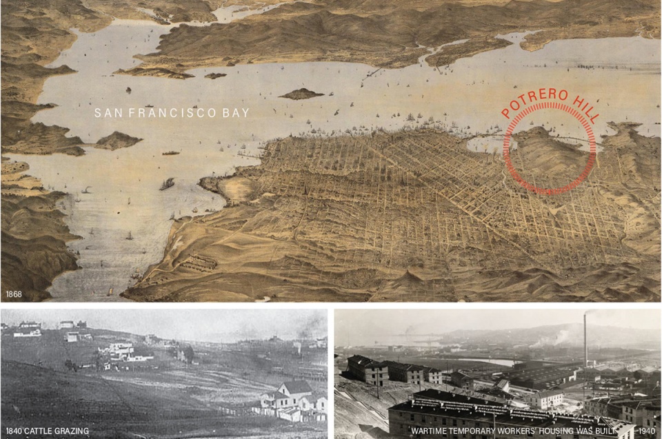
▲场地历史: Potrero排屋和附属建筑分别建造于1941年和1954年的战争时期,最初被用作临时性的工人住房,后来又被改建为公共住房,并随着时间推移而变得破旧。Site History. The Potrero ‘Terrace’ and ‘Annex’ were completed during the war effort in 1941 and in 1954, respectively. Though the barracks were built as temporary worker housing, they were converted to public housing and devolved into decrepit conditions. © David Rumsey Maps
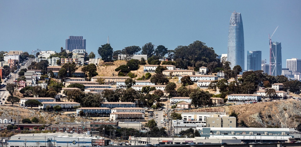
▲在旧金山中产阶级化背景下逐渐衰退的公共住宅:破旧的Potrero排屋和附属建筑与高耸入云的Salesforce大楼形成了鲜明对比,后者是旧金山市中心数字经济繁荣的象征,同时也反映了收入不平等和住房严重短缺的问题。Deteriorating Public Housing in the Shadow of San Francisco Gentrification. The derelict ‘Potrero Terrace and Annex’ stands in contrast to the soaring Salesforce Tower, which is a symbol of prosperity created by the new digital economy in downtown San Francisco, as well as income inequality and a severe housing shortage. © Kyle Jeffers
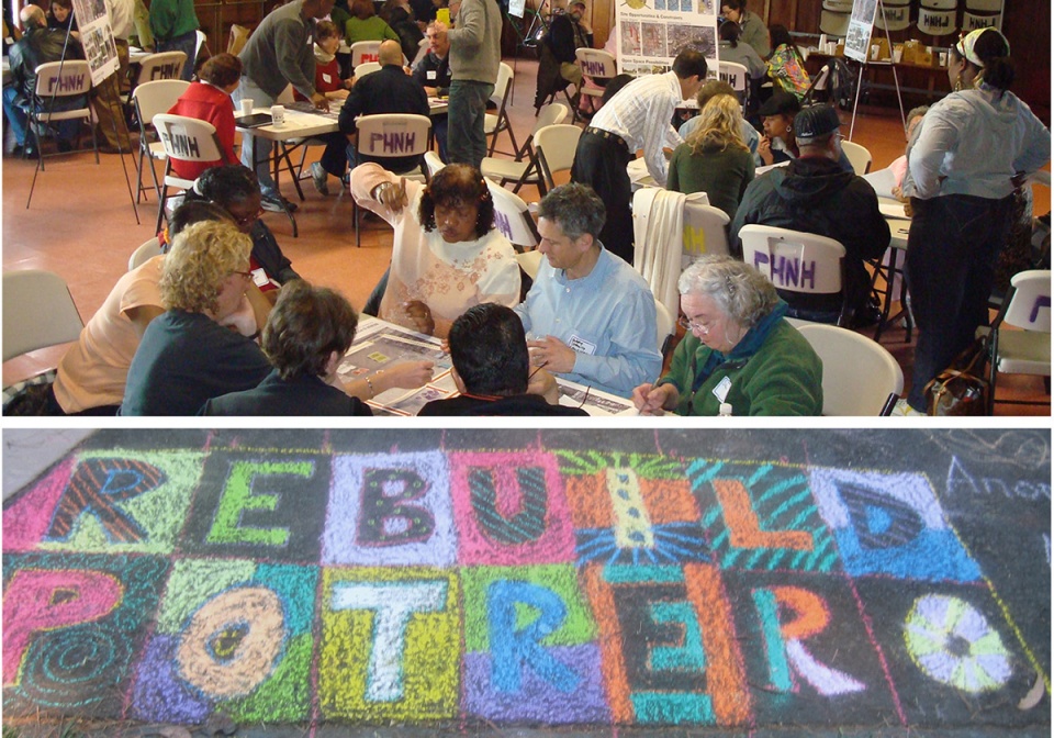
▲包容性的设计:设计团队在项目的各个阶段都征求了社区的意见,使居民能够亲自参与设计方案的制定,同时与社区建立互相信任的关系。Inclusive Design. The design team solicited input from the community in all stages of the design process, to empower residents in participating in the formulation of the design principles and to build trust with the community. © BRIDGE Housing
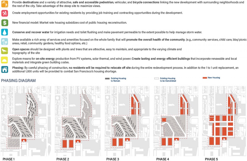
▲社会和环境可持续原则:得益于细致谨慎的阶段式设计,居民们可以无需搬离场地。项目的设计符合LEED ND金级认证和当地绿点评级系统对可持续发展的要求,以及旧金山公用事业委员会严格的雨水处理限制。Social and Environmental Sustainability Principles. Through careful phasing, no residents are required to re-locate, and the project has been designed to meet the sustainability requirements of LEED ND Gold, the local Green Point rating system and the SF Public Utility Commission’s stringent stormwater requirements. © GLS Landscape | Architecture
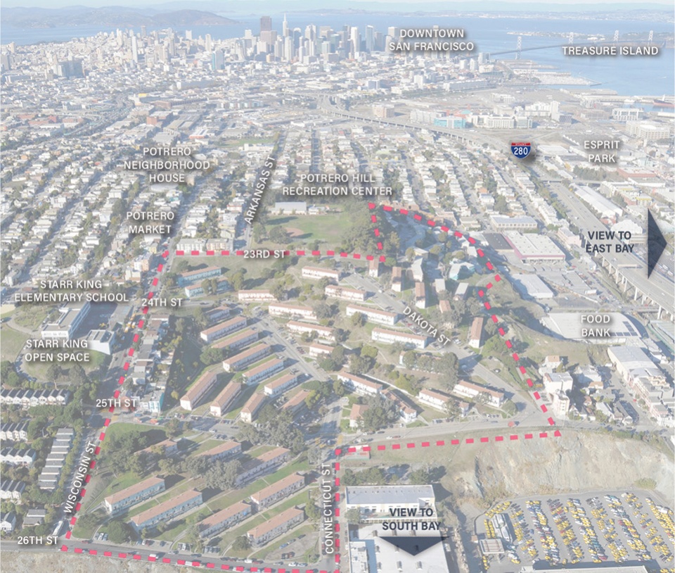
▲被孤立的社区:社区内的街道并未与其附近的街道网格进行连接,而是依照既有山脊和山谷的轮廓线顺势而建。这种做法导致社区脱离于周边区域,从物理和社会层面上将居民隔绝于附近的社区。Isolated Existing Neighborhood. Rather than relating to the adjacent street grids, streets followed contours of an existing ridge and valley according to expediency. This resulted in few connections to the surrounding area, leaving residents both physically and socially isolated from the surrounding neighborhoods. © GLS Landscape | Architecture / Van Meter Williams Pollack
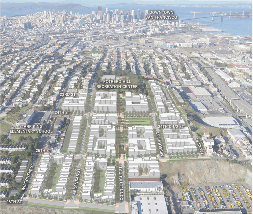
▲与城市网格相连的新规划方案:新的街道网格能够为更高密度且独特的景观提供支持,并将取代低密度的郊区用地规划,改变社区与附近历史悠久的工人阶级社区相互隔绝的现状,并重新与交通和服务设施建立连接。New Plan Connects to the City Grid. A new street grid supporting higher densities and dramatic views will replace the low density suburban site plan, which has left the neighborhood socially isolated from the adjacent historic working class neighborhood and physically isolated from transit and services. © GLS Landscape | Architecture / Van Meter Williams Pollack
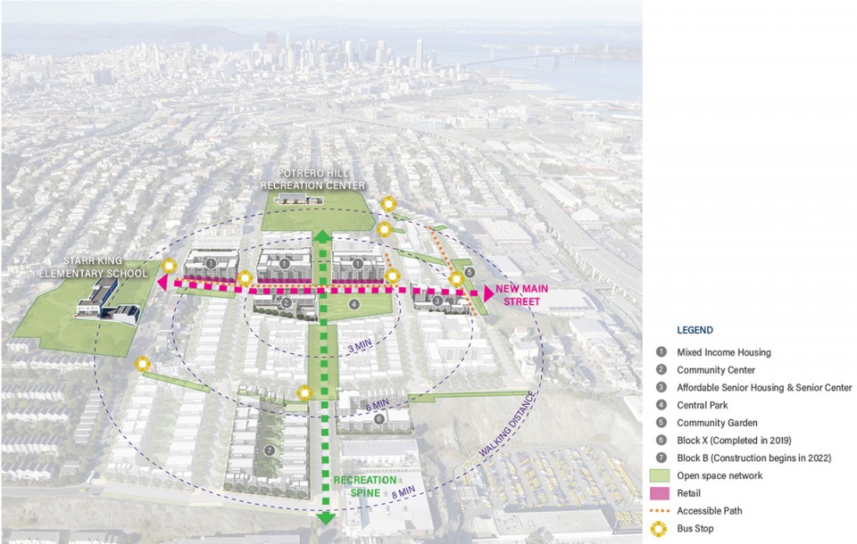
▲中心位置和便利的公共设施:规划的核心是一个十字形的开放空间,它提供了一条从新社区中心通往既有社区公共设施(包括Potrero Hill公园和休闲中心,以及Starr King小学)的步行路径。Centrally Located and Accessible Public Amenities. The centerpiece of the plan is a cross-shaped open space that provides a pedestrian thoroughfare from the new neighborhood center to existing community assets: Potrero Hill Park and Recreation Center, and the Starr King Elementary School. © GLS Landscape | Architecture / Van Meter Williams Pollack
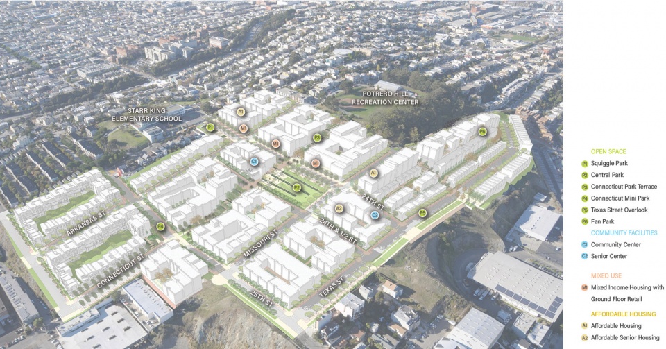
▲开放空间网络内的设施:规划的核心是一个与Potrero Hill休闲中心相连的大型公园,其内部设有可停留的步行台阶和平台。社区设施位于第24街沿线,是场地中最平坦的一条街道。Amenities Located Within the Open Space Network. At the heart of the plan is a large park connected to the Potrero Hill Recreation Center with occupiable pedestrian steps and terraces, and community facilities located along 24th street which is the flattest street on the site. © GLS Landscape | Architecture / Van Meter Williams Pollack
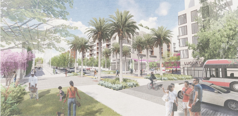
▲开放空间的连接:规划的核心区域位于第24街,连接了社区设施和强大的市政核心,并通过一个安全且无障碍的开放空间将整个社区统一起来。Open Space Connections. The centerpiece of the plan is located at 24th street, linking community assets and transit with a strong civic core while unifying the neighborhood with a safe, accessible open space. © GLS Landscape | Architecture
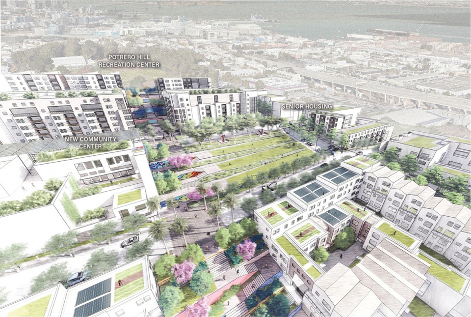
▲用旧金山典型的大楼梯连接开放空间:第24街的中央公园沿袭了旧金山景观楼梯的传统和经典的“Dolores公园”设计类型,在Potrero Hill创建了一个充满活力的新开放空间。San Francisco Stairway Typology Links Open Spaces. The 24th Street Central Park capitalizes on a tradition of San Francisco landscaped stairs, and steep sites with dramatic views to the bay using a classic SF “Dolores Park” typology, creating a vibrant new open space destination on Potrero Hill. © GLS Landscape | Architecture
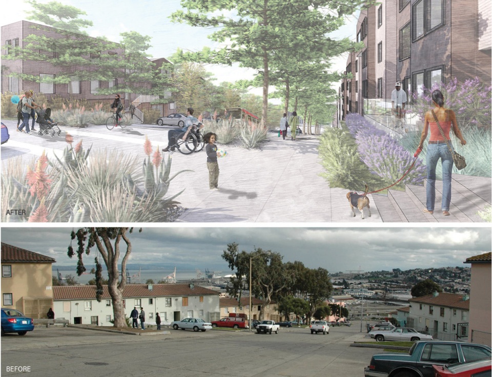
▲用步行街取代以汽车为主导的景观:由公园、阶梯和拓宽的街道构成的网格容纳了大规模的人行道网络,实现了人车分流,让社区变得更安全、便捷和开放,同时更容易连接到公共交通和其他城市服务。Walkable Streets Replace Auto-Dominated Landscape. The grid accommodates an extensive pedestrian network of parks, stairs and widened streets, giving as much priority to people as to cars, making a safer, more accessible and open neighborhood with greater access to public transit and other city services. © GLS Landscape | Architecture
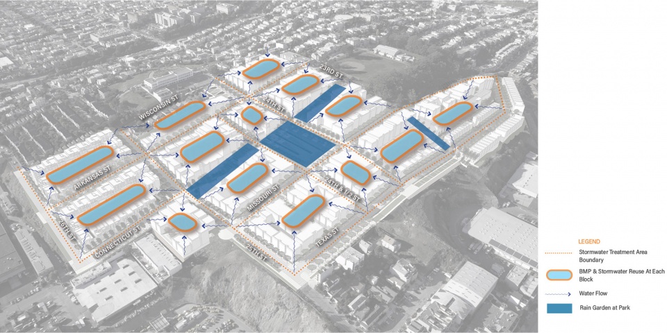
▲陡峭地形上的集水区:场地既有的地理条件使雨水渗透变得不易。为此,设计采用的策略是将雨水收集至蓄水池中,然后缓慢地排放至联合污水处理系统,或将其重新利用于灌溉和厕所冲洗。Constructed Watershed for Steep Topography. Due to existing serpentine conditions, there are limited opportunities to infiltrate stormwater on site. The strategy then, is to collect stormwater in cisterns and slowly release it into the combined sewer system or reuse it for irrigation and toilet flushing. © GLS Landscape | Architecture
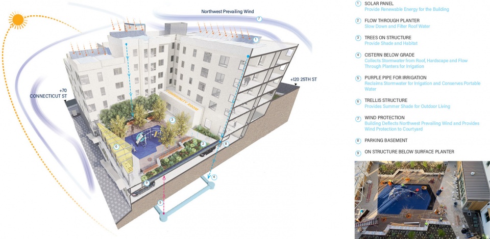
▲已完工的第一个街区:X街区是该项目第一个建成的街区,它体现了雨水回收策略,利用50英尺的地势落差将雨水储存至建筑基座下方,便于灌溉和重复利用。First Block Completed. Block X, the first built block of the project, demonstrates the stormwater reclamation strategy, taking advantage of the 50-foot grade difference to store rainwater under the building foundation for irrigation reuse. © GLS Landscape | Architecture / Patrick Argast
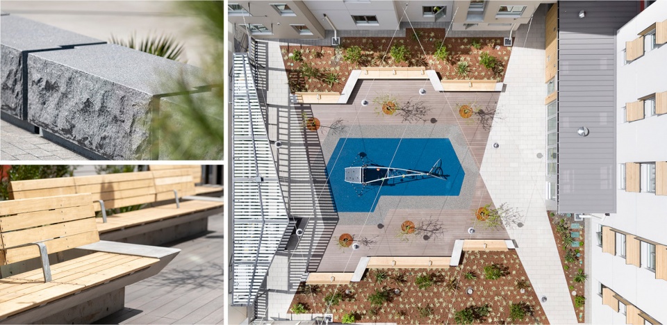
▲已完工的第一个街区:居民于2019年4月搬入位于康涅狄格大街1101号的X街区。得益于阶段式的施工,他们全程无需搬离住所。First Block Completed. Residents moved into Block X at 1101 Connecticut Street in April 2019. Due to phased construction, they were able to stay onsite throughout the entire process. © Patrick Argast
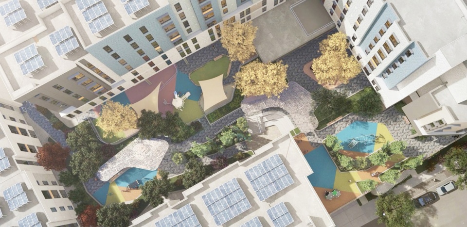
▲即将动工的第二个街区:新的大型中央庭院将很快投入建设,其内部包含一个大型的托儿设施和一个街角口袋公园。Second Block to Break Ground Soon. A large new central courtyard with a major childcare facility and a corner pocket park are to be underway soon. © YA Studio
PROJECT NARRATIVE
Located in San Francisco on a prominent hilltop above the former railyards of Mission Bay the ‘Potrero Terrace and Annex’ is currently home to approximately 1,200 people. Originally built for shipyard workers, the aging public housing site will be revitalized as part of the innovative HOPE SF program, a public/private partnership which teams city, state and federal funding with local developers. The dramatic bayside site lies just below Potrero Hill Park, one of the original topographically derived hilltop parks resulting from the unique urban pattern of San Francisco. Today the site also lies in the shadow of the new Salesforce Tower, a bittersweet symbol of San Francisco’s economic exuberance and as well as its lack of affordability. Central to the plan then, is the commitment to prevent displacement of any residents, through carefully phased design and construction.
The ‘Potrero Terrace’ was completed during the war effort in 1941 and the ‘Annex’, was added in 1954. Streets pragmatically followed the contours of the steep topography resulting in severe limitations on housing density. The low density suburban site plan, has left the neighborhood socially isolated from the adjacent historic working class neighborhood and physically isolated from transit and services. It does not feel like a part of San Francisco. The redesign and re-connection of the neighborhood to San Francisco is based upon an extensive multi-year agency approval and community outreach process conducted on the site, which has led to an adjustment of the traditional urban design strategies that created San Francisco’s distinctive character which drapes an undifferentiated grid over dramatic topography. Along with new performance driven infrastructure and a network of open spaces far exceeding traditional standards for amount and quality, the grid accommodates an extensive pedestrian network of parks, stairs and narrowed streets, giving as much priority to people as to cars, making it safer, more accessible, and more open to neighbors, public transit and other city services. In an interpretation of the San Francisco tradition, three street right-of-ways that are too steep for vehicular access, at over 18%, are transformed into public stairways. The stairs are designed to be multipurpose elements providing pedestrian connections, but also vastly improving performance and usability by processing rainwater and providing usable outdoor space with generous circulation and landscaped terrace landings.
The new grid of streets averaging over 15% slope will support a greater mix of housing types with higher densities and dramatic views. Over a 20 year period, the 606 existing dilapidated public housing units will be replaced along with an additional 1000 units of market rate and affordable homes as well as on-site day care, pre-school, community center, recreational facilities, neighborhood serving retail and the open space amenities. The first phase of infrastructure was completed in 2018, and first phase of housing was occupied in Spring 2019. Design is currently underway on the second phase of infrastructure, as well as the second phase of housing.
The centerpiece of the plan is a cross-shaped open space that provides a pedestrian thoroughfare from the new neighborhood center to existing community assets; Potrero Hill Park and Recreation Center, and the Starr King Elementary School. The neighborhood center is purposefully arranged along the flattest street on the site. 24th street will function as a huge south facing community terrace linking together a ¾ acre park, a community building (which occupies an entire block with neighborhood serving facilities), retail services, senior housing and another green connector (Squiggle Park) which includes triangular gardens along an accessible path to the offsite and adjacent elementary school. The 3/4 acre Central Park, between the Community Center building and the senior housing, has a sloping ‘Dolores Park’ type lawn with uninterrupted views to the South Bay. The extreme topography creates endless opportunities for spatial variety and invention. In the tradition of San Francisco midblock staircases, the grand stair adjacent to the park provides the requisite pedestrian connection between blocks combined but also with generous terraced overlooks and modern stormwater functions.
The northernmost of the three pedestrian stairs on 22nd Street is dedicated specifically to connect residents to the nearby Caltrain Station that is a regional transit link. The plan accommodates dedicated bicycle lanes through the site on the flattest streets and key locations have been identified for bus/transit stops to maximize transit. A community garden, which has the potential to expand to 1 acre, is located on a terrace with views to the east bay and opportunities to develop joint programs with the San Francisco Food Bank located just below. Street design furthers the recommendations of the San Francisco Better Streets Plan, which ensures that streets are inviting, while performing the multiple functions of accommodating pedestrians, bicycles, trees, stormwater management and infrastructure. Stormwater from sidewalks drains to pervious park strips between the sidewalk and the back of the curb in the right of ways. Trees have been selected for longevity, ease of maintenance, low water use and adaptability to the existing serpentine soils. No irrigation will be provided in the right-of-ways. Shrub and ground cover plantings will be native, climate adapted and subtropical desert plantings.
Restoration plantings along the site borders will be based on an inventory of serpentine tolerant native species and seed collection prior to site grading. Due to the properties of the fractured serpentine rock that covers a majority of the site, there are limited opportunities to infiltrate stormwater on site without endangering adjacent properties. The strategy then, is to collect stormwater in a series of midblock cisterns, reuse it on site, and/or slowly release it into the San Francisco combined sewer system. Stormwater may be used to offset irrigation and is available for reuse in toilet flushing in the future blocks. Rain gardens and vegetated swales will be used to slow stormwater flow into the cisterns. Permeable paving will also be used in parallel parking areas to slow and reduce the amount of runoff. The project has been designed to meet the sustainability requirements of LEED ND Gold, as well as the local Green Point rating system, and the SF Public Utility Commission’s stringent stormwater requirements which require rain water storage in response to San Francisco’s aging combined sewer and stormwater system. Street and park lighting use low energy LED fixtures.
The plan will guide the build-out of this new San Francisco neighborhood over the next 20 years.






改之前孤立在城市之外,改完后和城市融为一体了。
我们也需要社区重建
很不错的规划改造方案
你小子住谷德是吧