“五大湖沿岸地区虽然并未受到像沿海地区那样多的关注,但它们对于理解气候变化有着同样重要的作用。在五大湖沿岸的三个不同的位置,不断变化的土地——即构成了屏障沙堤、沙丘和湿地的沉积物成为了本次跨机构研究的对象,其目的是将这些地带从气候导致的退化中重新恢复过来。在伊利湖和安大略湖,从航道中挖出的沉积物将用于沙堤和湿地区域的关键栖息地的重塑。在密歇根湖,方案提出建造水下石脊,以尽可能地减少浪潮对沙丘的冲击以及对湖面的视觉干扰。集中地处理本地问题,将有助于找到广泛适用于整个地区的具体解决方案。”
– 2020年评审委员会“The coasts of the Great Lakes don’t always get as much attention as their oceanic counterparts, but they are just as essential in understanding climate change. In three locations, shifting lands—the sediment that makes up their barrier sandbars, dunes, and wetlands, respectively—have become the focus of a multi-agency study that aims to restore these coasts from their climate-related degradation. In Lakes Erie and Ontario, sediment dredged from shipping channels will be used to restore the critical habitats of sandbars and wetland areas. In Lake Michigan, the plan calls for the creation of underwater ridges that would minimize both wave impact on the dunes and visual impact on the Lake. Concentrating on the local issues allows concrete solutions with broader implications across the region.”
– 2020 Awards Jury
来自 ASLA 对gooood的分享。
Sensitive Structures: A Landscape Approach for Great Lakes Coasts | Healthy Port Futures
项目概述
PROJECT STATEMENT
该项目对五大湖沿岸的港口和码头进行了重新定位,使其成为生态健康的驱动力,并发挥其对于文化和经济的传统推动作用。主要的实现方法为:关注沉积物及其管理,在整个地区的近岸栖息地重新设计和恢复公共景观。项目团队与多方利益相关者合作,根据人口和城市形态、近岸水陆生态区、沉积物类型和数量以及浪潮和洋流等环境条件来明确各流域的区域特征,并在其中三个区域推行了试点项目,用以展示敏感结构如何适应不同的场地条件,以及如何应对截然不同的资金流和监管环境。此次工作的成果将直接影响相关政策的制定和疏浚实践,并为地方、郡县、州乃至联邦级别的基建工程提供资料。
该项目被命名为“健康的港口未来”,共将历时四年来完成。项目团队由景观设计师领导,成员包括来自各地区的利益相关者与合作者。五大湖保护基金将为项目提供资助。
Our project repositions ports and marinas in the Great Lakes Basin as drivers of ecological health alongside their traditional role as cultural and economic engines. This is achieved through a focus on sediment, its management, and the ways this informs the design and restoration of public landscapes in critical nearshore habitats across the region. We worked with stakeholders and collaborators to characterize regions in the basin by their population and urban form, aquatic and terrestrial nearshore ecotones, sediment type and quantity, and environmental conditions such as waves and currents. Pilot projects were proposed for three of those regions to demonstrate how sensitive structures adapt to these various conditions while working with radically different funding streams and regulatory environments. The outcomes of this effort are directly affecting policy, dredging practices, and informing current capital projects at the local, county, state, and federal level.
The project is a four year effort– Healthy Port Futures– led by landscape architects and including stakeholders and collaborators in each region. It is funded by the Great Lakes Protection Fund.
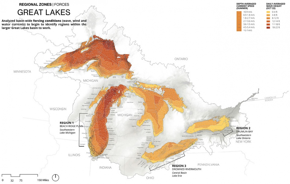
▲五大湖流域-硬性自然条件:项目对五大湖流域进行了分析,以确定出具有特殊水流、波浪和风等特殊自然条件的地点,并利用这些条件来开展富有成效的行动。Great Lakes Basin: Forces: Analysis was conducted at the basin scale in order to establish locations that exhibited particular currents, wave, and wind forcing conditions to be leveraged for productive actions. ©Healthy Port Futures
项目说明
PROJECT NARRATIVE
区域现状
五大湖区的现状预示着气候变化对于其他港口地区的影响。如今整个流域的水位已处于历史高位,对财产、公共空间和栖息地均造成了巨大的损失。相比于单纯的水位上升问题,使其的情况要更加复杂。在过去十年间,水位的波动在过去十年间分别达到了峰值和最低值,增加了风险管理、修复以及港口保护的不确定性。开发出能够解决这些前所未见的问题的规划和设计方案是十分必要的,因为我们正依赖着这样的景观,它与我们的居住、农业生产、休闲、生态和工业用地以及文化和历史场所的塑造都有着密不可分的联系。在区域和地方范围内,利用沉积物进行规划和设计,这为我们提供了一种通过景观学来重新构建基本美学以及解决城市问题的方法。
通过分析和规划,项目团队利用了强制性的条件,让这些针对沉积物的项目产出更加理想的文化和生态成果。具体的方式并不仅仅是要防御既有的风险,而是需要通过一种能够整合这些力量的方法来长期地发挥作用。事实证明,景观设计学是能够整合这一过程的高效学科:它可以将大量与沿海设计相关的学科联系起来,同时将项目的分析、扩展、设计、监管和反应等各个阶段综合为一个整体。在该项目中,一系列敏感结构被建造在三个不同的地点,它们将根据其各自的环境背景,随着时间的推移持续产生作用。
敏感结构
在根据提议而产生的每一个具体案例均对该区域以及地方的自然环境力、历史、经济和文化价值做出了敏感的回应。这种敏感度不仅体现在它们与环境力(例如浪潮、风和新生植被)的交汇和互动上,还反映在其作为结构本身,能够通过拓展、合作与持续不断的修正,促成了对当地沉积物管理方案的一致选择和理解。这些敏感结构是针对史无前例的环境条件而规划,既能够满足社区的近期目标,又为获取系统知识以及适应新条件和未来目标提供了实验性的工具。
实施地点
该项目从整个五大湖流域的规模入手。分析阶段的一个重要内容是界定出干预的范围,明确关键的合作伙伴,找到能够展示出多种自然力、跨越流域地理范围并包含大规模部署潜力的地点,其目标是通过地方干预对整个流域产生影响。最终选定的三个地点为:俄亥俄州的洛雷恩港(伊利湖)、纽约州Port Bay休闲码头(安大略湖)以及伊利诺伊州的海滩州立公园(密歇根湖)。
介入与合作
纽约州,Port Bay | 鼓丘 / 海湾系统
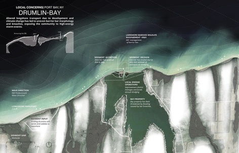
位于纽约州北部的Port Bay,其沿岸景观由一系列鼓丘崖壁构成,它们缓慢地受到侵蚀,并通过海岸运输路线将沉积物送往东部。这些沉积物往往会形成屏障式的沙堤,将一系列湾区与安大略湖相隔开。社区在Port Bay主要关注两个独立却又彼此关联的主题:一是连接湾区和安大略湖的小型河道的疏浚工作,以及对于沉积物的处理——通常,包含大量鹅卵石的沉积物会被简单地放置在尽可能靠近河道的位置,以实现最低的成本。二是河道东侧防护沙堤的修复问题——近几年来,这些沙堤频繁地受到湖水波浪的冲击。虽然这是自然形成的结果,但由于缺乏沉积物,沙堤在过去的十年间一直未能有效地恢复。
项目团队与州环境保护部门、韦恩郡水土部门、Port Bay改良区以及当地的疏浚承包商进行了合作,在不增加社区成本的前提下,将每年一次的疏浚工作与沙堤的修补潜力结合起来。具体的做法是将沉积物材料置入近岸地带水线下方的鼓丘填料区,在疏浚作业和人类可感知的尺度下重新恢复该区域的鼓丘活动,从而借助波浪的作用迅速侵蚀薄弱的沙堤。这一措施从2020年夏季开始实施并对其进行监测,以便在接下来的几年中对可侵蚀的崖壁的形式及位置进行必要的调整。
伊利诺伊州,海滩州立公园 | 山脊-洼地
伊利诺伊海滩州立公园的地形以滩脊平原为主。该地貌由一系列与湖岸平行的沙脊构成,期间分布着湿地。滩脊产生的栖息地,尤其是位于其中的丘间湿地属于非常罕见的地理环境,是州政府机构的重点保护对象。然而作为一个动态的系统,公园的滨水环境在不断发生变化,目前公园北部和南部已经分别呈现沉积物净侵蚀和净增状态。气候的变化和风暴强度的增加进一步加剧了这一过程,并加剧了沿岸泥沙的运输活动。由于地貌的迅速侵蚀,原本花费数千年才形成的栖息地在短短几个月或几年内便被一洗而空。
在与州自然资源部、伊利诺伊地质服务部门、美国陆军工程部队以及当地治沙工作组的合作下,项目团队发现了能够将山脊-洼地地形扩展到近岸水生环境的契机:利用加厚的滨水景观,在不影响沿岸沉积物运输的前提下减缓侵蚀,同时提供新的水生栖息地。规划方案试图通过一组可变形的水下石脊来有效减弱波浪的冲击,在成功的情况下,这一举措将在保护珍贵栖息地的同时,避免修筑地上防波堤可能带来的视觉障碍和昂贵成本。
俄亥俄州,洛雷恩港 | 工业河口
伊利湖南岸的地质主要来源于冰川作用下形成的湖床沉积物,如今这里已经成为俄亥俄州最优质的农业用地。这片堆满淤泥的农田被侵蚀为流速缓慢的河流,经由河口地带汇入伊利湖。位于河口沿岸的市镇中包括城市中几个最多产的工业和制造业中心,宝贵的湿地生态系统的流失亦是工业发展遗留的问题之一;航行需求则导致船运通道不断地被疏浚。俄亥俄州已经为此制定了新的法规,暂停在公开水域堆置疏浚的沉积物。
项目团队与美国陆军工程部队、周环境保护局、州自然资源部和洛雷恩都会公园进行了合作,提出在弧形的石砌墙体后方利用疏浚产生的沉积物建造一系列多孔湿地。俄亥俄州已经失去了高达80%的湖岸湿地,因而创建新的湖岸湿地可以说是对疏浚沉积物最为有效的利用。新修筑的结构部分向湖岸敞开,使浪潮逐渐将沉积物塑造成复杂的海岸线湿地,并在风暴期间将部分沉积物释放到附近的岸边。此外,这些结构还将成为富有价值的休闲垂钓地点和湖上风暴期间的避难所。大型的湿地集群还将形成一条从洛雷恩延伸至克利夫兰的、受保护且生态丰富的水路。
从规划到实施
以上提到的所有项目都将在不久的将来完成建设,并将进行后续的监测工作。这些实验性的试点项目是深入且细致的规划、分析、拓展以及与各方机构和利益相关者高效合作的成果。“健康的港口未来”所塑造的一系列敏感结构展示了景观设计在沿海领域的显著发展。
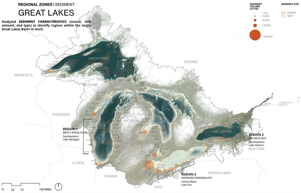
▲五大湖流域-沉积物:沉积物的类型、数量和流动在整个五大湖流域内存在很大的差异。流域尺度下的分析有助于了解这些现状之间的细微差别并找到相应的处理办法。Great Lakes Basin: Sediments: The sediment type, quantity and movement vary considerably across the basin. The basin-scale analysis helped understand the nuance of this condition and how to work with it. ©Healthy Port Futures
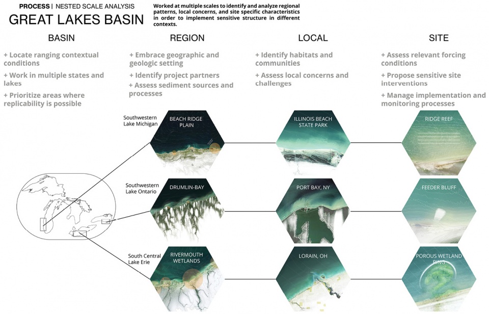
▲嵌套尺度分析:项目在一个多层次的嵌套的尺度下实施,为的是找到并分析每个层级中最具决定性的具体特征,从而制定出一个主次分明的实施层级,这样就无需再对每个层级都进行事无巨细的研究。Nested Scale Analysis: The project worked at multiple and nested scales to identify and analyze the particular characteristics most influential at each. This permitted the development of a hierarchy that established priorities and reduced the need to study everything at every scale. ©Healthy Port Futures
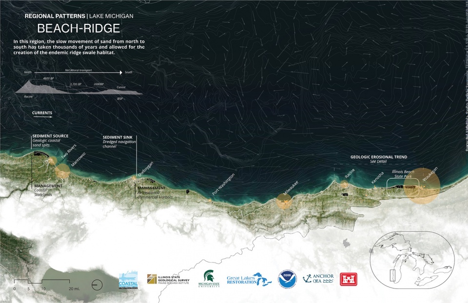
▲滩脊平原-区域平面图:在一系列沿湖沙丘的缓慢移动的影响下,密歇根湖的西部海岸线展示出独特的栖息地和构造,最终形成了滩脊平原的区域特征。Beach Ridge Plain: Regional Patterns: The western shoreline of Lake Michigan exhibits unique habitats and formations due to the slow moving series of coastal dunes, creating the Beach Ridge Plains that characterize this region. ©Healthy Port Futures
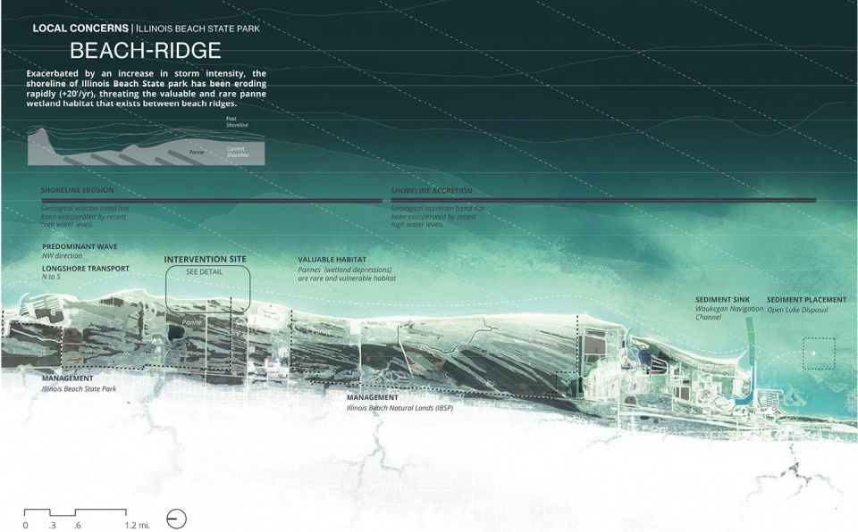
▲滩脊平原-当地条件:伊利诺伊海滩州立公园珍贵的滩脊平原正在以前所未有的速度受到侵蚀,其主要原因是气候变化导致了风暴活动的增加。Beach Ridge Plain: Local Conditions: The valuable Beach Ridge Plain at the Illinois Beach State Park is eroding at an unprecedented rate, due primarily to climate shifts and the associated increase in storm activity ©Healthy Port Futures
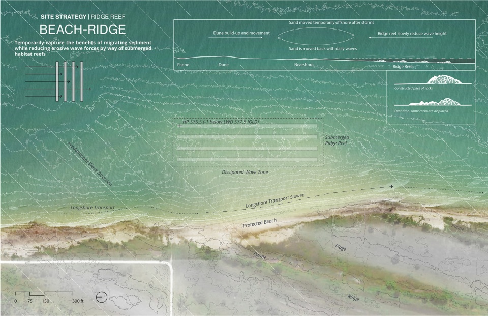
▲滩脊平原-场地自然力和策略:伊利诺伊海滩州立公园的干预措施包括建造水下石脊,以减缓沉积物的运动,保护陆上栖息地免于受到海浪的侵蚀。Beach Ridge Plain: Site Forces and Strategies: The intervention at Illinois Beach State Park consists of a submerged ridge reef, designed to slow sediment moment and protect the valuable terrestrial panne habitat from the erosive forces of waves. ©Healthy Port Futures
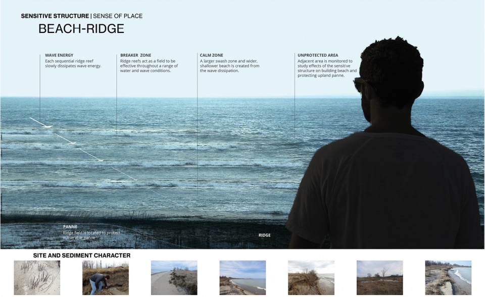
▲滩脊平原-敏感结构:水下石脊能够在不干扰开阔的水域视野的前提下创造出一个能够减缓波浪冲击的区域。Beach Ridge Plain: Sensitive Structure. The submerged ridge reef will create a zone of reduced wave energy without obstructing views of the open water. ©Healthy Port Futures
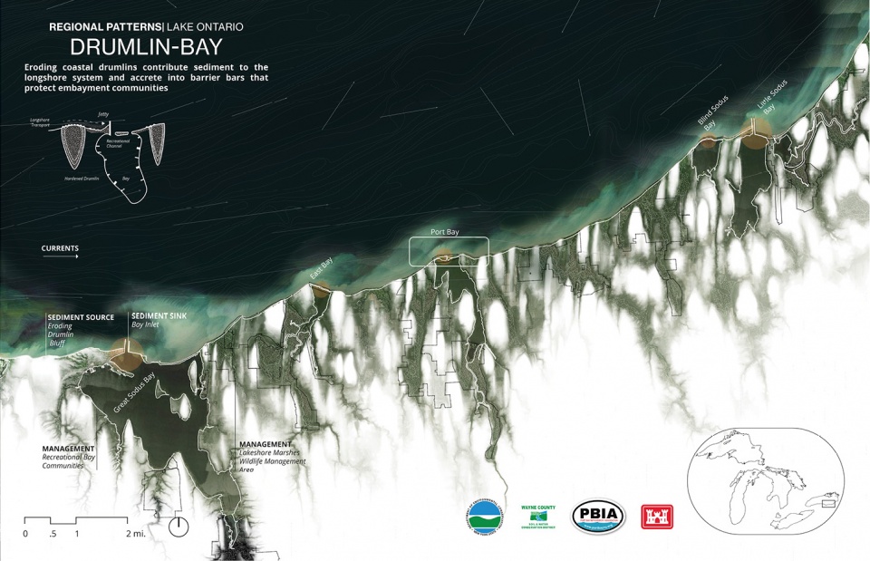
▲鼓丘湾地-平面图:安大略湖南岸的地貌以侵蚀性的鼓丘崖壁为主,它们将沉积物推向湾地,保护沿岸社区免于受到高能量湖泊环境的冲击。Drumlin Bay Complex: Regional Patterns: The geography of the southern shore of Lake Ontario is one of eroding drumlin bluffs that transport sediment across bays and protects embayment communities from the high-energy lake environment. ©Healthy Port Futures
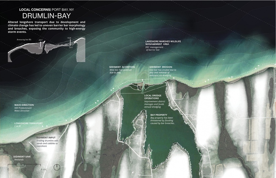
▲鼓丘湾地-当地条件:土地开发和持续对自然侵蚀和运输环境进行控制的做法,导致了沉积物运动量的减少以及防护沙堤的毁坏。Drumlin Bay Complex: Local Conditions: Development and the continued attempts at controlling the natural erosive/transport environment has contributed to reductions in sediment movement and breaches in many of the protective barrier bars. ©Healthy Port Futures
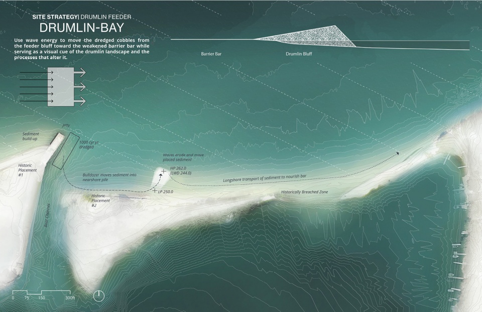
▲鼓丘湾地-场地自然力和策略:Port Bay的干预措施是利用每年一度的疏浚作业所产生的包含大量鹅卵石的沉积物来建造可侵蚀的崖壁。与整个区域的状况相似,崖壁将在波浪的作用下将沉积物向东边输送,起到加固沙堤的作用。Drumlin Bay Complex: Site Forces and Strategies: The intervention at Port Bay is the construction of a feeder bluff made from annually dredged, cobble-rich sediment. Analogous to what happens across the region, the bluff will erode through wave energy and transport material to the east, fortifying the weakened barrier bar. ©Healthy Port Futures
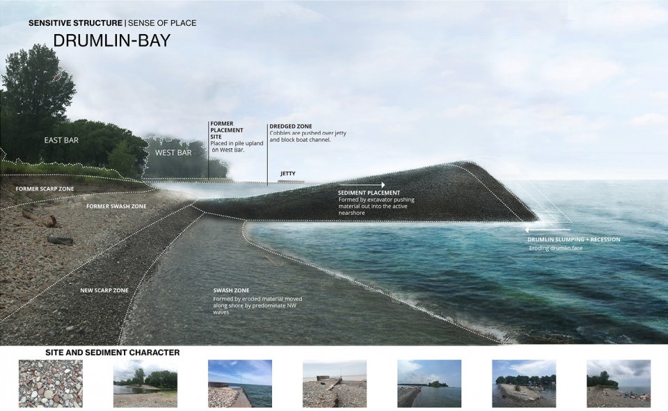
▲鼓丘湾地-敏感结构:由当地挖出的鹅卵石构成的可侵蚀崖壁将成为代表当地地质条件和侵蚀过程的临时性标志,为该区域赋予独一无二的特征。Drumlin Bay Complex: Sensitive Structure: The feeder bluff, made of locally dredged cobbles will serve as a temporary icon of the local geology and the erosive processes that make the region unique. ©Healthy Port Futures
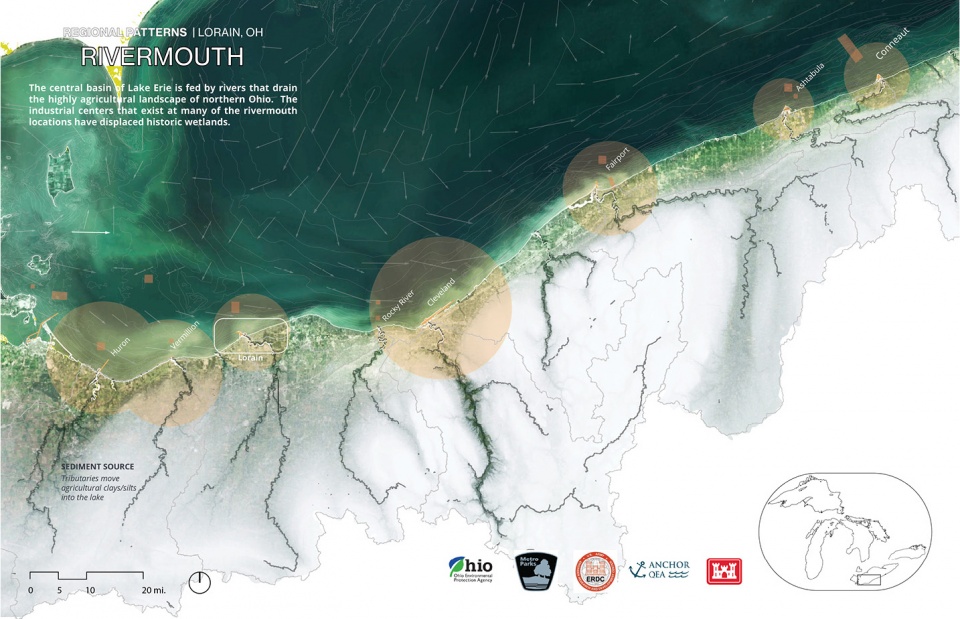
▲工业河口-区域平面图:伊利湖的中心流域由河流提供补给,这也造成了俄亥俄州北部高度农业化景观的日渐干涸。曾经存在的湿地如今已被河口沿岸的数个工业中心所取代。Industrial Rivermouth: Regional Patterns: The central basin of Lake Erie is fed by rivers that drain the highly agricultural landscape of Northern Ohio. The industrial centers that exist at many of the rivermouth locations have displaced historic wetlands. ©Healthy Port Futures
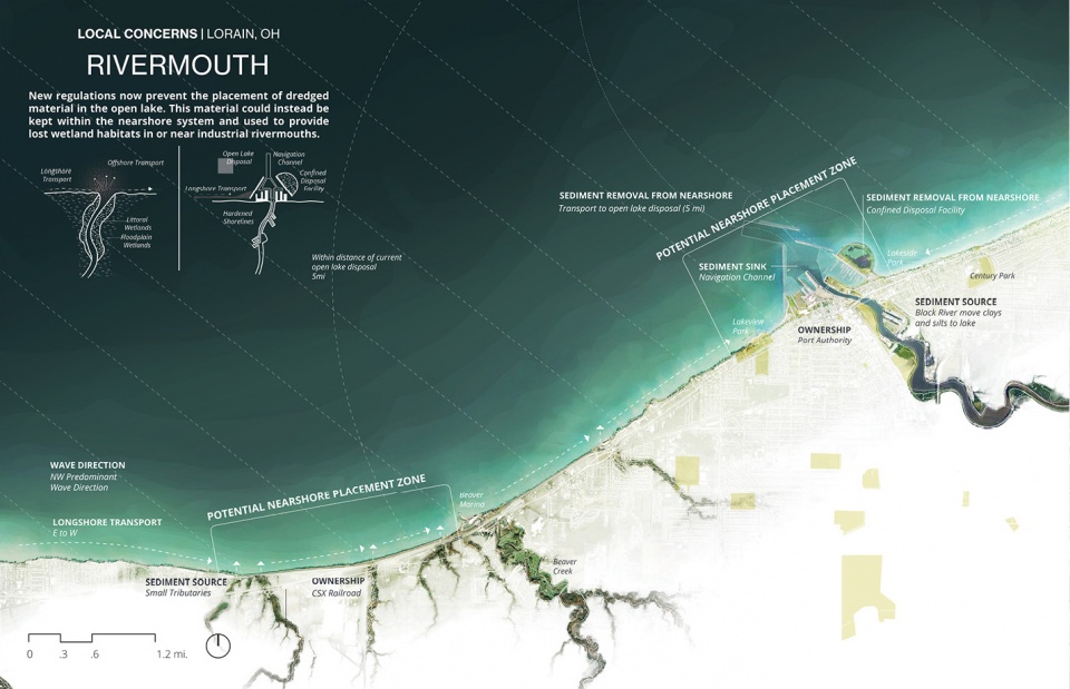
▲工业河口-当地条件:俄亥俄州几乎已经失去了所有的历史湿地。新实施的法规已经暂停在开放的湖域放置疏浚材料,并转而利用这些材料在工业河口或者附近区域修复失去的湿地生境。Industrial Rivermouth: Local Conditions: The state of Ohio has lost almost all of their historic wetlands. New regulations now prevent the placement of dredged material in the open lake. This material could instead be used to aid in providing lost wetland habitats in or near industrial rivermouths. ©Healthy Port Futures
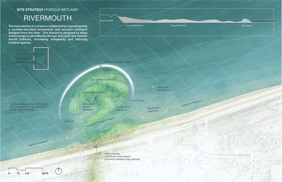
▲工业河口-场地自然力和策略:洛雷恩的干预措施是修复湿地,并通过高度可变的环状防浪堤提供保护(采用了从河道中挖出的沉积物)。该措施能够让波浪对沼泽栖息地进行周期性的瓦解和重置,以增加环境的复杂性并减少入侵物种。Industrial Rivermouth: Site Forces and Strategies: The intervention in Lorain is a wetland protected by a variable-elevation breakwater ring and contains sediment dredged from the river. This feature is designed to allow wave energy to periodically disrupt and reset the interior marsh habitats, increasing complexity and reducing invasive species. ©Healthy Port Futures
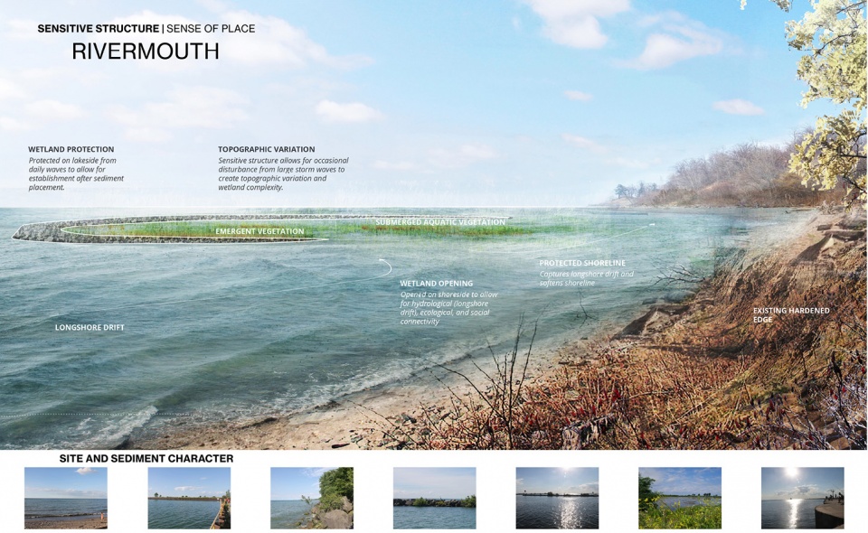
▲工业河口-敏感结构:靠近城市的湿地及其周围的栖息地成为了一个适合垂钓和皮划艇运动的休闲场所。Industrial Rivermouth: Sensitive Structure: Due to its urban location, the wetland and its associated habitat will serve as an amenity for both local recreational fishing and kayakers. ©Healthy Port Futures
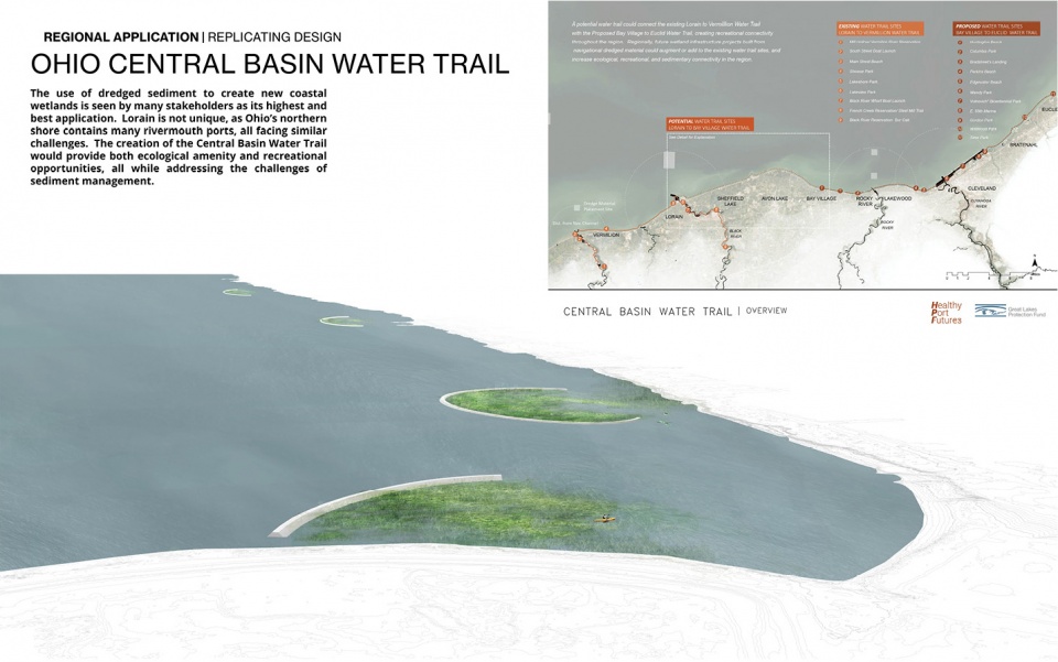
▲区域影响-中央流域水路:洛雷恩的环境条件具有一定的普遍性,因为全州的河口港区都需要找到一个重新规划开放湖域的替代方案。利用疏浚的沉积物构建湖岸湿地网络,不仅能够带来当地缺乏的湿地生境,还可以借助贯穿全州的水路来提供独一无二的休闲机会。Regional Effects: Central Basin Water Trail: The condition in Lorain is not unique, as rivermouth ports across the state need to find alternatives for open lake disposal. The creation of a network of coastal wetlands, made from dredged sediments could provide both much needed wetland habitat and unique recreational opportunities as a water trail across the state. ©Healthy Port Futures
PROJECT NARRATIVE
The Regional Situation
The Great Lakes situation is a harbinger of the effects of climate change on other coasts. Water levels are at historic highs across the basin, causing massive losses in property, public space, and habitat. But the situation is more complex than simply rising waters. Water level fluctuations have reached all-time record high and low levels in the past decade, increasing uncertainty in risk management, restoration, and coastal protection. Developing methods of planning and design that can address these unprecedented coastal conditions at scale is necessary given our reliance on these landscapes as residential, agricultural, recreational, ecological and industrial lands, and places of cultural and historical significance. Designing with sediment at a regional and local scale offers a way to reimagine fundamental aesthetic and civic questions through landscape architecture.
We use analysis and planning to leverage forcing conditions to produce more desirable outcomes cultural and ecological outcomes from sediment projects. This requires an approach that integrates these forces and works over time, rather than merely defending against them. Landscape architecture is proving a highly effective discipline to manage such a process. It links the vast array of disciplines engaged in coastal design and can form synthetic links between the analysis, outreach, design, monitoring and response phases of a project. In our project this takes the form of a series of sensitive structures in three locations, informed by context and functioning over time.
Sensitive Structures
In each case that follows the proposals developed are sensitive to regional and local environmental conditions, history, economy, and cultural values. This sensitivity is exhibited through both their engagement with environmental forces such as waves, wind, and emergent vegetation, but also as structures that have served to garner consensus and understanding about local sediment management alternatives through outreach, collaboration, and continual revision. Planned for unprecedented contexts, sensitive structures both meet immediate community goals and serve as experimental tools for gaining knowledge about systems and how to adapt to new conditions and goals in the future.
Where to work
The project began at the scale of the entire Great Lakes Basin. One of the key components of the analytical work was to establish the scope of intervention, and identify key partners and locations that demonstrated a range of forcing conditions, spanned the basin’s geography, and showed opportunity for larger-scale deployment. The goal was basin-wide impact through local intervention. Three of the sites chosen were the Port of Lorain, Ohio (Lake Erie), the recreational harbor of Port Bay, New York (Lake Ontario) and the coast of Illinois Beach State Park (Lake Michigan).
Engagement and Partnerships
Port Bay, New York | Drumlin / Bay System
The geography around Port Bay in Northern New York consists of a series of coastal drumlin bluffs that slowly erode and transport sediment to the east by way of longshore transport. This sediment tends to create barrier sandbars that separate a collection of bays from Lake Ontario. In Port Bay, the community concerns included two separate-but-linked topics. The first was the annual dredging of the small channel connecting the Bay to the lake and what to do with this material. Typically the cobble-rich sediment was simply placed as close to the channel as possible– effectively the least-cost option. The second concern was that the barrier bar east of the channel that protects the bay from lake waves has frequently been breached in recent years. While this breaching is a natural process, the bar is struggling to recover over the last decade due to a lack of sediment.
Working with the State Department of Environmental Conservation, the Wayne County Soil and Water Department, the Port Bay Improvement District and the local dredging contractor, our project links the annual dredging to the potential of nourishing the barrier bar without increased cost to the community. This occurs by way of placing the material into a new drumline feeder positioned in the nearshore, below the water line. It reproduces the activity of the regional drumlins at the scale of annual dredging operations and human perception, and is intended to be quickly eroded by wave action toward the weakened sandbar. This process will begin in the summer of 2020 and will be monitored, allowing for necessary tuning in the form and location of the erodible bluff in the coming years.
Illinois Beach State Park | Ridge-Swale Topography
The topographic feature that characterizes the Illinois Beach State Park is the beach ridge plain. This landscape is composed of a series of shore-parallel sand ridges with wetlands between them. The habitat created by the beach ridge, in particular the interdunal panne wetlands that develop between them, is incredibly rare and a priority conservation area for federal and state agencies. But as a dynamic system, the coastal conditions of the park are continually shifting, with a present-day net erosion on the north area of the park and a net gain in the southern area. This process is exacerbated by climate change and the increased intensity of storms that fuel the longshore transport process. As the landscape erodes, habitats that took thousands of years to develop are washed away in months or years.
Working the State Department of Natural Resources, the Illinois Geologic Service, the United States Army Corps of Engineers and the local Sand Management working group, our project identified the opportunity to extend the ridge-and-swale topography into the nearshore aquatic environment, creating a thickened coastal landscape that slows erosion without stopping longshore sediment transport while also providing aquatic habitat. Designed as a set of deformable underwater stone ridges, the proposal will attempt to provide sufficient wave reduction without the visual obstruction and high cost of emergent breakwaters. If successful, our project could reduce both the cost and visual impact necessary to protect this valuable habit.
Lorain, Ohio | Industrial Rivermouth
The geologic story of the southern shore of Lake Erie is one of former lakebed sediments deposited during glaciation that have now become some of the best agricultural land in the state of Ohio. This silty agricultural land erodes into slow-moving rivers that enter Lake Erie at rivermouth towns that developed as some of the most productive industrial and manufacturing hubs in the country. One of the legacies of this industry is the loss of valuable wetland ecosystems. Because of the need for navigation, shipping channels are continually dredged and a new regulation in the State of Ohio has placed a moratorium on the open water placement of dredged sediments.
Working with the United States Army Corps of Engineers, The State Environmental Protection Agency, the State Department of Natural Resources and the Lorain County Metroparks, we proposed a series of porous wetlands made from dredged sediment behind a stone ellipsoid arc. In a state that has lost upward of 80% of its coastal wetlands, the development of a series of newly created coastal wetlands is seen by the state EPA as the most beneficial use of dredged sediment possible. The feature is partially open to wave forces, allowing for daily waves to shape the sediment into complex shoreline wetland, and for some sediment release into the adjacent nearshore during storms. In addition, these features will also serve as valuable recreational fishing locations and areas of refuge during lake storms. As a larger system, this collection of wetlands will create a protected and ecologically rich water-trail stretching from Lorain to Cleveland Ohio.
From Planning to Implementation
All of the projects included here are slated for construction in the near future and monitoring will follow. The construction of these experimental pilot projects is the product of intensive planning, analysis and outreach, in addition to productive collaborations with other institutions and stakeholders. The Sensitive Structures project by Healthy Port Futures represents an expansion of the agency of landscape architecture in coastal environments.
More:ASLA;Healthy Port Futures




图纸表现真的绝了
喜欢这种规划图
ASLA的图一直酷炫